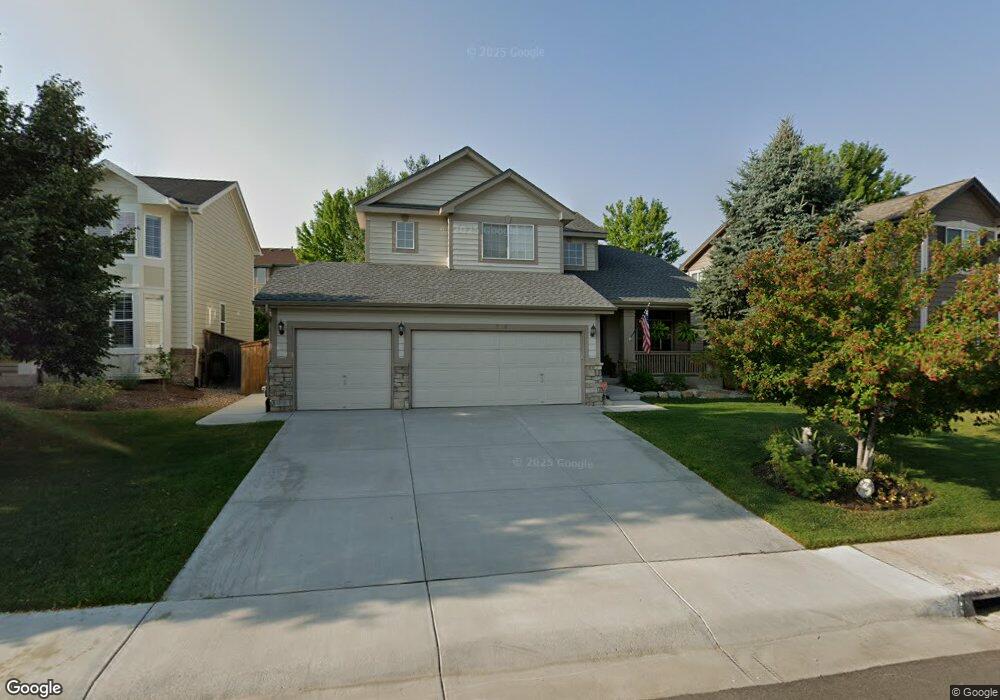
17136 Cornerstone Ln Parker, CO 80134
Clarke Farms NeighborhoodEstimated Value: $756,000 - $809,000
5
Beds
4
Baths
3,657
Sq Ft
$211/Sq Ft
Est. Value
About This Home
This home is located at 17136 Cornerstone Ln, Parker, CO 80134 and is currently estimated at $772,462, approximately $211 per square foot. 17136 Cornerstone Ln is a home located in Douglas County with nearby schools including Cherokee Trail Elementary School, Sierra Middle School, and Chaparral High School.
Ownership History
Date
Name
Owned For
Owner Type
Purchase Details
Closed on
Mar 25, 2016
Sold by
Johnson William W and Johnson Stephanie J
Bought by
Harder Deborah S and Winter Erica Marie
Current Estimated Value
Home Financials for this Owner
Home Financials are based on the most recent Mortgage that was taken out on this home.
Original Mortgage
$431,048
Outstanding Balance
$343,700
Interest Rate
4.12%
Mortgage Type
FHA
Estimated Equity
$428,762
Purchase Details
Closed on
May 12, 2005
Sold by
Metzger Joseph E and Metzger Cheryl F
Bought by
Johnson William W and Johnson Stephanie J
Home Financials for this Owner
Home Financials are based on the most recent Mortgage that was taken out on this home.
Original Mortgage
$287,920
Interest Rate
6.03%
Mortgage Type
Fannie Mae Freddie Mac
Purchase Details
Closed on
Dec 15, 1998
Sold by
Ryland Group Inc
Bought by
Metzger Cheryl F Metzger Joseph E
Purchase Details
Closed on
Jul 27, 1998
Sold by
Stonegate Westerra
Bought by
Ryland Group Inc
Create a Home Valuation Report for This Property
The Home Valuation Report is an in-depth analysis detailing your home's value as well as a comparison with similar homes in the area
Home Values in the Area
Average Home Value in this Area
Purchase History
| Date | Buyer | Sale Price | Title Company |
|---|---|---|---|
| Harder Deborah S | $439,000 | Guardian Title | |
| Johnson William W | $359,900 | Fahtco | |
| Metzger Cheryl F Metzger Joseph E | $238,700 | -- | |
| Ryland Group Inc | $216,600 | -- |
Source: Public Records
Mortgage History
| Date | Status | Borrower | Loan Amount |
|---|---|---|---|
| Open | Harder Deborah S | $431,048 | |
| Previous Owner | Johnson William W | $287,920 |
Source: Public Records
Tax History
| Year | Tax Paid | Tax Assessment Tax Assessment Total Assessment is a certain percentage of the fair market value that is determined by local assessors to be the total taxable value of land and additions on the property. | Land | Improvement |
|---|---|---|---|---|
| 2025 | $5,552 | $45,550 | $10,750 | $34,800 |
| 2024 | $5,552 | $55,530 | $9,830 | $45,700 |
| 2023 | $5,600 | $55,530 | $9,830 | $45,700 |
| 2022 | $4,091 | $37,060 | $6,600 | $30,460 |
| 2021 | $4,206 | $37,060 | $6,600 | $30,460 |
| 2020 | $3,941 | $35,590 | $7,200 | $28,390 |
| 2019 | $3,845 | $35,590 | $7,200 | $28,390 |
| 2018 | $3,519 | $32,130 | $6,510 | $25,620 |
| 2017 | $3,319 | $32,130 | $6,510 | $25,620 |
| 2016 | $3,307 | $31,510 | $5,570 | $25,940 |
| 2015 | $1,685 | $31,510 | $5,570 | $25,940 |
| 2014 | $3,232 | $27,240 | $5,410 | $21,830 |
Source: Public Records
Map
Nearby Homes
- 17130 Opal Hill Dr
- 17351 Cornerstone Dr
- 10318 Severance Dr
- 10221 Amethyst Way
- 10539 Holyoke Dr
- 10505 Berthoud Way
- 9652 Deerhorn Ct Unit 106
- 10520 Holyoke Dr
- 10518 Holyoke Dr
- 9608 Deerhorn Ct Unit 81
- 16430 Amberstone Way
- 10607 Clarke Farms Dr
- 11605 Masonville Dr
- 16351 Parkside Dr
- 17034 Wellington Dr
- 9800 Cheewall Ln
- 9783 Cheewall Ln
- 9482 S Alyssum Way
- 16213 Quarry Hill Dr
- 16224 Quarry Hill Dr
- 17144 Cornerstone Ln
- 17126 Cornerstone Ln
- 17156 Cornerstone Ln
- 17093 Opal Hill Dr
- 17112 Cornerstone Ln
- 17079 Opal Hill Dr
- 17107 Opal Hill Dr
- 17065 Opal Hill Dr
- 17139 Cornerstone Ln
- 17125 Cornerstone Ln
- 17121 Opal Hill Dr
- 17168 Cornerstone Ln
- 17088 Cornerstone Ln
- 17153 Cornerstone Ln
- 17111 Cornerstone Ln
- 17049 Opal Hill Dr
- 17167 Cornerstone Ln
- 17135 Opal Hill Dr
- 17182 Cornerstone Ln
- 17099 Cornerstone Ln
Your Personal Tour Guide
Ask me questions while you tour the home.