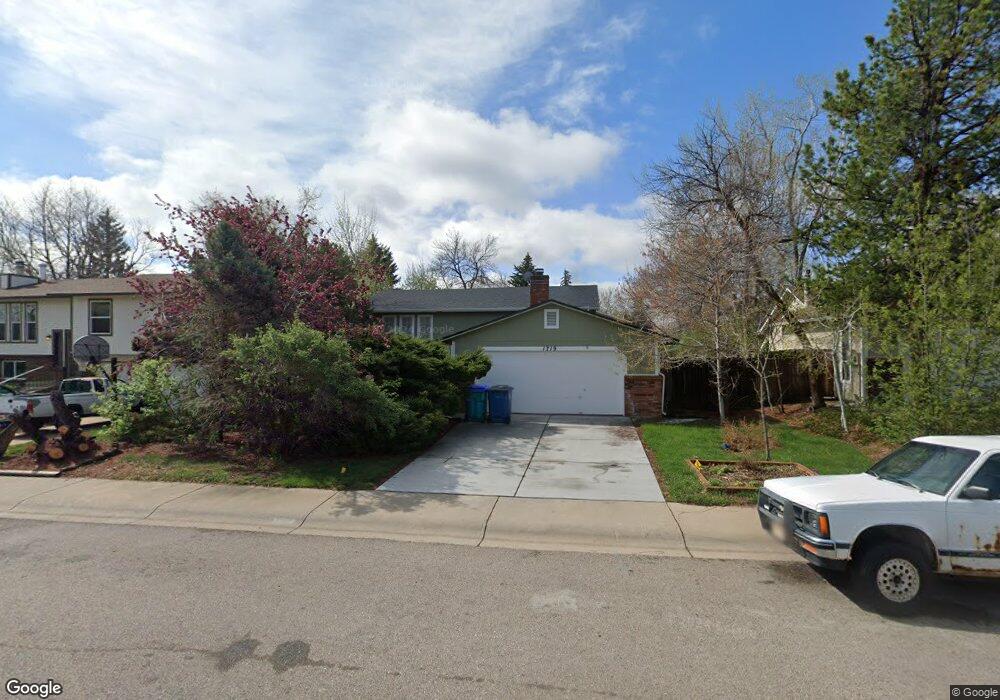
1719 Fremont Ct Fort Collins, CO 80526
Estimated Value: $498,208 - $634,000
2
Beds
2
Baths
1,818
Sq Ft
$299/Sq Ft
Est. Value
About This Home
This home is located at 1719 Fremont Ct, Fort Collins, CO 80526 and is currently estimated at $543,052, approximately $298 per square foot. 1719 Fremont Ct is a home located in Larimer County with nearby schools including Bennett Elementary School, Blevins Middle School, and Rocky Mountain High School.
Ownership History
Date
Name
Owned For
Owner Type
Purchase Details
Closed on
Aug 16, 2001
Sold by
Stclair Susan
Bought by
Thiel Karl E and Thiel Sandra A
Current Estimated Value
Home Financials for this Owner
Home Financials are based on the most recent Mortgage that was taken out on this home.
Original Mortgage
$175,279
Outstanding Balance
$68,324
Interest Rate
7.14%
Estimated Equity
$474,728
Purchase Details
Closed on
Jul 1, 1993
Sold by
Tsuchiya Candice C
Bought by
Stclair Susan
Create a Home Valuation Report for This Property
The Home Valuation Report is an in-depth analysis detailing your home's value as well as a comparison with similar homes in the area
Home Values in the Area
Average Home Value in this Area
Purchase History
| Date | Buyer | Sale Price | Title Company |
|---|---|---|---|
| Thiel Karl E | $180,700 | -- | |
| Stclair Susan | $94,500 | -- |
Source: Public Records
Mortgage History
| Date | Status | Borrower | Loan Amount |
|---|---|---|---|
| Open | Thiel Karl E | $175,279 |
Source: Public Records
Tax History Compared to Growth
Tax History
| Year | Tax Paid | Tax Assessment Tax Assessment Total Assessment is a certain percentage of the fair market value that is determined by local assessors to be the total taxable value of land and additions on the property. | Land | Improvement |
|---|---|---|---|---|
| 2025 | $2,289 | $34,244 | $2,680 | $31,564 |
| 2024 | $2,178 | $34,244 | $2,680 | $31,564 |
| 2022 | $2,319 | $24,561 | $2,780 | $21,781 |
| 2021 | $2,344 | $25,268 | $2,860 | $22,408 |
| 2020 | $2,447 | $26,155 | $2,860 | $23,295 |
| 2019 | $2,458 | $26,155 | $2,860 | $23,295 |
| 2018 | $1,927 | $21,139 | $2,880 | $18,259 |
| 2017 | $1,920 | $21,139 | $2,880 | $18,259 |
| 2016 | $1,662 | $18,205 | $3,184 | $15,021 |
| 2015 | $1,650 | $18,200 | $3,180 | $15,020 |
| 2014 | $1,448 | $15,870 | $3,180 | $12,690 |
Source: Public Records
Map
Nearby Homes
- 2613 Hanover Dr
- 2855 Trenton Way
- 2718 Dunbar Ave
- 2706 Dunbar Ave
- 2109 W Drake Rd
- 1905 Yorktown Ave
- 2800 S Taft Hill Rd
- 1757 Concord Dr
- 1601 W Swallow Rd Unit 1
- 1601 W Swallow Rd Unit 9
- 1601 W Swallow Rd
- 2918 Silverplume Dr Unit C1
- 2738 Bradford Square
- 2420 Sheffield Cir E
- 1531 W Swallow Rd Unit 25
- 1531 W Swallow Rd Unit 28
- 2828 Silverplume Dr
- 2828 Silverplume Dr Unit R3
- 1419 Glen Haven Dr
- 2607 S Taft Hill Rd