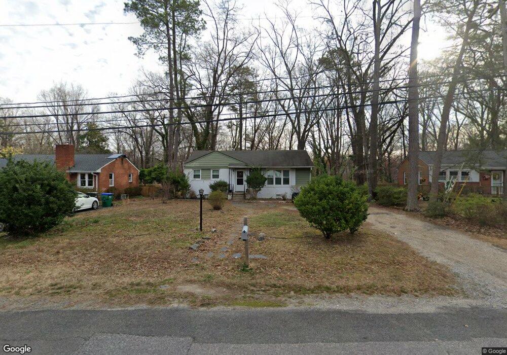
1719 Leicester Rd Richmond, VA 23225
Westover Hills NeighborhoodEstimated Value: $294,442 - $330,000
3
Beds
1
Bath
1,040
Sq Ft
$301/Sq Ft
Est. Value
About This Home
This home is located at 1719 Leicester Rd, Richmond, VA 23225 and is currently estimated at $312,861, approximately $300 per square foot. 1719 Leicester Rd is a home located in Richmond City with nearby schools including Westover Hills Elementary School, Huguenot High School, and Open High School.
Ownership History
Date
Name
Owned For
Owner Type
Purchase Details
Closed on
Nov 26, 2002
Sold by
Ackman Elaine F
Bought by
Ackman Family Partnership
Current Estimated Value
Purchase Details
Closed on
May 16, 1997
Sold by
Gibson Edgar M and Gibson Husband
Bought by
Ackman Barry A and Ackman Elaine S
Home Financials for this Owner
Home Financials are based on the most recent Mortgage that was taken out on this home.
Original Mortgage
$53,100
Interest Rate
8.12%
Mortgage Type
New Conventional
Create a Home Valuation Report for This Property
The Home Valuation Report is an in-depth analysis detailing your home's value as well as a comparison with similar homes in the area
Home Values in the Area
Average Home Value in this Area
Purchase History
| Date | Buyer | Sale Price | Title Company |
|---|---|---|---|
| Ackman Family Partnership | -- | -- | |
| Ackman Barry A | $29,500 | -- |
Source: Public Records
Mortgage History
| Date | Status | Borrower | Loan Amount |
|---|---|---|---|
| Previous Owner | Ackman Barry A | $53,100 |
Source: Public Records
Tax History Compared to Growth
Tax History
| Year | Tax Paid | Tax Assessment Tax Assessment Total Assessment is a certain percentage of the fair market value that is determined by local assessors to be the total taxable value of land and additions on the property. | Land | Improvement |
|---|---|---|---|---|
| 2025 | $2,952 | $246,000 | $68,000 | $178,000 |
| 2024 | $2,568 | $214,000 | $45,000 | $169,000 |
| 2023 | $2,520 | $210,000 | $45,000 | $165,000 |
| 2022 | $2,136 | $178,000 | $45,000 | $133,000 |
| 2021 | $1,584 | $135,000 | $35,000 | $100,000 |
| 2020 | $1,584 | $132,000 | $35,000 | $97,000 |
| 2019 | $1,404 | $117,000 | $35,000 | $82,000 |
| 2018 | $1,404 | $117,000 | $35,000 | $82,000 |
| 2017 | $1,368 | $114,000 | $35,000 | $79,000 |
| 2016 | $1,368 | $114,000 | $35,000 | $79,000 |
| 2015 | $1,356 | $113,000 | $35,000 | $78,000 |
| 2014 | $1,356 | $113,000 | $35,000 | $78,000 |
Source: Public Records
Map
Nearby Homes
- 1722 Leicester Rd
- 5204 Forest Hill Ave
- 5205 Forest Hill Ave
- 5504 Riverside Heights Way
- 5636 Forest Hill Ave
- 5600 Riverside Heights Way
- 5612 Southern Pine Dr
- 2324 N Riverside Dr
- 5021 Caledonia Rd
- 2320 Pineway Dr
- 1004 Hill Top Dr
- 5804 Riverside Dr
- 912 Forest View Dr
- 1025 Forest View School Dr
- 911 Hill Top Dr
- 4621 Devonshire Rd
- 1112 Blandy Ave
- 1937 Lansing Ave
- 816 Faye St
- 4605 Forest Hill Ave
- 1725 Leicester Rd
- 1713 Leicester Rd
- 1731 Leicester Rd
- 1707 Leicester Rd
- 1714 Leicester Rd
- 1737 Leicester Rd
- 1703 Leicester Rd
- 5330 Sylvan Rd
- 1728 Leicester Rd
- 1712 Leicester Rd
- 1743 Leicester Rd
- 5346 Forest Hill Ave
- 1734 Leicester Rd
- 5414 Forest Hill Ave
- 5312 Sylvan Rd
- 5310 Sylvan Rd
- 5340 Forest Hill Ave
- 5314 Sylvan Rd
- 5420 Forest Hill Ave
- 1749 Leicester Rd