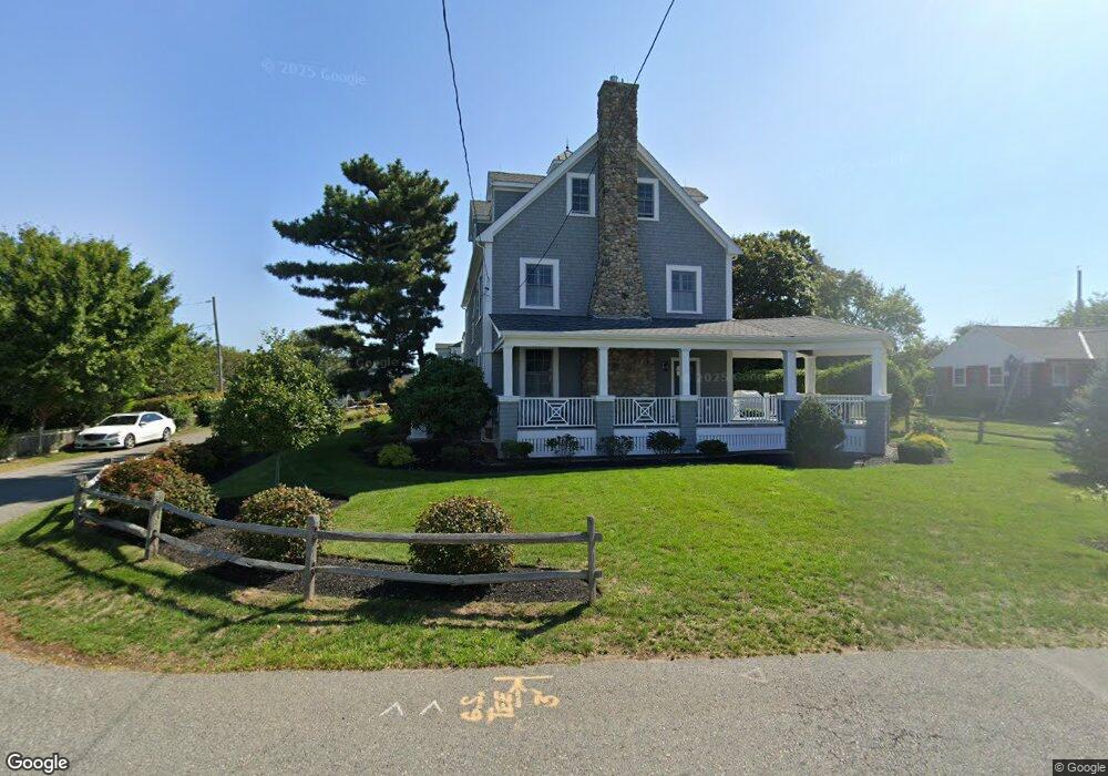
172 Edward Foster Rd Scituate, MA 02066
Estimated Value: $2,813,000 - $3,092,063
5
Beds
5
Baths
4,632
Sq Ft
$641/Sq Ft
Est. Value
About This Home
This home is located at 172 Edward Foster Rd, Scituate, MA 02066 and is currently estimated at $2,968,016, approximately $640 per square foot. 172 Edward Foster Rd is a home located in Plymouth County with nearby schools including Jenkins Elementary School, Lester J. Gates Middle School, and Scituate High School.
Ownership History
Date
Name
Owned For
Owner Type
Purchase Details
Closed on
May 10, 2021
Sold by
Petit Ft and Petit
Bought by
Childs Frederick C and Crittendon Janna L
Current Estimated Value
Home Financials for this Owner
Home Financials are based on the most recent Mortgage that was taken out on this home.
Original Mortgage
$756,000
Outstanding Balance
$684,926
Interest Rate
3.35%
Mortgage Type
Purchase Money Mortgage
Estimated Equity
$2,283,090
Purchase Details
Closed on
Mar 24, 2011
Sold by
Vegkley E Foster Road and Petit
Bought by
Pettit Ft and Petit
Purchase Details
Closed on
Apr 14, 2008
Sold by
Vegkley Mary A
Bought by
Vegkley Edward Road T and Vegkley Mary A
Create a Home Valuation Report for This Property
The Home Valuation Report is an in-depth analysis detailing your home's value as well as a comparison with similar homes in the area
Home Values in the Area
Average Home Value in this Area
Purchase History
| Date | Buyer | Sale Price | Title Company |
|---|---|---|---|
| Childs Frederick C | $1,260,000 | None Available | |
| Pettit Ft | -- | -- | |
| Vegkley Edward Road T | -- | -- | |
| Pettit Ft | -- | -- | |
| Vegkley Edward Road T | -- | -- |
Source: Public Records
Mortgage History
| Date | Status | Borrower | Loan Amount |
|---|---|---|---|
| Open | Childs Frederick C | $756,000 |
Source: Public Records
Tax History Compared to Growth
Tax History
| Year | Tax Paid | Tax Assessment Tax Assessment Total Assessment is a certain percentage of the fair market value that is determined by local assessors to be the total taxable value of land and additions on the property. | Land | Improvement |
|---|---|---|---|---|
| 2025 | $26,151 | $2,617,700 | $1,142,500 | $1,475,200 |
| 2024 | $31,059 | $2,998,000 | $1,093,300 | $1,904,700 |
| 2023 | $14,165 | $2,188,000 | $993,900 | $1,194,100 |
| 2022 | $14,165 | $1,122,400 | $837,600 | $284,800 |
| 2021 | $14,027 | $1,052,300 | $797,800 | $254,500 |
| 2020 | $13,784 | $1,021,000 | $767,000 | $254,000 |
| 2019 | $10,328 | $751,700 | $501,300 | $250,400 |
| 2018 | $10,553 | $756,500 | $495,900 | $260,600 |
| 2017 | $10,362 | $735,400 | $474,800 | $260,600 |
| 2016 | $10,123 | $715,900 | $464,200 | $251,700 |
| 2015 | $9,102 | $694,800 | $443,100 | $251,700 |
Source: Public Records
Map
Nearby Homes
- 23 Sunset Rd
- 91 Front St Unit 106
- 32 Barker Rd Unit 3
- 12 Richfield Rd
- 50 First Parish Rd
- 12 Meeting House Ln Unit 308
- 105 Turner Rd
- 76 A Brook St
- 76 A Brook St Unit 1
- 23 Oceanside Dr
- 74 Tilden Rd
- 23 Lois Ann Ct Unit 23
- 59 Greenfield Ln
- 67 Greenfield Ln
- 2 Collier Rd
- 209 Hatherly Rd
- 30 Irving Rd
- 37 Moorland Rd
- 17 Bradford Ave
- 111 Elm St
- 35 Circuit Ave
- 170 Edward Foster Rd
- 178 Edward Foster Rd
- 33 Circuit Ave
- 180 Edward Foster Rd
- 30 Circuit Ave
- 169 Edward Foster Rd
- 12 Circuit Ave
- 165 Edward Foster Rd
- 160 Edward Foster Rd
- 184 Edward Foster Rd
- 179 Edward Foster Rd
- 13 Circuit Ave
- 7 Sunset Rd
- 6 Roberts Dr
- 27 Circuit Ave Unit 29
- 25 Circuit Ave
- 185 Edward Foster Rd
- 21 Circuit Ave
- 154 Edward Foster Rd