NOT LISTED FOR SALE

172 Salisbury Rd Conneaut, OH 44030

Estimated Value: $81,000

106 Acres
$764 Price per Acre
4,617,360 Sq Ft Lot

Last Sold May 27, 2020

Last sale price $163,553 $136 Per Sq Ft

Est. 50% decrease in value since last sale

Current estimated payment $512/month

29 Days on Market

About This Lot

As of May 2020

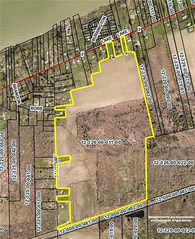
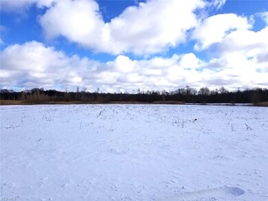
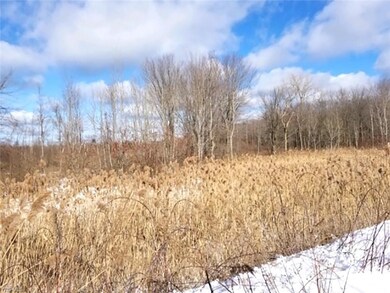
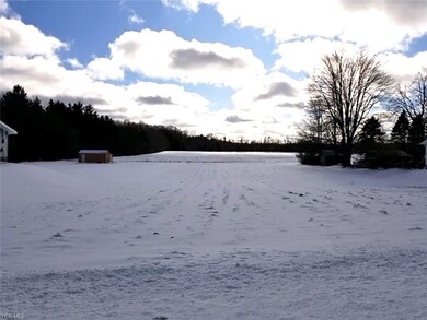
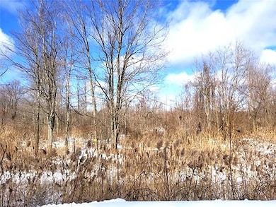
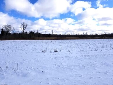
Attention Hunters and Developers - 106 Acres Of Land - Woods And Open Fields - Near Lake Erie – Conneaut, OH – Ashtabula County - ABSOLUTE AUCTION, the property will sell in its entirety to the highest bidder on location: SATURDAY – MARCH 14, 2020 – 11:00 AM. Property located across the road from Lake Erie featuring 106 acres with about half of the property in open tillable land and the back half wooded. Includes frontage on Salisbury Rd., plus frontage on Lake Rd. with 2 lots totaling 226’ frontage. Current taxes on the entirety is $556.00 per year. Located in Ashtabula County, parcel #123260001100, #123260001104, and #123260008401. Great opportunity! Walk the land over at your convenience. Plan to attend! TERMS ON REAL ESTATE: 10% down auction day, balance due at closing. A 10% buyer’s premium will be added to the highest bid to establish the purchase price, which goes to the seller. Any desired inspections must be made prior to bidding. All information contained herein was derived from sources believed to be correct. Information is believed to be accurate but not guaranteed. Property to be sold as an entirety and not to be offered in separate parcels.

Last Agent to Sell the Property

Theresa Blocher

Kiko License #700341127 Listed on: 02/14/2020

Last Buyer's Agent

Theresa Blocher

Kiko License #700341127 Listed on: 02/14/2020

Property Details

Property Type

  • Land

Est. Annual Taxes

  • $556

Lot Details

  • 106 Acre Lot

Utilities

  • Water Not Available
  • Sewer Not Available

Community Details

  • City/Conneaut Community

Listing and Financial Details

  • Assessor Parcel Number 123260001100

Property Details

Property Type

Land

Est. Annual Taxes

$556

Lot Details

0

Listing Details

  • Property Type: Land
  • Property Subtype: Land
  • Geocode Confidence: Unknown
  • Special Features: Auction
  • Property Sub Type: LotsLands

Exterior Features

  • Tillable Acres: 50.0000
  • Wooded Acres: 50.0000

Utilities

  • Water/Sewer: No Water, No Sewer

Condo/Co-op/Association

  • Subdivision Complex: City/Conneaut

Schools

  • School District: Conneaut Area CSD
  • School District: Conneaut Area Csd

Lot Info

  • Additional Assessor Parcel Number 1: 123260001104
  • Additional Assessor Parcel Number 2: 123260008401
  • Lot Size Units: Acres
  • Acres: 106.0000
  • Topography: Level, Wooded
  • Parcel Number: 123260001100

Multi Family

  • Number Of Lots: 1

Tax Info

  • Tax: 556

Ownership History

Date Name Owned For Owner Type

Purchase Details

Listed on
Feb 14, 2020
Closed on
May 21, 2020
Sold by
Stehli Robert C and Stehli Marie Louise
Bought by
Spink Cynthia C and Spink Richard R
Seller's Agent
Theresa Blocher
Kiko
Buyer's Agent
Theresa Blocher
Kiko
List Price
$163,553
Sold Price
$163,553
Total Days on Market
29
Current Estimated Value
$81,000

Home Financials for this Owner

Home Financials are based on the most recent Mortgage that was taken out on this home.
Estimated Appreciation
-$82,553
Original Mortgage
$114,200
Outstanding Balance
$93,066
Interest Rate
3.3%
Mortgage Type
Commercial

Purchase Details

Closed on
Dec 12, 2018
Sold by
Coxon Gary L
Bought by
Stehli Robert C and Stehli Marie Louise

Purchase Details

Closed on
Jul 14, 2017
Sold by
Coxon Gary L
Bought by
Coxon Gary and Estate Of William E Winslow

Purchase Details

Closed on
Apr 8, 2017
Sold by
Coxon Gary L
Bought by
Estate Of William E Winslow

Purchase Details

Closed on
Mar 3, 2011
Sold by
Rutherford Jerold D
Bought by
Winslow William
Source: Public Records

Range of Values:

Collateral Analytics

Collateral Analytics Collateral Analytics AVMs (Automated Valuation Model) employ a number of statistical approaches combined with neighborhood-specific comparable selection guarantees the most up-to-date and precise valuations.

Not Available

Collateral Analytics does not have data for the current month. Please view the chart for historical values.

ICE

ICE Mortgage Technology ICE Mortgage Technology’s AVM (Automated Valuation Model) is a state-of-the-art online residential property valuation tool that provides a quick and accurate estimate of the value of almost any home in the U.S.

Not Available

ICE Mortgage Technology does not have data for the current month. Please view the chart for historical values.

First American

First American First American Data & Analytics’ next-generation AVM combines unrivaled data assets with a blended ensemble of valuation models to produce highly accurate, reliable valuations you can trust.

Not Available

First American does not have data for the current month. Please view the chart for historical values.

Quantarium

Quantarium Quantarium’s valuation service, repeatedly proven the industry’s most accurate and comprehensive, is supercharged with a self-learning and auto-tuning AI engine that continually becomes smarter and more accurate as it processes daily inputs from the industry’s leading RE data lake.

Not Available

Quantarium does not have data for the current month. Please view the chart for historical values.

Average Value
Not Available
List Price
Sold Price
Create a Home Valuation Report for This Property
The Home Valuation Report is an in-depth analysis detailing your home's value as well as a comparison with similar homes in the area

Home Values in the Area

Source: Public Records

Average Home Value in this Area


Source: Public Records

Purchase History

Date Buyer Sale Price Title Company
Spink Cynthia C $163,553 Title Professionals Group Lt
Stehli Robert C $237,000 Chicago Title Agency
Coxon Gary -- Chicago Title
Estate Of William E Winslow -- None Available
Winslow William $67,878 None Available
Source: Public Records

Mortgage History

Date Status Borrower Loan Amount
Open Spink Cynthia C $114,200
Previous Owner Rutherford Jerold D $114,000
Previous Owner Rutherford Jerold $87,500
Source: Public Records

Property History

Date Event Price Change Sq Ft Price
05/27/2020 05/27/20 Sold $163,553 0.0% $136 / Sq Ft
03/14/2020 03/14/20 Pending -- -- --
02/14/2020 02/14/20 For Sale $163,553 -- $136 / Sq Ft
Source: MLS Now

Tax History Compared to Growth

Source: Public Records

Tax History

Year Tax Paid Tax Assessment Tax Assessment Total Assessment is a certain percentage of the fair market value that is determined by local assessors to be the total taxable value of land and additions on the property. Land Improvement
2024 $759 $105,810 $105,810 --
2023 $488 $105,810 $105,810 $0
2022 $554 $81,410 $81,410 $0
2021 $564 $81,410 $81,410 $0
2020 $564 $81,410 $81,410 $0
2019 $575 $53,170 $53,170 $0
2018 $548 $53,170 $53,170 $0
2017 $937 $53,170 $53,170 $0
2016 $1,401 $29,300 $9,800 $19,500
2015 $1,416 $29,300 $9,800 $19,500
2014 $1,247 $29,300 $9,800 $19,500
2013 $1,146 $27,650 $6,300 $21,350
Source: Public Records

Agents Affiliated with this Home

  • Section Image
See All Agents

Map

Source: MLS Now

MLS Number: 4167860

MLS Now

APN: 123260001100