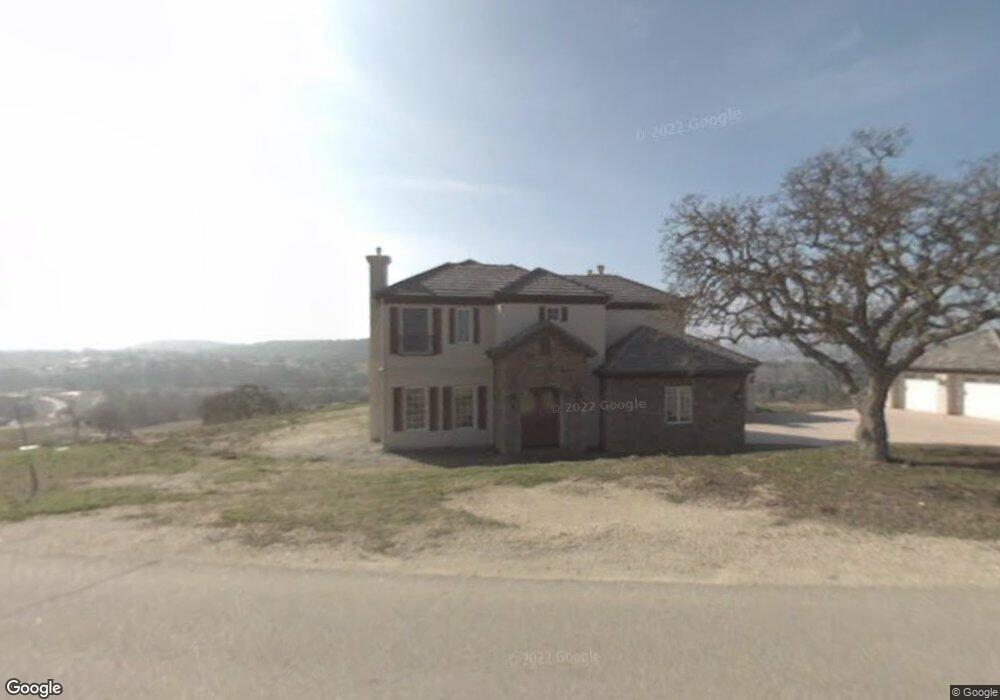
1725 Cumbre Rd Paso Robles, CA 93446
Estimated Value: $1,916,000 - $2,541,504
4
Beds
5
Baths
5,325
Sq Ft
$438/Sq Ft
Est. Value
About This Home
This home is located at 1725 Cumbre Rd, Paso Robles, CA 93446 and is currently estimated at $2,332,126, approximately $437 per square foot. 1725 Cumbre Rd is a home located in San Luis Obispo County with nearby schools including Pat Butler Elementary School, George H. Flamson Middle School, and Paso Robles High School.
Ownership History
Date
Name
Owned For
Owner Type
Purchase Details
Closed on
Mar 26, 2013
Sold by
Taylor Thomas T and Daniels Aeri Yoon
Bought by
Taylor Thomas T and Daniels Aeri Yoon
Current Estimated Value
Purchase Details
Closed on
Mar 24, 1997
Sold by
Cunningham Wayne and Cunningham Rita A
Bought by
Daniels Richard and Daniels Aeri
Home Financials for this Owner
Home Financials are based on the most recent Mortgage that was taken out on this home.
Original Mortgage
$115,000
Outstanding Balance
$14,094
Interest Rate
7.86%
Mortgage Type
Seller Take Back
Estimated Equity
$2,318,032
Purchase Details
Closed on
Dec 18, 1996
Sold by
Cunningham Wayne and Cunningham Rita A
Bought by
Cunningham Wayne and Cunningham Rita A
Create a Home Valuation Report for This Property
The Home Valuation Report is an in-depth analysis detailing your home's value as well as a comparison with similar homes in the area
Purchase History
| Date | Buyer | Sale Price | Title Company |
|---|---|---|---|
| Taylor Thomas T | -- | None Available | |
| Taylor Thomas T | -- | None Available | |
| Daniels Richard | $135,000 | Fidelity National Title Co | |
| Cunningham Wayne | -- | -- |
Source: Public Records
Mortgage History
| Date | Status | Borrower | Loan Amount |
|---|---|---|---|
| Open | Daniels Richard | $115,000 |
Source: Public Records
Tax History
| Year | Tax Paid | Tax Assessment Tax Assessment Total Assessment is a certain percentage of the fair market value that is determined by local assessors to be the total taxable value of land and additions on the property. | Land | Improvement |
|---|---|---|---|---|
| 2025 | $17,885 | $1,690,271 | $295,886 | $1,394,385 |
| 2024 | $17,562 | $1,657,130 | $290,085 | $1,367,045 |
| 2023 | $17,562 | $1,624,639 | $284,398 | $1,340,241 |
| 2022 | $17,261 | $1,592,784 | $278,822 | $1,313,962 |
| 2021 | $16,922 | $1,561,554 | $273,355 | $1,288,199 |
| 2020 | $16,749 | $1,545,544 | $270,553 | $1,274,991 |
| 2019 | $16,420 | $1,515,241 | $265,249 | $1,249,992 |
| 2018 | $16,098 | $1,485,532 | $260,049 | $1,225,483 |
| 2017 | $15,076 | $1,456,404 | $254,950 | $1,201,454 |
| 2016 | $14,780 | $1,427,848 | $249,951 | $1,177,897 |
| 2015 | $14,555 | $1,406,401 | $246,197 | $1,160,204 |
| 2014 | $14,008 | $1,378,853 | $241,375 | $1,137,478 |
Source: Public Records
Map
Nearby Homes
- 1690 Barley Grain Rd
- 1655 Barley Grain Rd
- 1505 Barley Grain Rd
- 253 Silver Oak Dr
- 1990 Calle Los Charros
- 829 Saint Andrews Cir
- 842 Saint Andrews Cir
- 1880 Fire Rock Loop
- 1920 Fire Rock Loop
- 919 Saint Ann Dr
- 1309 Stoney Creek Rd
- 1340 Stoney Creek Rd
- 2035 Calle Pattito
- 2466 Beechwood Dr
- 2314 Ashwood Place
- 1934 Tulipwood Dr
- 795 Angus St
- 1810 LOT 28 Fire Rock Loop
- 2220 Battering Rock Rd
- 17 Green Ct
- 1870 Cumbre Rd
- 1750 Cumbre Rd
- 1885 Cumbre Rd
- 1190 Ladera Ln
- 1690 Cumbre Rd
- 1675 Cumbre Rd
- 1150 Ladera Ln
- 1880 Cumbre Rd
- 1125 Ladera Ln
- 1688 Barley Grain Rd
- 1620 Barley Grain Rd
- 1630 Cumbre Rd
- 1705 Arbolado Rd
- 1070 Ladera Ln
- 1919 Barley Grain Rd
- 1980 Barley Grain Rd
- 1895 Laguna Del Campo Unit 37
- 1895 Laguna Del Campo
- 1615 Cumbre Rd
- 1885 Laguna Del Campo Unit 38
Your Personal Tour Guide
Ask me questions while you tour the home.