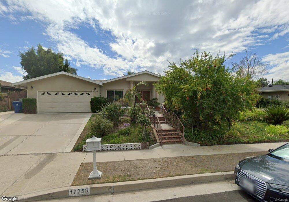
17256 Barneston Ct Granada Hills, CA 91344
Estimated Value: $1,326,000 - $1,502,000
4
Beds
3
Baths
2,702
Sq Ft
$513/Sq Ft
Est. Value
About This Home
This home is located at 17256 Barneston Ct, Granada Hills, CA 91344 and is currently estimated at $1,387,149, approximately $513 per square foot. 17256 Barneston Ct is a home located in Los Angeles County with nearby schools including Robert Frost Middle School, Valley Academy of Arts & Sciences, and Northridge Academy High.
Ownership History
Date
Name
Owned For
Owner Type
Purchase Details
Closed on
Jul 14, 2014
Sold by
Parvinjah Masoud
Bought by
The Parvinjah Ejabat Family Trust
Current Estimated Value
Purchase Details
Closed on
Nov 4, 1993
Sold by
Muench James P and Muench Eileen M Mcginty
Bought by
Parvinjah Masoud
Home Financials for this Owner
Home Financials are based on the most recent Mortgage that was taken out on this home.
Original Mortgage
$202,000
Interest Rate
3.95%
Create a Home Valuation Report for This Property
The Home Valuation Report is an in-depth analysis detailing your home's value as well as a comparison with similar homes in the area
Home Values in the Area
Average Home Value in this Area
Purchase History
| Date | Buyer | Sale Price | Title Company |
|---|---|---|---|
| The Parvinjah Ejabat Family Trust | -- | None Available | |
| Parvinjah Masoud | $252,727 | Commonwealth Land Title |
Source: Public Records
Mortgage History
| Date | Status | Borrower | Loan Amount |
|---|---|---|---|
| Previous Owner | Parvinjah Masoud | $202,000 |
Source: Public Records
Tax History Compared to Growth
Tax History
| Year | Tax Paid | Tax Assessment Tax Assessment Total Assessment is a certain percentage of the fair market value that is determined by local assessors to be the total taxable value of land and additions on the property. | Land | Improvement |
|---|---|---|---|---|
| 2025 | $7,285 | $569,112 | $144,268 | $424,844 |
| 2024 | $7,285 | $557,954 | $141,440 | $416,514 |
| 2023 | $7,152 | $547,015 | $138,667 | $408,348 |
| 2022 | $6,834 | $536,291 | $135,949 | $400,342 |
| 2021 | $6,742 | $525,777 | $133,284 | $392,493 |
| 2019 | $6,550 | $510,184 | $129,332 | $380,852 |
| 2018 | $6,377 | $500,182 | $126,797 | $373,385 |
| 2016 | $5,447 | $427,948 | $121,874 | $306,074 |
| 2015 | $5,371 | $421,521 | $120,044 | $301,477 |
| 2014 | $5,311 | $413,265 | $117,693 | $295,572 |
Source: Public Records
Map
Nearby Homes
- 11811 Louise Ave
- 11830 Babbitt Ave
- 17242 Bircher St
- 12025 Adrian Place
- 11542 Encino Ave
- 17420 Flanders St
- 11725 Balboa Blvd
- 12001 Shoshone Ave
- 11737 Lois Ct
- 17014 Rinaldi St
- 17901 Mayerling St
- 12128 Nugent Dr
- 11628 Lerdo Ave
- 17823 Rinaldi St
- 17350 Angelaine Way
- 16814 Rinaldi St
- 11538 Zelzah Ave
- 12426 Henzie Place
- 11223 White Oak Ave
- 17558 Lahey St
- 17264 Barneston Ct
- 17257 Mayerling St
- 17263 Mayerling St
- 17245 Barneston Ct
- 17271 Mayerling St
- 17251 Mayerling St
- 11820 Louise Ave
- 11850 Louise Ave
- 11810 Louise Ave
- 17245 Mayerling St
- 17238 Barneston Ct
- 17242 Barneston Ct
- 17262 Mayerling St
- 17256 Mayerling St
- 17235 Barneston Ct
- 17239 Mayerling St
- 11858 Louise Ave
- 7380 Rainbow Ridge Cir
- 17234 Barneston Ct
- 17270 Mayerling St