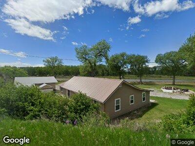
1732 Spring Creek Rd Laurel, MT 59044
Estimated Value: $359,000 - $506,000
2
Beds
1
Bath
1,666
Sq Ft
$253/Sq Ft
Est. Value
About This Home
This home is located at 1732 Spring Creek Rd, Laurel, MT 59044 and is currently estimated at $421,357, approximately $252 per square foot. 1732 Spring Creek Rd is a home located in Yellowstone County with nearby schools including Fred W. Graff School, West School, and Laurel Middle School.
Ownership History
Date
Name
Owned For
Owner Type
Purchase Details
Closed on
May 28, 2024
Sold by
Glembocki Robert S
Bought by
Glembocki Cecilia
Current Estimated Value
Purchase Details
Closed on
Jul 7, 2015
Sold by
Glembocki Robert S
Bought by
Glembocki Robert S and Glembocki Cecilia
Purchase Details
Closed on
Nov 30, 2006
Sold by
Putnam Walt and Putnam Danette M
Bought by
Glembocki Robert S
Home Financials for this Owner
Home Financials are based on the most recent Mortgage that was taken out on this home.
Original Mortgage
$161,910
Interest Rate
6.37%
Mortgage Type
New Conventional
Create a Home Valuation Report for This Property
The Home Valuation Report is an in-depth analysis detailing your home's value as well as a comparison with similar homes in the area
Home Values in the Area
Average Home Value in this Area
Purchase History
| Date | Buyer | Sale Price | Title Company |
|---|---|---|---|
| Glembocki Robert S | -- | Stewart Title | |
| Glembocki Robert S | -- | None Available |
Source: Public Records
Mortgage History
| Date | Status | Borrower | Loan Amount |
|---|---|---|---|
| Previous Owner | Glembocki Robert S | $166,000 | |
| Previous Owner | Glembocki Robert S | $161,910 |
Source: Public Records
Tax History Compared to Growth
Tax History
| Year | Tax Paid | Tax Assessment Tax Assessment Total Assessment is a certain percentage of the fair market value that is determined by local assessors to be the total taxable value of land and additions on the property. | Land | Improvement |
|---|---|---|---|---|
| 2024 | $1,739 | $261,500 | $76,906 | $184,594 |
| 2023 | $1,739 | $261,500 | $76,906 | $184,594 |
| 2022 | $1,327 | $195,500 | $0 | $0 |
| 2021 | $1,323 | $195,500 | $0 | $0 |
| 2020 | $1,268 | $184,000 | $0 | $0 |
| 2019 | $1,219 | $184,000 | $0 | $0 |
| 2018 | $1,310 | $170,600 | $0 | $0 |
| 2017 | $1,190 | $170,600 | $0 | $0 |
| 2016 | $1,140 | $166,700 | $0 | $0 |
| 2015 | $1,121 | $166,700 | $0 | $0 |
| 2014 | $1,013 | $80,984 | $0 | $0 |
Source: Public Records
Map
Nearby Homes
- 1920 Spring Creek (Tract B-4b1) Rd
- 2907 Clarks Point Dr
- 40 Acres Denittis Ln
- 900 Beretta Dr
- 3904 Retreat Dr
- TBD Grandkids Way
- 1506 Thiel Rd
- 5154 Brohaugh Rd
- 2623 Lackawanna Ln
- 2618 Topeka Dr
- 3801 Spring Creek Rd
- 2413 Atchison Dr
- Lot 16 Clarks Point Dr
- 5154 Brohaugh Tract 1a-2
- 1911 E Maryland Ln
- 793 Clarks River Rd
- 612 Washington Ave
- 219 E 1st St
- 211 Woodland Ave
- 213 Woodland Ave
- 1732 Spring Creek Rd
- 1816 Spring Creek Rd
- 1912 Spring Creek Rd
- 1920 Spring Creek Rd
- 3223 River Rd
- 3223 River Rd Unit Laurel
- 3319 River Rd
- 1938 Spring Creek Rd
- 2133 Spring Creek Rd
- 2911 Clarks Point Dr
- 3365 River Rd
- 2903 Clarks Point Dr
- 1936 Spring Creek Rd
- 3443 River Rd
- TBD 15 Acres River Road (Approx)
- 1419 N River Rd
- 0 Clarks Point Dr
- LOT 7 Clarks Point Dr
- Lot 11A Clarks Point Dr
- Lot 18 Clarks Point Dr