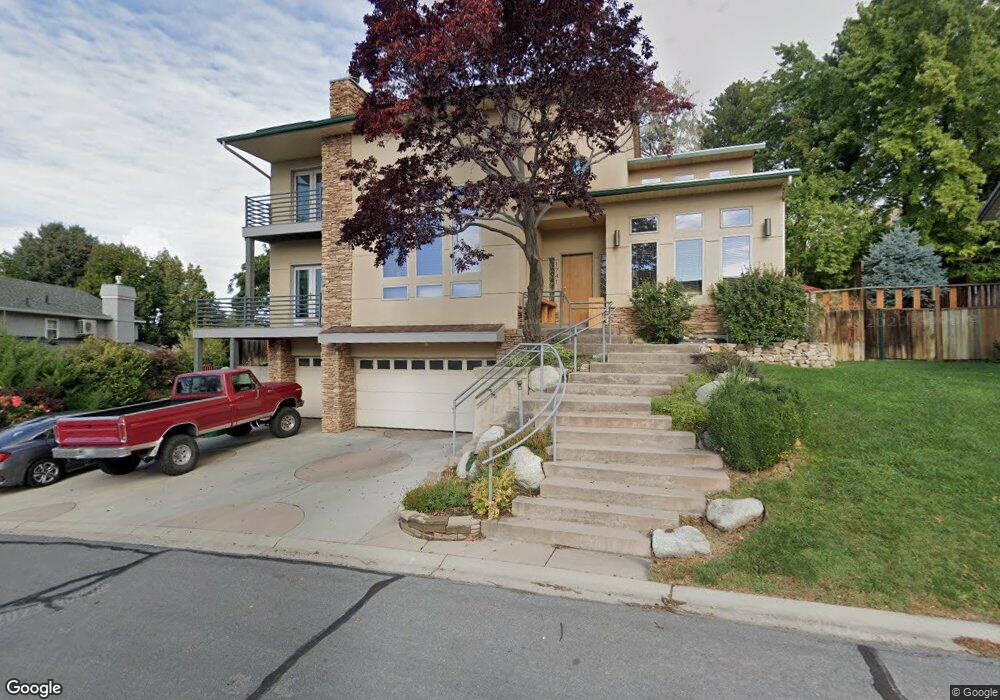
1741 Meadowlark Rd Orem, UT 84097
Northridge NeighborhoodEstimated Value: $818,745 - $1,039,000
5
Beds
4
Baths
4,156
Sq Ft
$217/Sq Ft
Est. Value
About This Home
This home is located at 1741 Meadowlark Rd, Orem, UT 84097 and is currently estimated at $903,248, approximately $217 per square foot. 1741 Meadowlark Rd is a home located in Utah County with nearby schools including Orchard Elementary School, Oak Canyon Junior High School, and Timpanogos High School.
Ownership History
Date
Name
Owned For
Owner Type
Purchase Details
Closed on
Feb 26, 2020
Sold by
Farer Jeffrey Kent and Farer Rhonna Mark
Bought by
Allen Mark
Current Estimated Value
Home Financials for this Owner
Home Financials are based on the most recent Mortgage that was taken out on this home.
Original Mortgage
$447,200
Outstanding Balance
$396,807
Interest Rate
3.6%
Mortgage Type
New Conventional
Estimated Equity
$506,441
Purchase Details
Closed on
Aug 11, 2017
Sold by
Farrer Jeffrey Kent and Farrer Rhonna Mask
Bought by
Farrer Jeffrey Kent and Farrer Rhonna Mask
Home Financials for this Owner
Home Financials are based on the most recent Mortgage that was taken out on this home.
Original Mortgage
$250,000
Interest Rate
3.96%
Purchase Details
Closed on
Oct 29, 2014
Sold by
Farrer Jeffrey K and Farrer Rhonna
Bought by
Farrer Family Trust and Farrer Rhoanna Mask
Create a Home Valuation Report for This Property
The Home Valuation Report is an in-depth analysis detailing your home's value as well as a comparison with similar homes in the area
Home Values in the Area
Average Home Value in this Area
Purchase History
| Date | Buyer | Sale Price | Title Company |
|---|---|---|---|
| Allen Mark | -- | Pro Title & Escrow Inc | |
| Farrer Jeffrey Kent | -- | First American | |
| Farrer Family Trust | -- | None Available |
Source: Public Records
Mortgage History
| Date | Status | Borrower | Loan Amount |
|---|---|---|---|
| Open | Allen Mark | $447,200 | |
| Previous Owner | Farrer Jeffrey Kent | $250,000 |
Source: Public Records
Tax History
| Year | Tax Paid | Tax Assessment Tax Assessment Total Assessment is a certain percentage of the fair market value that is determined by local assessors to be the total taxable value of land and additions on the property. | Land | Improvement |
|---|---|---|---|---|
| 2025 | $3,153 | $443,245 | -- | -- |
| 2024 | $3,153 | $385,605 | $0 | $0 |
| 2023 | $2,950 | $387,695 | $0 | $0 |
| 2022 | $2,838 | $361,295 | $0 | $0 |
| 2021 | $2,577 | $496,900 | $173,500 | $323,400 |
| 2020 | $2,421 | $458,900 | $150,900 | $308,000 |
| 2019 | $2,275 | $448,400 | $140,400 | $308,000 |
| 2018 | $2,260 | $425,600 | $140,400 | $285,200 |
| 2017 | $2,263 | $268,730 | $0 | $0 |
| 2016 | $2,881 | $267,960 | $0 | $0 |
| 2015 | $2,762 | $242,990 | $0 | $0 |
| 2014 | -- | $215,490 | $0 | $0 |
Source: Public Records
Map
Nearby Homes
- 540 E Quail Rd
- 1480 N 430 E
- 695 E 1870 N
- 1636 N 160 E
- 1638 N 160 E
- 363 E 1395 N Unit 22
- 1643 N Mountain Oaks Dr
- 723 E 1450 N Unit 25
- 110 S 1320 E
- 1371 N 330 E Unit 8
- 713 E 1500 St N Unit 19
- 713 E 1450 N Unit 23
- 747 E 1500 N Unit 13
- 1366 N 750 E
- 733 E 1450 N Unit 5
- 1356 N 750 E Unit 11
- 1324 N 750 E Unit 3
- 49 W 1880 N
- 710 E 1280 N
- 372 E 1165 N
- 1729 Meadowlark Rd
- 521 Meadowlark Rd
- 1754 Heather Dr
- 1728 Meadowlark Rd
- 1755 Bluebird Rd
- 1746 Heather Dr
- 1709 Bluebird Rd
- 1716 Meadowlark Rd
- 1715 Meadowlark Rd
- 1760 Heather Dr
- 1771 Bluebird Rd
- 1732 Bluebird Rd
- 1732 Heather Dr
- 1702 Meadowlark Rd
- 1760 Bluebird Rd
- 1697 Bluebird Rd
- 1703 Meadowlark Rd
- 1747 N Heather Dr
- 1747 Heather Dr
- 1716 N Heather Dr
Your Personal Tour Guide
Ask me questions while you tour the home.