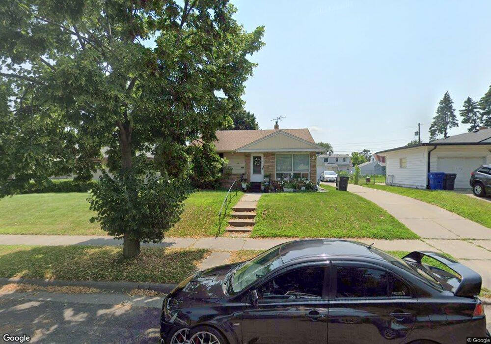
1748 Conway St Saint Paul, MN 55106
Battle Creek NeighborhoodEstimated Value: $277,000 - $289,000
3
Beds
2
Baths
753
Sq Ft
$376/Sq Ft
Est. Value
About This Home
This home is located at 1748 Conway St, Saint Paul, MN 55106 and is currently estimated at $283,435, approximately $376 per square foot. 1748 Conway St is a home located in Ramsey County with nearby schools including Battle Creek Elementary School, Battle Creek Middle School, and Harding Senior High School.
Ownership History
Date
Name
Owned For
Owner Type
Purchase Details
Closed on
Nov 24, 2021
Sold by
Sheng Thao
Bought by
Thao Sheng and Vang Anthony C
Current Estimated Value
Home Financials for this Owner
Home Financials are based on the most recent Mortgage that was taken out on this home.
Original Mortgage
$126,500
Interest Rate
3.56%
Mortgage Type
New Conventional
Purchase Details
Closed on
Jun 5, 2015
Bought by
Seng Seng
Home Financials for this Owner
Home Financials are based on the most recent Mortgage that was taken out on this home.
Original Mortgage
$120,000
Interest Rate
3.87%
Create a Home Valuation Report for This Property
The Home Valuation Report is an in-depth analysis detailing your home's value as well as a comparison with similar homes in the area
Home Values in the Area
Average Home Value in this Area
Purchase History
| Date | Buyer | Sale Price | Title Company |
|---|---|---|---|
| Thao Sheng | $500 | Key Title | |
| Seng Seng | $153,500 | -- |
Source: Public Records
Mortgage History
| Date | Status | Borrower | Loan Amount |
|---|---|---|---|
| Previous Owner | Thao Sheng | $126,500 | |
| Previous Owner | Seng Seng | $120,000 |
Source: Public Records
Tax History Compared to Growth
Tax History
| Year | Tax Paid | Tax Assessment Tax Assessment Total Assessment is a certain percentage of the fair market value that is determined by local assessors to be the total taxable value of land and additions on the property. | Land | Improvement |
|---|---|---|---|---|
| 2025 | $3,600 | $271,000 | $50,100 | $220,900 |
| 2023 | $3,600 | $241,900 | $31,100 | $210,800 |
| 2022 | $3,330 | $261,100 | $31,200 | $229,900 |
| 2021 | $3,014 | $218,400 | $31,200 | $187,200 |
| 2020 | $2,870 | $196,800 | $31,200 | $165,600 |
| 2019 | $2,390 | $174,200 | $31,200 | $143,000 |
| 2018 | $2,266 | $156,900 | $31,200 | $125,700 |
| 2017 | $2,148 | $147,500 | $31,200 | $116,300 |
| 2016 | $1,986 | $0 | $0 | $0 |
| 2015 | $1,686 | $127,500 | $31,200 | $96,300 |
| 2014 | $1,494 | $0 | $0 | $0 |
Source: Public Records
Map
Nearby Homes
- 1821 Wilson Ave
- 1685 Fremont Ave
- 1600 Old Hudson Rd
- 1935 Fremont Ave E
- 1751 Margaret St
- 1964 4th St E
- 1538 Wilson Ave
- 465 Ruth St N
- 1683 Minnehaha Ave E
- 1675 Minnehaha Ave E
- 1551 Margaret St
- 1590 Minnehaha Ave E
- 267 Hazelwood St
- 1764 Bush Ave
- 1450 Fremont Ave
- 1489 6th St E
- 1803 Bush Ave E
- 1685 Bush Ave
- 237 Sigurd St
- 1493 Margaret St
- 1754 Conway St
- 1742 Conway St
- 1736 Conway St
- 1751 Euclid St
- 1757 Euclid St
- 1745 Euclid St
- 1751 Euclid St
- 471 White Bear Ave N
- 1739 Euclid St
- 477 White Bear Ave N
- 465 White Bear Ave N
- 461 White Bear Ave N
- 1733 Euclid St
- 1728 Conway St
- 453 White Bear Ave N
- 1729 Euclid St
- 1724 Conway St
- 1750 1750 Euclid-Street-
- 1750 Euclid St
- 1720 Conway St