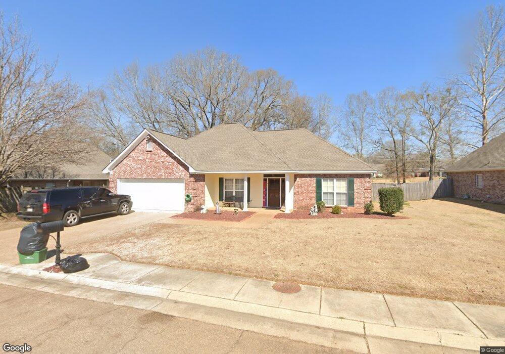
176 Navajo Cir Clinton, MS 39056
Estimated Value: $265,643 - $306,000
3
Beds
2
Baths
1,966
Sq Ft
$147/Sq Ft
Est. Value
About This Home
This home is located at 176 Navajo Cir, Clinton, MS 39056 and is currently estimated at $289,411, approximately $147 per square foot. 176 Navajo Cir is a home located in Hinds County with nearby schools including Clinton Park Elementary School, Eastside Elementary School, and Northside Elementary School.
Ownership History
Date
Name
Owned For
Owner Type
Purchase Details
Closed on
Apr 16, 2010
Sold by
Olson Shawn O and Shepherd Misty
Bought by
Frazier Fernandeis A and Frazier Bertha
Current Estimated Value
Home Financials for this Owner
Home Financials are based on the most recent Mortgage that was taken out on this home.
Original Mortgage
$176,739
Interest Rate
4.94%
Create a Home Valuation Report for This Property
The Home Valuation Report is an in-depth analysis detailing your home's value as well as a comparison with similar homes in the area
Home Values in the Area
Average Home Value in this Area
Purchase History
| Date | Buyer | Sale Price | Title Company |
|---|---|---|---|
| Frazier Fernandeis A | -- | -- |
Source: Public Records
Mortgage History
| Date | Status | Borrower | Loan Amount |
|---|---|---|---|
| Previous Owner | Frazier Fernandeis A | $176,739 |
Source: Public Records
Tax History Compared to Growth
Tax History
| Year | Tax Paid | Tax Assessment Tax Assessment Total Assessment is a certain percentage of the fair market value that is determined by local assessors to be the total taxable value of land and additions on the property. | Land | Improvement |
|---|---|---|---|---|
| 2025 | $3,737 | $24,344 | $6,000 | $18,344 |
| 2024 | $3,737 | $24,344 | $6,000 | $18,344 |
| 2023 | $3,737 | $16,229 | $4,000 | $12,229 |
| 2022 | $2,467 | $16,229 | $4,000 | $12,229 |
| 2021 | $2,167 | $16,229 | $4,000 | $12,229 |
| 2020 | $2,089 | $15,826 | $4,000 | $11,826 |
| 2019 | $2,137 | $15,826 | $4,000 | $11,826 |
| 2018 | $2,137 | $15,826 | $4,000 | $11,826 |
| 2017 | $2,046 | $15,826 | $4,000 | $11,826 |
| 2016 | $2,046 | $15,826 | $4,000 | $11,826 |
| 2015 | $2,007 | $15,612 | $4,000 | $11,612 |
| 2014 | $2,007 | $15,612 | $4,000 | $11,612 |
Source: Public Records
Map
Nearby Homes
- 149 Navajo Cir
- 103 Buffalo Cove
- 107 Trace Pointe Place
- 110 Trace Pointe Place
- 114 Trace Pointe Place
- 116 Trace Pointe Place
- 1203 Rockingham Dr
- 1422 Huntcliff Way
- 1221 Huntcliff Way
- 1219 Canterbury Ln
- 102 Friars Cove
- 102 Park Place
- 605 Herndon Hill
- 603 Herndon Hill
- 1301 Beverly Dr
- 0 Huntcliff Way
- 1200 Canterbury Ln
- 305 Linda Dr
- 504 Hampton St
- 1011 Laurelwood Dr
- 174 Navajo Cir
- 200 Navajo Cir
- 153 Navajo Cir
- 151 Navajo Cir
- 201 Navajo Cir
- 0 Apache Ct Unit lot 95 1146326
- 0 Apache Ct Unit lot 86 1139228
- 0 Apache Ct Unit lot 87 1139417
- 0 Apache Ct Unit Lot 97 1134905
- 0 Apache Ct Unit lot 96 1132529
- 0 Apache Ct Unit Lot 92 1109820
- 170 Navajo Cir
- 101 Apache Ct
- 100 Navajo Cir
- 101 Navajo Cir
- 147 Navajo Cir
- 109 Apache Ct
- 113 Arrow Dr
- 113 Arrow Dr Unit 39
- 103 Apache Ct