Estimated Value: $365,153 - $449,000
4
Beds
3
Baths
2,460
Sq Ft
$166/Sq Ft
Est. Value
About This Home
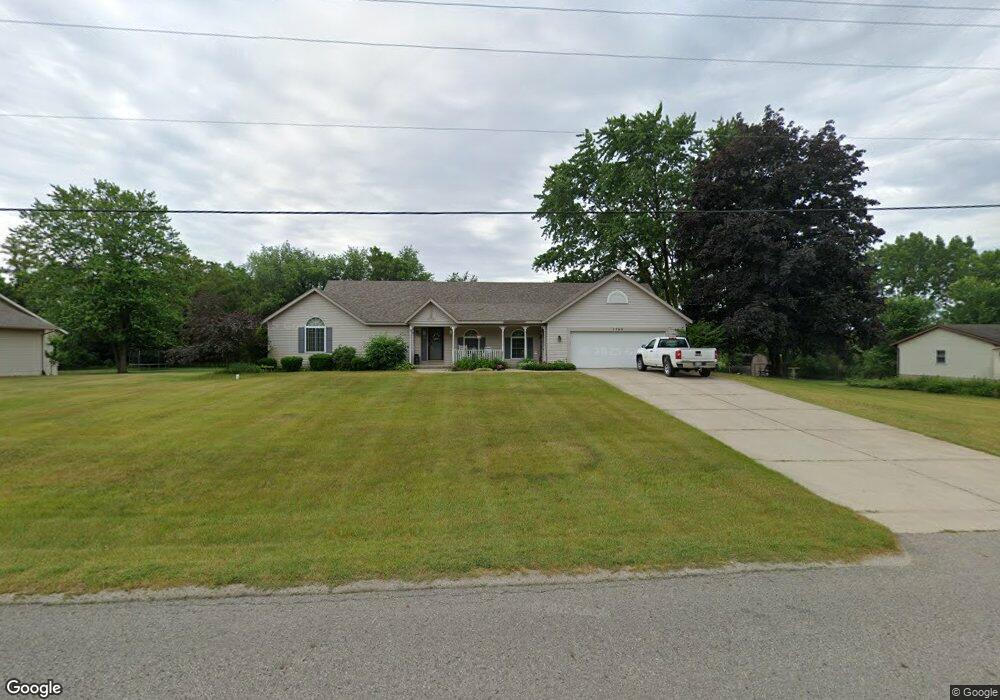
This home is located at 1768 143rd Ave, Dorr, MI 49323 and is currently estimated at $408,538, approximately $166 per square foot. 1768 143rd Ave is a home located in Allegan County with nearby schools including Wayland High School, Byron Center Charter School, and St. Stanislaus School.
Ownership History
Date
Name
Owned For
Owner Type
Purchase Details
Closed on
Aug 22, 2007
Sold by
Vanhouten Mark H and Vanhouten Connie S
Bought by
Deutsche Bank National Trust Co
Current Estimated Value
Purchase Details
Closed on
Mar 1, 2007
Sold by
Vanhouten Mark H and Vanhouten Connie S
Bought by
Deutsche Bank National Trust Co
Purchase Details
Closed on
Jul 21, 2000
Sold by
Vanvuuren Phillip R
Bought by
Vanhouten Mark H and Vanhouten Connie
Purchase Details
Closed on
Nov 9, 1996
Sold by
Vanvuuren Phillip R
Create a Home Valuation Report for This Property
The Home Valuation Report is an in-depth analysis detailing your home's value as well as a comparison with similar homes in the area
Home Values in the Area
Average Home Value in this Area
Purchase History
| Date | Buyer | Sale Price | Title Company |
|---|---|---|---|
| Deutsche Bank National Trust Co | -- | E Title Agency | |
| Deutsche Bank National Trust Co | $270,323 | None Available | |
| Vanhouten Mark H | $200,000 | -- | |
| -- | -- | -- |
Source: Public Records
Tax History
| Year | Tax Paid | Tax Assessment Tax Assessment Total Assessment is a certain percentage of the fair market value that is determined by local assessors to be the total taxable value of land and additions on the property. | Land | Improvement |
|---|---|---|---|---|
| 2025 | $3,835 | $152,600 | $3,800 | $148,800 |
| 2024 | $3,460 | $146,700 | $3,500 | $143,200 |
| 2023 | $3,546 | $131,800 | $3,500 | $128,300 |
| 2022 | $3,460 | $131,100 | $23,000 | $108,100 |
| 2021 | $3,262 | $126,900 | $23,000 | $103,900 |
| 2020 | $3,113 | $126,300 | $23,000 | $103,300 |
| 2019 | $3,113 | $124,600 | $23,000 | $101,600 |
| 2018 | $3,043 | $127,200 | $31,200 | $96,000 |
| 2017 | $0 | $105,800 | $15,400 | $90,400 |
| 2016 | $0 | $95,800 | $16,800 | $79,000 |
| 2015 | -- | $88,000 | $0 | $0 |
| 2014 | -- | $88,700 | $0 | $0 |
| 2013 | -- | $91,700 | $14,500 | $77,200 |
Source: Public Records
Map
Nearby Homes
- 1829 Sunset Dr
- 1341 142nd Ave
- Lots A&B 142nd Ave
- 4162 Radstock Dr
- 4221 Century Dr
- Lot 11 Walnut Dale Dr
- 4365 Chappel St
- 1232 Rosewood Ave
- 10780 Windward Ave SW
- 10785 Windward Ave SW
- 4273 Highpoint Dr Unit 112
- 4269 Highpoint Dr Unit 114
- 4271 Highpoint Dr Unit 113
- 4294 Highpoint Dr Unit 103
- 1069 Sunnyside Dr
- 10725 Windward Ave SW
- 10711 Windward Ave SW
- 4279 Highpoint Dr
- 4255 Cloverfield Ct
- 136 100th St SW
- 1774 143rd Ave
- 1764 143rd Ave
- 0 143rd Ave Unit M21001434
- 0 143rd Ave Unit M21106494
- 1839 143rd Ave
- 0 143rd Ave Unit APP 1
- 17641766 143rd Ave
- V/L 143rd Ave
- 1771 143rd Ave
- 1760 143rd Ave
- 1779 143rd Ave
- 1761 143rd Ave
- 1746 143rd Ave
- 1783 143rd Ave
- 4316 Deerfield Run
- 1768 Prairie Ct
- 1776 Prairie Ct
- 1755 143rd Ave
- 1780 Prairie Ct
- 4318 Deerfield Run
Your Personal Tour Guide
Ask me questions while you tour the home.