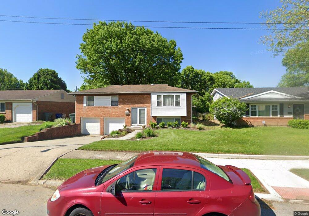
1783 Penfield Rd Columbus, OH 43227
Linwood NeighborhoodEstimated Value: $231,000 - $266,000
3
Beds
2
Baths
1,524
Sq Ft
$162/Sq Ft
Est. Value
About This Home
This home is located at 1783 Penfield Rd, Columbus, OH 43227 and is currently estimated at $247,171, approximately $162 per square foot. 1783 Penfield Rd is a home located in Franklin County with nearby schools including Scottwood Elementary School, Johnson Park Middle School, and Walnut Ridge High School.
Ownership History
Date
Name
Owned For
Owner Type
Purchase Details
Closed on
Nov 2, 2021
Sold by
Cornelius Angela L and Dawson John W
Bought by
Barnes Lane Bronshay A
Current Estimated Value
Home Financials for this Owner
Home Financials are based on the most recent Mortgage that was taken out on this home.
Original Mortgage
$196,337
Outstanding Balance
$179,632
Interest Rate
2.88%
Mortgage Type
FHA
Estimated Equity
$67,539
Purchase Details
Closed on
Apr 30, 1992
Bought by
Cornelius Angela L
Purchase Details
Closed on
Nov 18, 1991
Create a Home Valuation Report for This Property
The Home Valuation Report is an in-depth analysis detailing your home's value as well as a comparison with similar homes in the area
Home Values in the Area
Average Home Value in this Area
Purchase History
| Date | Buyer | Sale Price | Title Company |
|---|---|---|---|
| Barnes Lane Bronshay A | $200,000 | Atlas Title Solutions | |
| Cornelius Angela L | $69,800 | -- | |
| -- | -- | -- |
Source: Public Records
Mortgage History
| Date | Status | Borrower | Loan Amount |
|---|---|---|---|
| Open | Barnes Lane Bronshay A | $196,337 |
Source: Public Records
Tax History Compared to Growth
Tax History
| Year | Tax Paid | Tax Assessment Tax Assessment Total Assessment is a certain percentage of the fair market value that is determined by local assessors to be the total taxable value of land and additions on the property. | Land | Improvement |
|---|---|---|---|---|
| 2024 | $3,059 | $68,150 | $15,540 | $52,610 |
| 2023 | $1,526 | $34,440 | $15,540 | $18,900 |
| 2022 | $1,950 | $37,590 | $8,400 | $29,190 |
| 2021 | $1,953 | $37,590 | $8,400 | $29,190 |
| 2020 | $1,956 | $37,590 | $8,400 | $29,190 |
| 2019 | $1,902 | $31,360 | $7,000 | $24,360 |
| 2018 | $1,720 | $31,360 | $7,000 | $24,360 |
| 2017 | $1,800 | $31,360 | $7,000 | $24,360 |
| 2016 | $1,698 | $25,630 | $5,430 | $20,200 |
| 2015 | $1,541 | $25,630 | $5,430 | $20,200 |
| 2014 | $1,545 | $25,630 | $5,430 | $20,200 |
| 2013 | $846 | $28,455 | $6,020 | $22,435 |
Source: Public Records
Map
Nearby Homes
- 1778 Quigley Rd
- 1782 Newfield Rd
- 1637 S James Rd
- 1677 Kenview Rd
- 2844 Kingsrowe Ct Unit 27
- 2894 Landon Dr
- 2810 Kingsrowe Ct Unit 13
- 2846 Petzinger Rd Unit 70
- 2903 Scottwood Rd
- 1624 Miltwood Rd
- 1535 Kenwick Rd
- 3246 E Deshler Ave
- 1664 Barnett Rd
- 3038 Wadsworth Ct
- 3036 Wadsworth Ct
- 2639 Halleck Dr
- 2664 Sonata Dr
- 3325 E Deshler Ave
- 2911 Heath Ct
- 3084 Clermont Rd
- 1789 Penfield Rd
- 1777 Penfield Rd
- 1777 Penfield Rd
- 1795 Penfield Rd
- 1771 Penfield Rd
- 2966 Queensrowe Dr
- 1803 Penfield Rd
- 1765 Penfield Rd
- 1780 Niagara Rd
- 1790 Penfield Rd
- 2961 Queensrowe Dr
- 1767 Niagara Rd
- 1798 Penfield Rd
- 1807 Penfield Rd
- 2970 Queensrowe Dr
- 1806 Penfield Rd
- 1756 Penfield Rd
- 2965 Queensrowe Dr
- 1768 Niagara Rd
- 1753 Niagara Rd