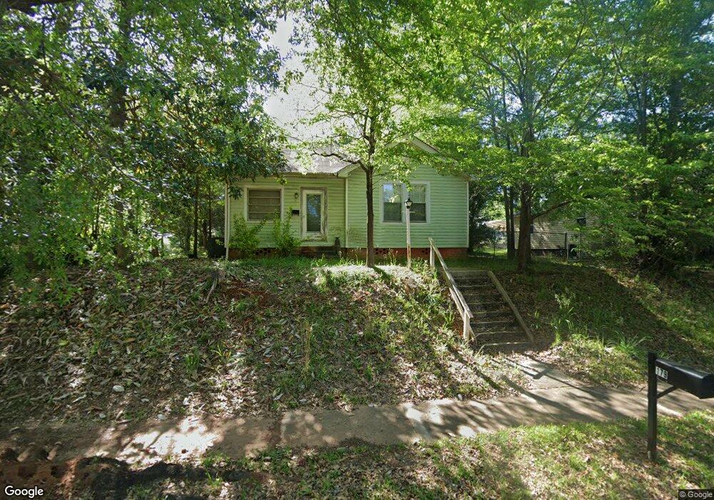
179 R St NW Thomaston, GA 30286
Estimated Value: $152,348 - $179,000
2
Beds
1
Bath
1,280
Sq Ft
$133/Sq Ft
Est. Value
About This Home
This home is located at 179 R St NW, Thomaston, GA 30286 and is currently estimated at $169,837, approximately $132 per square foot. 179 R St NW is a home located in Upson County with nearby schools including Upson-Lee South Elementary School, Upson-Lee North Elementary School, and Upson-Lee Middle School.
Ownership History
Date
Name
Owned For
Owner Type
Purchase Details
Closed on
Feb 23, 2023
Sold by
Salter Terry Bruce
Bought by
Saltey Group Investments Llc
Current Estimated Value
Purchase Details
Closed on
May 5, 2009
Sold by
Pfannkuche Tracy Alan
Bought by
Salter Terry Bruce
Purchase Details
Closed on
Nov 12, 2008
Sold by
Pfannkuche Marie Johnson
Bought by
Pfannkuche Marie Johnson
Create a Home Valuation Report for This Property
The Home Valuation Report is an in-depth analysis detailing your home's value as well as a comparison with similar homes in the area
Home Values in the Area
Average Home Value in this Area
Purchase History
| Date | Buyer | Sale Price | Title Company |
|---|---|---|---|
| Saltey Group Investments Llc | -- | -- | |
| Salter Terry Bruce | $8,125 | -- | |
| Salter Terry Bruce | $8,125 | -- | |
| Salter Terry Bruce | $16,250 | -- | |
| Pfannkuche Marie Johnson | -- | -- |
Source: Public Records
Tax History Compared to Growth
Tax History
| Year | Tax Paid | Tax Assessment Tax Assessment Total Assessment is a certain percentage of the fair market value that is determined by local assessors to be the total taxable value of land and additions on the property. | Land | Improvement |
|---|---|---|---|---|
| 2024 | $1,318 | $43,866 | $10,000 | $33,866 |
| 2023 | $1,318 | $42,715 | $10,000 | $32,715 |
| 2022 | $785 | $28,238 | $6,400 | $21,838 |
| 2021 | $687 | $24,105 | $6,400 | $17,705 |
| 2020 | $735 | $24,116 | $6,800 | $17,316 |
| 2019 | $669 | $21,078 | $4,800 | $16,278 |
| 2018 | $683 | $21,483 | $4,800 | $16,683 |
| 2017 | $431 | $12,325 | $3,200 | $9,125 |
| 2016 | $449 | $12,618 | $3,200 | $9,418 |
| 2015 | $506 | $14,352 | $3,200 | $11,152 |
| 2014 | $507 | $14,352 | $3,200 | $11,152 |
Source: Public Records
Map
Nearby Homes
- 0 9th Ave Unit 10500756
- 146 O St NW
- 105 N St SW
- 104 S St SW
- 213 N St SW
- 920 W Goodrich Ave
- 201 4th Ave SE
- 130 Glenview Way Unit LOT 14
- 3752 N 19 Hwy
- 74 E St
- 109 C St SE
- 8 D St
- 317 4th Ave SE
- 0 Lots On Cottage Ct Unit 1,2,5,7,8,9,10,11,13
- 106 C St NE
- 458 E St
- 114 C St NE
- The Fairmont Plan at Cottages at Silvertown
- The Peachtree Plan at Cottages at Silvertown
- 300 Poplar Dr