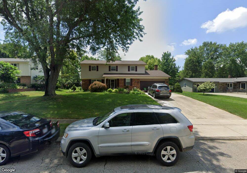
1799 Kempton Dr Columbus, OH 43220
Estimated Value: $549,000 - $714,000
4
Beds
3
Baths
2,368
Sq Ft
$270/Sq Ft
Est. Value
About This Home
This home is located at 1799 Kempton Dr, Columbus, OH 43220 and is currently estimated at $638,762, approximately $269 per square foot. 1799 Kempton Dr is a home located in Franklin County with nearby schools including Greensview Elementary School, Hastings Middle School, and Upper Arlington High School.
Ownership History
Date
Name
Owned For
Owner Type
Purchase Details
Closed on
Aug 2, 1996
Sold by
Taylor Michael B
Bought by
Neff Brad F and Neff Margaret G
Current Estimated Value
Home Financials for this Owner
Home Financials are based on the most recent Mortgage that was taken out on this home.
Original Mortgage
$140,000
Outstanding Balance
$6,370
Interest Rate
7%
Mortgage Type
New Conventional
Estimated Equity
$632,392
Purchase Details
Closed on
Sep 10, 1992
Create a Home Valuation Report for This Property
The Home Valuation Report is an in-depth analysis detailing your home's value as well as a comparison with similar homes in the area
Home Values in the Area
Average Home Value in this Area
Purchase History
| Date | Buyer | Sale Price | Title Company |
|---|---|---|---|
| Neff Brad F | $175,000 | -- | |
| -- | $175,000 | -- |
Source: Public Records
Mortgage History
| Date | Status | Borrower | Loan Amount |
|---|---|---|---|
| Open | Neff Brad F | $140,000 |
Source: Public Records
Tax History
| Year | Tax Paid | Tax Assessment Tax Assessment Total Assessment is a certain percentage of the fair market value that is determined by local assessors to be the total taxable value of land and additions on the property. | Land | Improvement |
|---|---|---|---|---|
| 2025 | $9,971 | $172,240 | $74,100 | $98,140 |
| 2024 | $9,971 | $172,240 | $74,100 | $98,140 |
| 2023 | $9,848 | $172,240 | $74,100 | $98,140 |
| 2022 | $8,714 | $124,710 | $50,090 | $74,620 |
| 2021 | $7,714 | $124,710 | $50,090 | $74,620 |
| 2020 | $7,646 | $124,710 | $50,090 | $74,620 |
| 2019 | $7,133 | $102,870 | $50,090 | $52,780 |
| 2018 | $6,645 | $102,870 | $50,090 | $52,780 |
| 2017 | $7,079 | $102,870 | $50,090 | $52,780 |
| 2016 | $6,203 | $93,810 | $31,890 | $61,920 |
| 2015 | $6,197 | $93,810 | $31,890 | $61,920 |
| 2014 | $6,204 | $93,810 | $31,890 | $61,920 |
| 2013 | $2,962 | $85,260 | $28,980 | $56,280 |
Source: Public Records
Map
Nearby Homes
- 1605 Lafayette Dr Unit 1605
- 1594 Lafayette Dr Unit 1594
- 4803 Wynwood Ct
- 1701 Moreland Dr
- 1916 Willoway Cir S
- 1883 Willoway Cir N Unit 1883
- 1435 Havencrest Ct
- 2158 Sandston Rd
- 4818 Winterset Dr Unit 820
- 2242 Atlee Ct Unit 5
- 1466 Weybridge Rd
- 5109 Ranstead Ct Unit 9
- 5108 Ranstead Ct
- 5107 Delancey St
- 4370 Harborough Rd
- 4305 Castleton Rd
- 2200 Nayland Rd
- 2411 Sheringham Rd
- 5258 Captains Ct Unit E
- 5268 Captains Ct
Your Personal Tour Guide
Ask me questions while you tour the home.