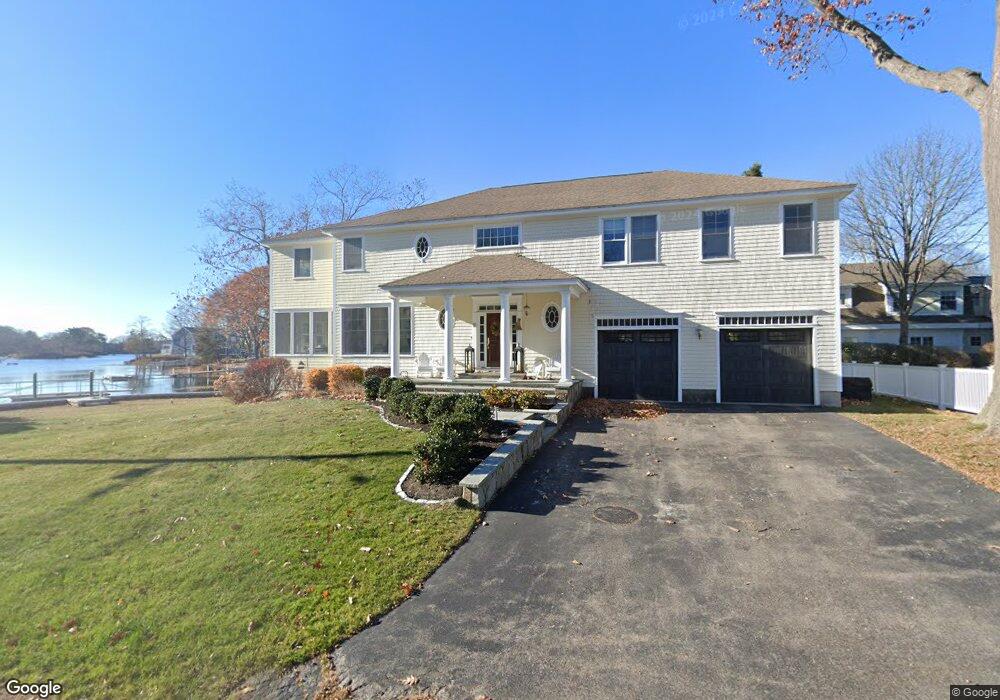
18 Ritson St New Castle, NH 03854
New Castle Island NeighborhoodEstimated Value: $3,440,321 - $4,900,000
5
Beds
4
Baths
4,984
Sq Ft
$829/Sq Ft
Est. Value
About This Home
This home is located at 18 Ritson St, New Castle, NH 03854 and is currently estimated at $4,129,440, approximately $828 per square foot. 18 Ritson St is a home.
Ownership History
Date
Name
Owned For
Owner Type
Purchase Details
Closed on
Feb 13, 2012
Sold by
Hall Nancy L
Bought by
Nancy L Hall Ret
Current Estimated Value
Purchase Details
Closed on
Jan 7, 2004
Sold by
Holt 3Rd Shirley H and Holt Constance L
Bought by
Tischner Stephen
Home Financials for this Owner
Home Financials are based on the most recent Mortgage that was taken out on this home.
Original Mortgage
$760,000
Interest Rate
5.88%
Mortgage Type
Purchase Money Mortgage
Create a Home Valuation Report for This Property
The Home Valuation Report is an in-depth analysis detailing your home's value as well as a comparison with similar homes in the area
Home Values in the Area
Average Home Value in this Area
Purchase History
| Date | Buyer | Sale Price | Title Company |
|---|---|---|---|
| Nancy L Hall Ret | -- | -- | |
| Tischner Stephen | $790,000 | -- |
Source: Public Records
Mortgage History
| Date | Status | Borrower | Loan Amount |
|---|---|---|---|
| Open | Tischner Stephen | $815,000 | |
| Previous Owner | Tischner Stephen | $840,000 | |
| Previous Owner | Tischner Stephen | $760,000 |
Source: Public Records
Tax History Compared to Growth
Tax History
| Year | Tax Paid | Tax Assessment Tax Assessment Total Assessment is a certain percentage of the fair market value that is determined by local assessors to be the total taxable value of land and additions on the property. | Land | Improvement |
|---|---|---|---|---|
| 2024 | $16,864 | $3,128,800 | $2,215,700 | $913,100 |
| 2023 | $15,581 | $3,128,800 | $2,215,700 | $913,100 |
| 2022 | $14,080 | $3,128,800 | $2,215,700 | $913,100 |
| 2021 | $14,894 | $3,116,000 | $2,215,700 | $900,300 |
| 2020 | $11,085 | $1,759,600 | $1,197,300 | $562,300 |
| 2019 | $10,892 | $1,759,600 | $1,197,300 | $562,300 |
| 2018 | $10,558 | $1,759,600 | $1,197,300 | $562,300 |
| 2016 | $10,121 | $1,730,000 | $1,170,300 | $559,700 |
| 2015 | $10,618 | $1,659,000 | $1,069,800 | $589,200 |
| 2014 | $10,949 | $1,659,000 | $1,069,800 | $589,200 |
| 2013 | $10,550 | $1,651,000 | $1,069,800 | $581,200 |
Source: Public Records
Map
Nearby Homes
- 14 Colonial Ln
- 18 Mainmast Cir
- 17 Elm Ct
- 15 Atkinson St
- 175 Wentworth Rd
- 57 Old Bay Rd
- 24 Seabreeze Ln
- 167 Little Harbor Rd
- 163 Little Harbor Rd
- 205 Whipple Rd
- 116 Whipple Rd
- 12 Gillis Dr Unit 3
- 72 Pepperrell Rd
- 112 Wentworth Rd
- 325 Marcy St
- 112 Mechanic St
- 33 Gardner St
- 210 South St
- 405 Pleasant St
- 137 Walker Bungalow Rd
- 43 Portsmouth Ave
- 53 Portsmouth Ave
- 19 Ritson St
- 57 Portsmouth Ave
- 25 Portsmouth Ave
- 131 Davidson St
- 65 Portsmouth Ave
- 44 Portsmouth Ave
- 25 Grist Mill Ln
- 54 Portsmouth Ave
- 67 Locke Rd
- 61 Locke Rd
- 73 Portsmouth Ave
- 62 Portsmouth Ave
- 35 Grist Mill Ln
- 10 Davidson St
- 79 Portsmouth Ave
- 55 Locke Rd
- 34 Oliver St
- 78 Portsmouth Ave