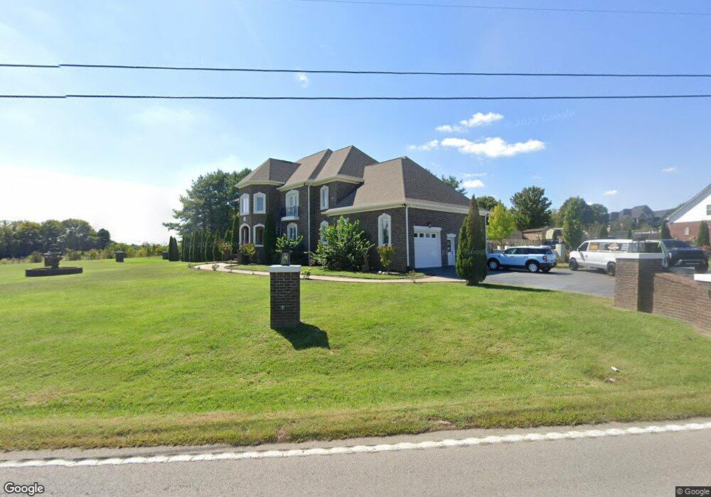
1802 Les Robinson Rd Columbia, TN 38401
Santa Fe NeighborhoodEstimated Value: $1,351,831 - $2,234,000
3
Beds
4
Baths
4,799
Sq Ft
$373/Sq Ft
Est. Value
About This Home
This home is located at 1802 Les Robinson Rd, Columbia, TN 38401 and is currently estimated at $1,789,277, approximately $372 per square foot. 1802 Les Robinson Rd is a home located in Maury County with nearby schools including Spring Hill Elementary School, Spring Hill Middle School, and Spring Hill High School.
Ownership History
Date
Name
Owned For
Owner Type
Purchase Details
Closed on
Dec 31, 2004
Sold by
Mullen Gilley R and Mullen Mona C
Bought by
Mullen Johnnie
Current Estimated Value
Purchase Details
Closed on
Jan 27, 2004
Sold by
Gilliam Larry
Bought by
Mullen Gilley R and Mullen Mona C
Purchase Details
Closed on
Sep 7, 2000
Sold by
Roberts David Dino
Bought by
Gilliam Larry
Create a Home Valuation Report for This Property
The Home Valuation Report is an in-depth analysis detailing your home's value as well as a comparison with similar homes in the area
Home Values in the Area
Average Home Value in this Area
Purchase History
| Date | Buyer | Sale Price | Title Company |
|---|---|---|---|
| Mullen Johnnie | $26,500 | -- | |
| Mullen Gilley R | $30,000 | Heritage Title & Escrow Co I | |
| Gilliam Larry | $24,000 | -- |
Source: Public Records
Tax History Compared to Growth
Tax History
| Year | Tax Paid | Tax Assessment Tax Assessment Total Assessment is a certain percentage of the fair market value that is determined by local assessors to be the total taxable value of land and additions on the property. | Land | Improvement |
|---|---|---|---|---|
| 2024 | $4,391 | $229,875 | $20,000 | $209,875 |
| 2023 | $4,391 | $229,875 | $20,000 | $209,875 |
| 2022 | $4,391 | $229,875 | $20,000 | $209,875 |
| 2021 | $4,391 | $186,550 | $7,500 | $179,050 |
| 2020 | $4,172 | $186,550 | $7,500 | $179,050 |
| 2019 | $4,172 | $186,550 | $7,500 | $179,050 |
| 2018 | $4,172 | $186,550 | $7,500 | $179,050 |
| 2017 | $4,163 | $147,875 | $7,425 | $140,450 |
| 2016 | $4,163 | $147,875 | $7,425 | $140,450 |
| 2015 | $3,874 | $147,875 | $7,425 | $140,450 |
| 2014 | $3,874 | $147,875 | $7,425 | $140,450 |
Source: Public Records
Map
Nearby Homes
- 5679 Carters Creek Pike
- 1909 Doctor Robinson Rd
- 2105 Sue Ln
- 5594 Carters Creek Pike
- CALHOUN Plan at Harvest Point
- BRYAN A Plan at Harvest Point
- EMBRY Plan at Harvest Point
- DOUGLAS A Plan at Harvest Point
- FAYETTE A Plan at Harvest Point
- DIJON B Plan at Harvest Point
- IRWIN A Plan at Harvest Point
- STONEBROOK II Plan at Harvest Point
- Bristol MF Plan at Harvest Point
- TISDALE Plan at Harvest Point
- ANSLEY Plan at Harvest Point
- Clifton MF Plan at Harvest Point
- MILFORD Plan at Harvest Point
- BELFORT Plan at Harvest Point
- HOLDEN Plan at Harvest Point
- DENHAM Plan at Harvest Point
- 1819 Les Robinson Rd
- 1743 Carters Creek Pike
- 1737 Carters Creek Pike
- 1827 Les Robinson Rd
- 1733 Carters Creek Pike
- 1725 Carters Creek Pike
- 1835 Les Robinson Rd
- 1766 Carters Creek Pike
- 1719 Carters Creek Pike
- 1843 Les Robinson Rd
- 1908 Ivy Ct
- 1713 Carters Creek Pike
- 1793 Carters Creek Pike
- 1851 Les Robinson Rd
- 1707 Carters Creek Pike
- 1912 Ivy Ct
- 1904 Ivy Ct
- 1857 Les Robinson Rd
- 1795 Carters Creek Pike
- 1800 Autumn Ln