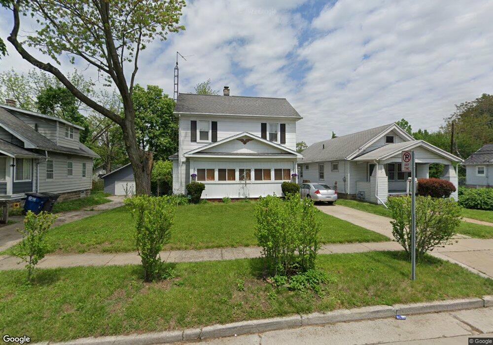
1804 Loxley Rd Toledo, OH 43613
DeVeaux NeighborhoodEstimated Value: $78,000 - $87,000
3
Beds
1
Bath
1,056
Sq Ft
$79/Sq Ft
Est. Value
About This Home
This home is located at 1804 Loxley Rd, Toledo, OH 43613 and is currently estimated at $83,918, approximately $79 per square foot. 1804 Loxley Rd is a home located in Lucas County with nearby schools including DeVeaux Elementary School, Start High School, and Horizon Science Academy - Toledo High School.
Ownership History
Date
Name
Owned For
Owner Type
Purchase Details
Closed on
Nov 18, 2005
Sold by
Papenfuss Doris J and Mcdaniel Doris J
Bought by
Mcdaniel David A and Mcdaniel Doris J
Current Estimated Value
Home Financials for this Owner
Home Financials are based on the most recent Mortgage that was taken out on this home.
Original Mortgage
$53,900
Outstanding Balance
$38,505
Interest Rate
11.65%
Mortgage Type
New Conventional
Estimated Equity
$45,413
Purchase Details
Closed on
May 10, 1991
Sold by
Papenfus Kirk M and Doris J#
Purchase Details
Closed on
Feb 20, 1990
Sold by
Diebe Richard
Create a Home Valuation Report for This Property
The Home Valuation Report is an in-depth analysis detailing your home's value as well as a comparison with similar homes in the area
Home Values in the Area
Average Home Value in this Area
Purchase History
| Date | Buyer | Sale Price | Title Company |
|---|---|---|---|
| Mcdaniel David A | -- | -- | |
| -- | -- | -- | |
| -- | $46,000 | -- |
Source: Public Records
Mortgage History
| Date | Status | Borrower | Loan Amount |
|---|---|---|---|
| Open | Mcdaniel David A | $53,900 |
Source: Public Records
Tax History Compared to Growth
Tax History
| Year | Tax Paid | Tax Assessment Tax Assessment Total Assessment is a certain percentage of the fair market value that is determined by local assessors to be the total taxable value of land and additions on the property. | Land | Improvement |
|---|---|---|---|---|
| 2024 | $295 | $16,800 | $6,405 | $10,395 |
| 2023 | $1,032 | $15,155 | $5,250 | $9,905 |
| 2022 | $1,036 | $15,155 | $5,250 | $9,905 |
| 2021 | $1,057 | $15,155 | $5,250 | $9,905 |
| 2020 | $1,142 | $14,490 | $4,970 | $9,520 |
| 2019 | $1,106 | $14,490 | $4,970 | $9,520 |
| 2018 | $1,114 | $14,490 | $4,970 | $9,520 |
| 2017 | $1,138 | $14,175 | $4,865 | $9,310 |
| 2016 | $1,145 | $40,500 | $13,900 | $26,600 |
| 2015 | $1,137 | $40,500 | $13,900 | $26,600 |
| 2014 | $892 | $14,180 | $4,870 | $9,310 |
| 2013 | $892 | $14,180 | $4,870 | $9,310 |
Source: Public Records
Map
Nearby Homes
- 1759 Talbot St
- 1840 Talbot St
- 1814 Balkan Place
- 1749 Berdan Ave
- 3430 Upton Ave
- 1815 Berdan Ave
- 1846 Balkan Place
- 1822 Wychwood St
- 1735 Wychwood St
- 1834 Berdan Ave
- 1935 Talbot St
- 1929 Marlow Rd
- 1741 Barrows St
- 1939 Balkan Place
- 3821 Jackman Rd
- 1818 Barrows St
- 1820 Barrows St
- 1747 Duncan Rd
- 1952 Fairfax Rd
- 1820 Marne Ave