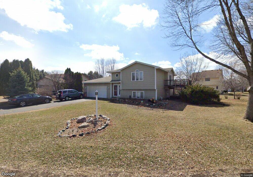
1804 Ruby Cir Shakopee, MN 55379
Estimated Value: $365,780 - $397,000
4
Beds
2
Baths
1,000
Sq Ft
$379/Sq Ft
Est. Value
About This Home
This home is located at 1804 Ruby Cir, Shakopee, MN 55379 and is currently estimated at $379,445, approximately $379 per square foot. 1804 Ruby Cir is a home located in Scott County with nearby schools including Sun Path Elementary School, Shakopee West Middle School, and Shakopee Senior High School.
Ownership History
Date
Name
Owned For
Owner Type
Purchase Details
Closed on
Aug 22, 2016
Sold by
Lint Adam T and Lint Jaime
Bought by
Sdoeung Sokmany and Sdoeung Teaery
Current Estimated Value
Home Financials for this Owner
Home Financials are based on the most recent Mortgage that was taken out on this home.
Original Mortgage
$245,471
Outstanding Balance
$195,159
Interest Rate
3.37%
Mortgage Type
FHA
Estimated Equity
$184,286
Purchase Details
Closed on
Jun 28, 2004
Sold by
Leonhardt Thomas A and Leonhardt Tori A
Bought by
Vizal Joshua M and Lint Adam
Create a Home Valuation Report for This Property
The Home Valuation Report is an in-depth analysis detailing your home's value as well as a comparison with similar homes in the area
Home Values in the Area
Average Home Value in this Area
Purchase History
| Date | Buyer | Sale Price | Title Company |
|---|---|---|---|
| Sdoeung Sokmany | $251,000 | Executive Title | |
| Vizal Joshua M | $235,000 | -- |
Source: Public Records
Mortgage History
| Date | Status | Borrower | Loan Amount |
|---|---|---|---|
| Open | Sdoeung Sokmany | $245,471 |
Source: Public Records
Tax History Compared to Growth
Tax History
| Year | Tax Paid | Tax Assessment Tax Assessment Total Assessment is a certain percentage of the fair market value that is determined by local assessors to be the total taxable value of land and additions on the property. | Land | Improvement |
|---|---|---|---|---|
| 2025 | $3,430 | $337,600 | $174,100 | $163,500 |
| 2024 | $3,492 | $338,500 | $174,100 | $164,400 |
| 2023 | $3,696 | $332,100 | $169,700 | $162,400 |
| 2022 | $3,516 | $344,800 | $169,700 | $175,100 |
| 2021 | $3,040 | $286,000 | $137,000 | $149,000 |
| 2020 | $3,158 | $272,700 | $122,900 | $149,800 |
| 2019 | $3,092 | $251,800 | $103,000 | $148,800 |
| 2018 | $2,848 | $0 | $0 | $0 |
| 2016 | $3,012 | $0 | $0 | $0 |
| 2014 | -- | $0 | $0 | $0 |
Source: Public Records
Map
Nearby Homes
- 2312 Vierling Dr E
- 1164 Merrifield Ct
- 2388 Vierling Dr E
- 1933 Davis Ct
- 1552 Dublin Ct
- 1820 Mockingbird Ave
- 1844 Mockingbird Ave Unit 1102
- 2263 Tyrone Dr
- 1076 Sibley St S
- 2399 Tyrone Dr
- 2447 Tyrone Dr
- 1511 England Way
- 2471 Tyrone Dr
- 1775 Hauer Trail
- 2006 Tyrone Dr
- 1130 Farrier Rd
- 2585 Paddock Path
- Lewis Plan at Summerland Place - Landmark Collection
- 2795 Downing Ave
- Vanderbilt Plan at Summerland Place - Landmark Collection