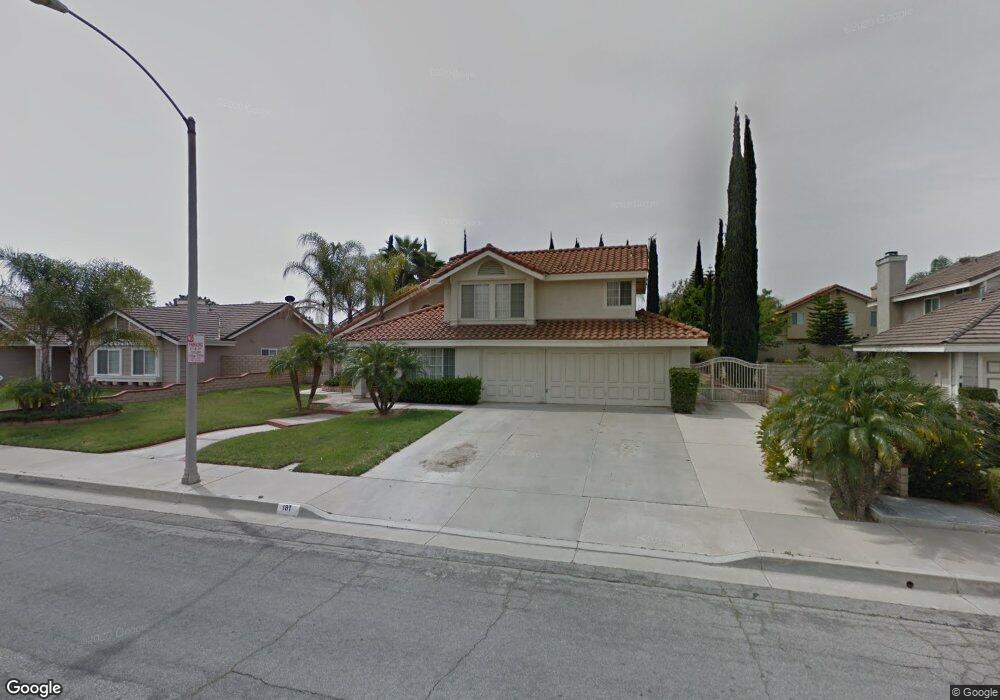
181 Cannon Rd Riverside, CA 92506
Mission Grove NeighborhoodEstimated Value: $704,000 - $914,000
4
Beds
3
Baths
2,550
Sq Ft
$314/Sq Ft
Est. Value
About This Home
This home is located at 181 Cannon Rd, Riverside, CA 92506 and is currently estimated at $801,108, approximately $314 per square foot. 181 Cannon Rd is a home located in Riverside County with nearby schools including William Howard Taft Elementary School, Amelia Earhart Middle School, and Martin Luther King Junior High School.
Ownership History
Date
Name
Owned For
Owner Type
Purchase Details
Closed on
Jan 28, 2005
Sold by
Hatcher Imogene M and Hatcher Phyllis P
Bought by
Hatcher Timothy J
Current Estimated Value
Home Financials for this Owner
Home Financials are based on the most recent Mortgage that was taken out on this home.
Original Mortgage
$125,000
Interest Rate
5.37%
Mortgage Type
Purchase Money Mortgage
Create a Home Valuation Report for This Property
The Home Valuation Report is an in-depth analysis detailing your home's value as well as a comparison with similar homes in the area
Home Values in the Area
Average Home Value in this Area
Purchase History
| Date | Buyer | Sale Price | Title Company |
|---|---|---|---|
| Hatcher Timothy J | -- | Orange Coast Title |
Source: Public Records
Mortgage History
| Date | Status | Borrower | Loan Amount |
|---|---|---|---|
| Closed | Hatcher Timothy J | $125,000 |
Source: Public Records
Tax History
| Year | Tax Paid | Tax Assessment Tax Assessment Total Assessment is a certain percentage of the fair market value that is determined by local assessors to be the total taxable value of land and additions on the property. | Land | Improvement |
|---|---|---|---|---|
| 2025 | $6,306 | $588,695 | $111,954 | $476,741 |
| 2023 | $6,306 | $565,837 | $107,607 | $458,230 |
| 2022 | $6,159 | $554,744 | $105,498 | $449,246 |
| 2021 | $6,072 | $543,868 | $103,430 | $440,438 |
| 2020 | $6,026 | $538,292 | $102,370 | $435,922 |
| 2019 | $5,911 | $527,738 | $100,363 | $427,375 |
| 2018 | $5,794 | $517,392 | $98,396 | $418,996 |
| 2017 | $5,373 | $479,000 | $91,000 | $388,000 |
| 2016 | $4,634 | $433,000 | $82,000 | $351,000 |
| 2015 | $4,765 | $445,000 | $85,000 | $360,000 |
| 2014 | $4,565 | $421,000 | $80,000 | $341,000 |
Source: Public Records
Map
Nearby Homes
- 7130 Tiverton Way
- 200 E Alessandro Blvd Unit 79
- 200 E Alessandro Blvd Unit 34
- 200 E Alessandro Blvd Unit 94
- 7320 Barnstable Place
- 276 Cottonwood Ave
- 901 Clearwood Ave
- 6746 Alderpoint Ct
- 6721 Silver Oak Place
- 19121 Broken Bow Dr
- 7639 Hillhurst Dr
- 7158 Golden Vale Dr
- 1087 Mission Grove Pkwy N
- 1202 Villanova Place
- 6568 Balzac Cir
- 7007 Golden Vale Dr
- 19156 Zamora Way
- 6910 Sandtrack Rd
- 6801 Rycroft Dr
- 14420 Merlot Ct
- 173 Cannon Rd
- 189 Cannon Rd
- 7166 Westport St
- 7158 Westport St
- 7174 Westport St
- 176 Cannon Rd
- 165 Cannon Rd
- 184 Cannon Rd
- 203 Cannon Rd
- 7150 Westport St
- 168 Cannon Rd
- 7182 Westport St
- 214 Bathurst Rd
- 157 Cannon Rd
- 160 Cannon Rd
- 211 Cannon Rd
- 201 Bathurst Rd
- 7142 Westport St
- 7190 Westport St
- 143 Fife Ct
Your Personal Tour Guide
Ask me questions while you tour the home.