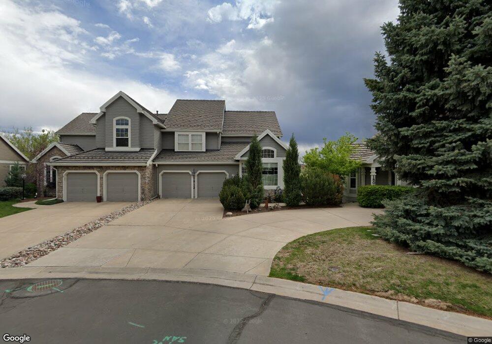
1812 W Cape Cod Way Littleton, CO 80120
South Littleton NeighborhoodEstimated Value: $751,905 - $1,029,000
2
Beds
4
Baths
2,833
Sq Ft
$307/Sq Ft
Est. Value
About This Home
This home is located at 1812 W Cape Cod Way, Littleton, CO 80120 and is currently estimated at $870,976, approximately $307 per square foot. 1812 W Cape Cod Way is a home located in Arapahoe County with nearby schools including Runyon Elementary School, Euclid Middle School, and Heritage High School.
Ownership History
Date
Name
Owned For
Owner Type
Purchase Details
Closed on
Mar 31, 2025
Sold by
Udziela Robert A and Livi Rita
Bought by
Robert A Udziela Marital Trust and Rita B Udziela Survivors Trust
Current Estimated Value
Purchase Details
Closed on
Sep 19, 2007
Sold by
Udziela Robert A and Udziela Rita B
Bought by
Robert A & Rita B Udziela Living Trust
Purchase Details
Closed on
Sep 10, 2007
Sold by
The Peninsula Trust
Bought by
Udziela Robert A and Udziela Rita B
Purchase Details
Closed on
Jan 13, 1998
Sold by
Writer Peninsula Inc
Bought by
Udziela Robert A and Udziela Rita B
Create a Home Valuation Report for This Property
The Home Valuation Report is an in-depth analysis detailing your home's value as well as a comparison with similar homes in the area
Home Values in the Area
Average Home Value in this Area
Purchase History
| Date | Buyer | Sale Price | Title Company |
|---|---|---|---|
| Robert A Udziela Marital Trust | -- | None Listed On Document | |
| Robert A & Rita B Udziela Living Trust | -- | None Available | |
| Udziela Robert A | -- | None Available | |
| Udziela Robert A | $420,686 | Land Title |
Source: Public Records
Tax History Compared to Growth
Tax History
| Year | Tax Paid | Tax Assessment Tax Assessment Total Assessment is a certain percentage of the fair market value that is determined by local assessors to be the total taxable value of land and additions on the property. | Land | Improvement |
|---|---|---|---|---|
| 2024 | $4,796 | $56,856 | -- | -- |
| 2023 | $4,796 | $56,856 | $0 | $0 |
| 2022 | $5,108 | $57,262 | $0 | $0 |
| 2021 | $5,094 | $57,262 | $0 | $0 |
| 2020 | $5,088 | $58,866 | $0 | $0 |
| 2019 | $4,787 | $58,866 | $0 | $0 |
| 2018 | $4,046 | $53,662 | $0 | $0 |
| 2017 | $3,749 | $53,662 | $0 | $0 |
| 2016 | $3,768 | $52,815 | $0 | $0 |
| 2015 | $3,777 | $52,815 | $0 | $0 |
| 2014 | -- | $45,125 | $0 | $0 |
| 2013 | -- | $45,980 | $0 | $0 |
Source: Public Records
Map
Nearby Homes
- 1651 W Canal Cir Unit 631
- 1672 W Canal Cir Unit 412
- 1632 W Canal Cir Unit 915
- 1631 W Canal Cir Unit 832
- 1631 W Canal Cir Unit 817
- 7840 S Windermere Cir
- 8403 Rizza St Unit B
- 7909 S Bemis St
- 8387 Donati Terrace Unit B
- 8387 Donati Terrace Unit A
- 8417 Rizza St Unit A
- 8376 Lorenzo Ln Unit A
- 2225 Santini Trail Unit C
- 2220 Santini Trail Unit A
- 2597 Channel Dr
- 8332 Rivulet Point
- 8338 Rivulet Point
- 2649 Channel Dr
- 7705 S Hill Dr
- 7724 S Nevada Dr
- 1814 W Cape Cod Way
- 1804 W Cape Cod Way
- 1822 W Cape Cod Way
- 1802 W Cape Cod Way
- 1824 W Cape Cod Way
- 8282 S Peninsula Dr
- 8292 S Peninsula Dr
- 8272 S Peninsula Dr
- 1832 W Cape Cod Way
- 8302 S Peninsula Dr
- 8262 S Peninsula Dr
- 8304 S Peninsula Dr
- 8291 S Peninsula Dr
- 1834 W Cape Cod Way
- 8281 S Peninsula Dr
- 8271 S Peninsula Dr
- 8261 S Peninsula Dr
- 8252 S Peninsula Dr
- 1842 W Cape Cod Way
- 8251 S Peninsula Dr