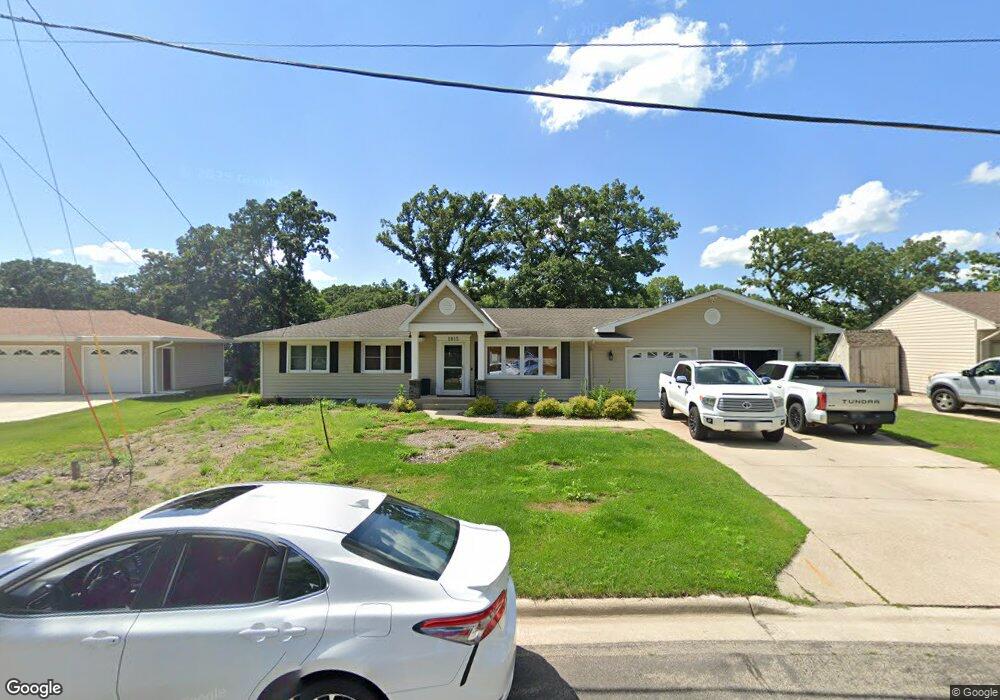
1815 Brookside Cir Albert Lea, MN 56007
Estimated Value: $317,000 - $372,000
3
Beds
3
Baths
1,756
Sq Ft
$198/Sq Ft
Est. Value
About This Home
This home is located at 1815 Brookside Cir, Albert Lea, MN 56007 and is currently estimated at $347,524, approximately $197 per square foot. 1815 Brookside Cir is a home located in Freeborn County with nearby schools including Lakeview Elementary School, Southwest Middle School, and Albert Lea Senior High School.
Ownership History
Date
Name
Owned For
Owner Type
Purchase Details
Closed on
Aug 29, 2019
Sold by
Dickerman Robert F and Dickerman Ana M
Bought by
Quinlivan Joshua B and Meaney Morgan M
Current Estimated Value
Home Financials for this Owner
Home Financials are based on the most recent Mortgage that was taken out on this home.
Original Mortgage
$204,000
Outstanding Balance
$179,053
Interest Rate
3.7%
Mortgage Type
New Conventional
Estimated Equity
$168,471
Create a Home Valuation Report for This Property
The Home Valuation Report is an in-depth analysis detailing your home's value as well as a comparison with similar homes in the area
Home Values in the Area
Average Home Value in this Area
Purchase History
| Date | Buyer | Sale Price | Title Company |
|---|---|---|---|
| Quinlivan Joshua B | $314,000 | None Available |
Source: Public Records
Mortgage History
| Date | Status | Borrower | Loan Amount |
|---|---|---|---|
| Open | Quinlivan Joshua B | $204,000 |
Source: Public Records
Tax History
| Year | Tax Paid | Tax Assessment Tax Assessment Total Assessment is a certain percentage of the fair market value that is determined by local assessors to be the total taxable value of land and additions on the property. | Land | Improvement |
|---|---|---|---|---|
| 2025 | $4,902 | $349,700 | $63,800 | $285,900 |
| 2024 | $4,892 | $329,100 | $63,800 | $265,300 |
| 2023 | $4,388 | $329,800 | $63,800 | $266,000 |
| 2021 | $4,108 | $247,200 | $51,000 | $196,200 |
| 2020 | $3,840 | $228,600 | $51,000 | $177,600 |
| 2019 | $3,514 | $213,100 | $51,000 | $162,100 |
| 2018 | $3,422 | $0 | $0 | $0 |
| 2016 | $3,074 | $0 | $0 | $0 |
| 2015 | $3,010 | $0 | $0 | $0 |
| 2014 | $3,022 | $0 | $0 | $0 |
| 2012 | $3,438 | $0 | $0 | $0 |
Source: Public Records
Map
Nearby Homes
- 1814 Brookside Cir
- 1807 Brookside Dr
- 418 Ridge Rd
- 319 Garden Rd
- 404 Garden Rd
- 1823 Lakewood Ave Unit 2
- 314 Garden Rd
- 1805 Lakewood Ave
- 1310 W Richway Dr
- 1932 Wilby Rd
- 120 Ridge Rd
- 210 Lee Place
- 307 E Richway Dr
- 1609 Country Club Rd
- 313 Glenn Rd
- 319 Glenn Rd
- 1626 Keystone Dr
- 105 E Hawthorne St
- 1409 Circle Dr
- 705 Glenview Dr
- 1817 Brookside Cir
- 1813 Brookside Cir
- 1819 Brookside Cir
- 1816 Brookside Cir
- 1811 Brookside Cir
- 1818 Brookside Cir
- 1821 Brookside Cir
- 1820 Brookside Cir
- 1809 Brookside Cir
- 1014 Shore Acres Dr
- 1010 Shore Acres Dr
- 1807 Brookside Cir
- 1811 Brookside Dr
- 1806 Brookside Cir
- 1815 Brookside Dr
- 1823 Brookside Cir
- 1824 Brookside Cir
- 1006 Shore Acres Dr
- 622 W Richway Dr
- 1805 Brookside Cir
Your Personal Tour Guide
Ask me questions while you tour the home.