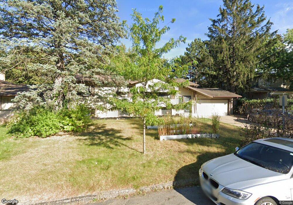
182 Faye St Saint Paul, MN 55119
Battle Creek NeighborhoodEstimated Value: $320,588 - $347,000
4
Beds
2
Baths
1,954
Sq Ft
$170/Sq Ft
Est. Value
About This Home
This home is located at 182 Faye St, Saint Paul, MN 55119 and is currently estimated at $332,647, approximately $170 per square foot. 182 Faye St is a home located in Ramsey County with nearby schools including Battle Creek Elementary School, Battle Creek Middle School, and Harding Senior High School.
Ownership History
Date
Name
Owned For
Owner Type
Purchase Details
Closed on
Jul 29, 2021
Sold by
Miller Brett J and Miller Jennifer
Bought by
Richardson Gabriel
Current Estimated Value
Home Financials for this Owner
Home Financials are based on the most recent Mortgage that was taken out on this home.
Original Mortgage
$266,750
Outstanding Balance
$242,667
Interest Rate
2.93%
Mortgage Type
New Conventional
Estimated Equity
$89,980
Purchase Details
Closed on
Jun 7, 2002
Sold by
Boler Marie and Boler Daniel
Bought by
Miller Brett J
Purchase Details
Closed on
Mar 13, 1998
Sold by
Estate Of Kenneth J Ruehle
Bought by
Boler Daniel D and Boler Simona N
Create a Home Valuation Report for This Property
The Home Valuation Report is an in-depth analysis detailing your home's value as well as a comparison with similar homes in the area
Home Values in the Area
Average Home Value in this Area
Purchase History
| Date | Buyer | Sale Price | Title Company |
|---|---|---|---|
| Richardson Gabriel | $275,000 | Edgewater Title | |
| Miller Brett J | $198,000 | -- | |
| Boler Daniel D | $121,000 | -- | |
| Richardson Gabriel Gabriel | $275,000 | -- |
Source: Public Records
Mortgage History
| Date | Status | Borrower | Loan Amount |
|---|---|---|---|
| Open | Richardson Gabriel | $266,750 | |
| Closed | Richardson Gabriel Gabriel | $266,750 |
Source: Public Records
Tax History Compared to Growth
Tax History
| Year | Tax Paid | Tax Assessment Tax Assessment Total Assessment is a certain percentage of the fair market value that is determined by local assessors to be the total taxable value of land and additions on the property. | Land | Improvement |
|---|---|---|---|---|
| 2025 | $4,084 | $256,400 | $41,800 | $214,600 |
| 2023 | $4,084 | $271,700 | $41,800 | $229,900 |
| 2022 | $4,208 | $265,500 | $41,800 | $223,700 |
| 2021 | $3,976 | $269,300 | $41,800 | $227,500 |
| 2020 | $3,966 | $260,900 | $41,800 | $219,100 |
| 2019 | $4,030 | $243,700 | $41,800 | $201,900 |
| 2018 | $3,414 | $246,900 | $41,800 | $205,100 |
| 2017 | $3,232 | $211,400 | $36,800 | $174,600 |
| 2016 | $3,196 | $0 | $0 | $0 |
| 2015 | $3,234 | $189,600 | $36,800 | $152,800 |
| 2014 | $2,854 | $0 | $0 | $0 |
Source: Public Records
Map
Nearby Homes
- 125 Battle Creek Place
- 1935 Warbler Ln
- 136 White Bear Ave N
- 49 Battle Creek Place
- 1989 N Park Dr
- 138 Ruth St N Unit 9
- 2059 Parkside Dr Unit 29
- 2063 N Park Dr Unit 6
- 2069 Parkside Dr Unit G2
- 1821 Wilson Ave
- 237 Sigurd St
- 267 Hazelwood St
- 465 Ruth St N
- 1600 Old Hudson Rd
- 201 Dora Ct W
- 125 Mcknight Rd N Unit K
- 2219 Cardinal Place
- 1935 Fremont Ave E
- 1964 4th St E
- 1538 Wilson Ave