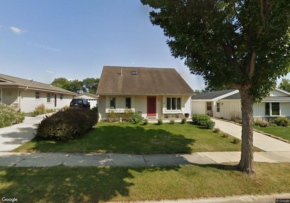
1821 Michael Dr Waukesha, WI 53189
Estimated Value: $357,000 - $440,000
3
Beds
2
Baths
1,587
Sq Ft
$256/Sq Ft
Est. Value
About This Home
This home is located at 1821 Michael Dr, Waukesha, WI 53189 and is currently estimated at $406,495, approximately $256 per square foot. 1821 Michael Dr is a home located in Waukesha County with nearby schools including Waukesha STEM Academy, Horning Middle School, and South High School.
Ownership History
Date
Name
Owned For
Owner Type
Purchase Details
Closed on
Apr 28, 2006
Sold by
Kimmel Daniel M and Kimmel Sharon C
Bought by
Laudermilk Kevin and Tetzlaff Valerie J
Current Estimated Value
Home Financials for this Owner
Home Financials are based on the most recent Mortgage that was taken out on this home.
Original Mortgage
$160,000
Interest Rate
6.66%
Mortgage Type
Fannie Mae Freddie Mac
Purchase Details
Closed on
Jul 1, 2003
Sold by
Kimmel Daniel M and Crooke Sharon L
Bought by
Kimmel Daniel M and Kimmel Sharon C
Home Financials for this Owner
Home Financials are based on the most recent Mortgage that was taken out on this home.
Original Mortgage
$115,000
Interest Rate
5.36%
Mortgage Type
Purchase Money Mortgage
Purchase Details
Closed on
Sep 29, 2000
Sold by
Tompkins Gary K and Tompkins Diane L
Bought by
Kimmel Daniel M and Crooke Sharon L
Create a Home Valuation Report for This Property
The Home Valuation Report is an in-depth analysis detailing your home's value as well as a comparison with similar homes in the area
Home Values in the Area
Average Home Value in this Area
Purchase History
| Date | Buyer | Sale Price | Title Company |
|---|---|---|---|
| Laudermilk Kevin | $218,000 | None Available | |
| Kimmel Daniel M | -- | -- | |
| Kimmel Daniel M | $152,000 | -- |
Source: Public Records
Mortgage History
| Date | Status | Borrower | Loan Amount |
|---|---|---|---|
| Previous Owner | Laudermilk Kevin | $160,000 | |
| Previous Owner | Kimmel Daniel M | $115,000 |
Source: Public Records
Tax History Compared to Growth
Tax History
| Year | Tax Paid | Tax Assessment Tax Assessment Total Assessment is a certain percentage of the fair market value that is determined by local assessors to be the total taxable value of land and additions on the property. | Land | Improvement |
|---|---|---|---|---|
| 2024 | $5,041 | $339,500 | $56,100 | $283,400 |
| 2023 | $4,902 | $339,500 | $56,100 | $283,400 |
| 2022 | $4,139 | $217,100 | $44,600 | $172,500 |
| 2021 | $4,234 | $217,100 | $44,600 | $172,500 |
| 2020 | $4,096 | $217,100 | $44,600 | $172,500 |
| 2019 | $3,966 | $217,100 | $44,600 | $172,500 |
| 2018 | $3,641 | $195,600 | $39,600 | $156,000 |
| 2017 | $3,635 | $195,600 | $39,600 | $156,000 |
| 2016 | $3,766 | $189,900 | $39,600 | $150,300 |
| 2015 | $3,744 | $189,900 | $39,600 | $150,300 |
| 2014 | $3,788 | $184,400 | $39,600 | $144,800 |
| 2013 | $3,788 | $184,400 | $39,600 | $144,800 |
Source: Public Records
Map
Nearby Homes
- 1906 Marliz Dr
- 414 Standing Stone Dr Unit 8-16
- 412 Standing Stone Dr Unit 8-15
- 421 Standing Stone Dr Unit 17-39
- 424 Standing Stone Dr Unit 9-17
- 2004 Smart Ct
- 2005 Smart Ct
- 2017 Smart Ct
- 435 Standing Stone Dr Unit 16-37
- 455 Standing Stone Dr
- 300 Darlene Dr
- The Cypress Plan at The Glen at Standing Stone
- The Hawthorne Plan at The Glen at Standing Stone
- The Holly Plan at The Glen at Standing Stone
- The Juniper Plan at The Glen at Standing Stone
- The Laurel Plan at The Glen at Standing Stone
- The Willow Plan at The Glen at Standing Stone
- The Tartan Plan at The Glen at Standing Stone
- The Kenzie Plan at The Glen at Standing Stone
- The Calli Plan at The Glen at Standing Stone
- 1901 Michael Dr
- 1817 Michael Dr
- 1815 Michael Dr
- 1809 Michael Dr
- 1909 Michael Dr
- 1820 Michael Dr
- 1816 Michael Dr
- 1900 Michael Dr
- 1904 Michael Dr
- 1812 Michael Dr
- 109 Rivera Dr
- 115 Rivera Dr
- 1808 Michael Dr
- 1805 Michael Dr
- 1908 Michael Dr
- 1908 Cliff Alex Ct N
- 1904 Cliff Alex Ct N
- 1804 Michael Dr
- 1912 Cliff Alex Ct N
- 1801 Michael Dr