Estimated Value: $332,893 - $372,000
4
Beds
2
Baths
2,300
Sq Ft
$153/Sq Ft
Est. Value
About This Home
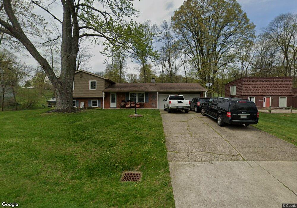
This home is located at 1824 Pine Rd, Heath, OH 43056 and is currently estimated at $351,473, approximately $152 per square foot. 1824 Pine Rd is a home located in Licking County with nearby schools including Garfield Elementary School, Stevenson Elementary School, and Heath Middle School.
Ownership History
Date
Name
Owned For
Owner Type
Purchase Details
Closed on
Feb 26, 2015
Sold by
Fiberglas Fcu
Bought by
Maynard Bill R and Maynard Carol S
Current Estimated Value
Home Financials for this Owner
Home Financials are based on the most recent Mortgage that was taken out on this home.
Original Mortgage
$99,750
Interest Rate
3.64%
Mortgage Type
Unknown
Purchase Details
Closed on
Jul 29, 2014
Sold by
Willey James and Willey Lisa
Bought by
Fiberglas Federal Credit Union
Purchase Details
Closed on
Nov 7, 2007
Sold by
Bush Rachel
Bought by
Willey James and Willey Lisa
Purchase Details
Closed on
Jan 30, 2006
Sold by
Willey James P and Willey Lisa M
Bought by
Bush Rachel and 1824 Pine Rd Estate Planning Trust
Create a Home Valuation Report for This Property
The Home Valuation Report is an in-depth analysis detailing your home's value as well as a comparison with similar homes in the area
Home Values in the Area
Average Home Value in this Area
Purchase History
| Date | Buyer | Sale Price | Title Company |
|---|---|---|---|
| Maynard Bill R | $157,500 | None Available | |
| Fiberglas Federal Credit Union | -- | None Available | |
| Willey James | -- | None Available | |
| Bush Rachel | $137,100 | Supreme Title Agency |
Source: Public Records
Mortgage History
| Date | Status | Borrower | Loan Amount |
|---|---|---|---|
| Previous Owner | Maynard Bill R | $99,750 |
Source: Public Records
Tax History
| Year | Tax Paid | Tax Assessment Tax Assessment Total Assessment is a certain percentage of the fair market value that is determined by local assessors to be the total taxable value of land and additions on the property. | Land | Improvement |
|---|---|---|---|---|
| 2024 | $3,737 | $85,160 | $20,690 | $64,470 |
| 2023 | $4,139 | $85,160 | $20,690 | $64,470 |
| 2022 | $3,063 | $55,380 | $12,080 | $43,300 |
| 2021 | $3,126 | $55,380 | $12,080 | $43,300 |
| 2020 | $3,146 | $55,380 | $12,080 | $43,300 |
| 2019 | $2,780 | $49,740 | $12,080 | $37,660 |
| 2018 | $2,748 | $0 | $0 | $0 |
| 2017 | $2,755 | $0 | $0 | $0 |
| 2016 | $2,657 | $0 | $0 | $0 |
| 2015 | $2,763 | $0 | $0 | $0 |
| 2014 | $3,800 | $0 | $0 | $0 |
| 2013 | $2,553 | $0 | $0 | $0 |
Source: Public Records
Map
Nearby Homes
- 1933 Blue Jay Rd
- 0 Cumberland Crest
- 1782 Cumberland Crest
- 5185 Linnville Rd
- 748 Francis Dr
- 722 Francis Dr
- 719 Francis Dr
- 731 Francis Dr
- 1307 Kacey Ct
- 767 Francis Dr
- 730 Francis Dr
- 621 S 2nd St
- 9246 Summit Rd SE
- 121 Isabelle Rd
- 364 W National Dr
- 870 Jones St
- 164 Orchard St
- 351 Barclay St
- 150 Linnridge Dr Unit Lot 28
- 146 Linnridge Dr Unit Lot 27
Your Personal Tour Guide
Ask me questions while you tour the home.