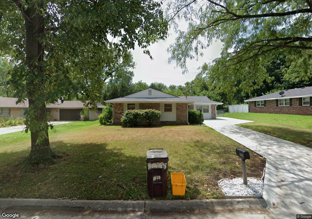
1824 Vaughn Dr Manhattan, KS 66502
West Campus NeighborhoodEstimated Value: $219,752 - $248,000
3
Beds
2
Baths
1,545
Sq Ft
$148/Sq Ft
Est. Value
About This Home
This home is located at 1824 Vaughn Dr, Manhattan, KS 66502 and is currently estimated at $228,438, approximately $147 per square foot. 1824 Vaughn Dr is a home located in Riley County with nearby schools including Marlatt Elementary School, Susan B. Anthony Middle School, and Manhattan High School.
Ownership History
Date
Name
Owned For
Owner Type
Purchase Details
Closed on
Feb 5, 2021
Sold by
Able Bill V
Bought by
Sier William J and Sier Mary L
Current Estimated Value
Home Financials for this Owner
Home Financials are based on the most recent Mortgage that was taken out on this home.
Original Mortgage
$150,000
Outstanding Balance
$134,159
Interest Rate
2.7%
Mortgage Type
VA
Estimated Equity
$94,279
Purchase Details
Closed on
Sep 22, 2017
Sold by
Able Bill V
Bought by
Able Bill V and Able Douglas K
Create a Home Valuation Report for This Property
The Home Valuation Report is an in-depth analysis detailing your home's value as well as a comparison with similar homes in the area
Home Values in the Area
Average Home Value in this Area
Purchase History
| Date | Buyer | Sale Price | Title Company |
|---|---|---|---|
| Sier William J | $147,000 | -- | |
| Able Bill V | -- | -- |
Source: Public Records
Mortgage History
| Date | Status | Borrower | Loan Amount |
|---|---|---|---|
| Open | Sier William J | $150,000 |
Source: Public Records
Tax History Compared to Growth
Tax History
| Year | Tax Paid | Tax Assessment Tax Assessment Total Assessment is a certain percentage of the fair market value that is determined by local assessors to be the total taxable value of land and additions on the property. | Land | Improvement |
|---|---|---|---|---|
| 2025 | $2,982 | $21,712 | $3,533 | $18,179 |
| 2024 | $2,982 | $20,665 | $3,412 | $17,253 |
| 2023 | $2,834 | $19,492 | $3,269 | $16,223 |
| 2022 | $2,605 | $17,239 | $3,248 | $13,991 |
| 2021 | $2,663 | $17,136 | $3,278 | $13,858 |
| 2020 | $2,641 | $17,308 | $3,287 | $14,021 |
| 2019 | $2,663 | $17,308 | $3,287 | $14,021 |
| 2018 | $2,555 | $17,509 | $3,372 | $14,137 |
| 2017 | $2,493 | $17,509 | $2,945 | $14,564 |
| 2016 | $2,564 | $18,143 | $2,477 | $15,666 |
| 2014 | -- | $0 | $0 | $0 |
Source: Public Records
Map
Nearby Homes
- 1820 Cassell Rd
- 1737 Kenmar Dr
- 1720 Ranser Rd
- 2445 Hobbs Dr
- 2411 Woodway Dr Unit A
- 2411 Woodway Dr Unit K
- 2018 Browning Ave
- 2020 Browning Ave
- 2847 Oregon Ln
- 2129 Tamarron Terrace
- 3127 Ella Ln
- 1511 Campus Dr
- 3009 Claflin Rd
- 1408 Nichols St
- 2331 Cheryl Terrace
- 2215 Terry Way
- 3209 Gary Ave
- 3220 Gary Ave
- 2047 College View Rd
- 3217 Park Cir