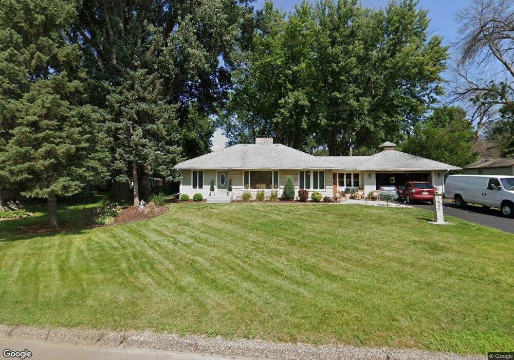
1830 Prosperity Rd Saint Paul, MN 55109
Gladstone NeighborhoodEstimated Value: $328,000 - $357,279
2
Beds
2
Baths
444
Sq Ft
$758/Sq Ft
Est. Value
About This Home
This home is located at 1830 Prosperity Rd, Saint Paul, MN 55109 and is currently estimated at $336,570, approximately $758 per square foot. 1830 Prosperity Rd is a home located in Ramsey County with nearby schools including Weaver Elementary School, John Glenn Middle School, and Mounds Park Academy.
Ownership History
Date
Name
Owned For
Owner Type
Purchase Details
Closed on
Sep 9, 2016
Sold by
Melde Dan J and Melde Kathryn T
Bought by
Melde Dan J and Melde Kathryn T
Current Estimated Value
Home Financials for this Owner
Home Financials are based on the most recent Mortgage that was taken out on this home.
Original Mortgage
$191,700
Outstanding Balance
$153,123
Interest Rate
3.43%
Mortgage Type
New Conventional
Estimated Equity
$183,447
Purchase Details
Closed on
Dec 31, 2001
Sold by
Bohn Joyce
Bought by
Larsen Isaac F
Create a Home Valuation Report for This Property
The Home Valuation Report is an in-depth analysis detailing your home's value as well as a comparison with similar homes in the area
Home Values in the Area
Average Home Value in this Area
Purchase History
| Date | Buyer | Sale Price | Title Company |
|---|---|---|---|
| Melde Dan J | -- | Attorney | |
| Larsen Isaac F | $160,000 | -- |
Source: Public Records
Mortgage History
| Date | Status | Borrower | Loan Amount |
|---|---|---|---|
| Open | Melde Dan J | $191,700 |
Source: Public Records
Tax History Compared to Growth
Tax History
| Year | Tax Paid | Tax Assessment Tax Assessment Total Assessment is a certain percentage of the fair market value that is determined by local assessors to be the total taxable value of land and additions on the property. | Land | Improvement |
|---|---|---|---|---|
| 2025 | $4,570 | $358,700 | $71,500 | $287,200 |
| 2023 | $4,570 | $327,000 | $71,500 | $255,500 |
| 2022 | $3,966 | $317,700 | $71,500 | $246,200 |
| 2021 | $3,694 | $274,700 | $71,500 | $203,200 |
| 2020 | $3,128 | $262,900 | $71,500 | $191,400 |
| 2019 | $3,082 | $213,600 | $71,500 | $142,100 |
| 2018 | $3,172 | $213,600 | $71,500 | $142,100 |
| 2017 | $3,350 | $213,600 | $71,500 | $142,100 |
| 2016 | $3,272 | $0 | $0 | $0 |
| 2015 | $3,420 | $193,900 | $65,600 | $128,300 |
| 2014 | $2,436 | $0 | $0 | $0 |
Source: Public Records
Map
Nearby Homes
- 1849 Kennard St
- 1854 Barclay St
- 1856 Flandrau St
- 1940 Barclay St
- 1627 Christie Place
- 1984 Prosperity Rd
- 1937 Flandrau St
- 1743 White Bear Ave N
- 1869 Birmingham St
- 1435 Price Ave
- 1672 Manton St
- 1637 Iowa Ave E
- 1740 California Ave E
- 1740 English St
- 1639 Clarence St
- 1676 Montana Ave E
- 1840 Iowa Ave E
- 1840 Hoyt Ave E
- 1467 County Road B E
- 1730 Atlantic St
- 1818 Prosperity Rd
- 1840 Prosperity Rd
- 1831 Maryknoll Ave
- 1839 Maryknoll Ave
- 1823 Maryknoll Ave
- 1808 Prosperity Rd
- 1848 Prosperity Rd
- 1813 Maryknoll Ave
- 1813 Maryknoll Ave N
- 1851 Maryknoll Ave
- 1800 Prosperity Rd
- 1801 Maryknoll Ave
- 1850 Maryknoll Ave
- 1830 Summer Ave
- 1818 Maryknoll Ave
- 1834 Summer Ave
- 1792 Prosperity Rd
- 1871 Maryknoll Ave
- 1866 Maryknoll Ave
- 1872 Prosperity Rd