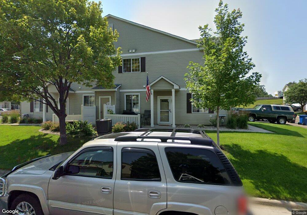
1832 Mockingbird Ave Unit 104 Shakopee, MN 55379
Estimated Value: $270,000 - $273,000
3
Beds
2
Baths
1,562
Sq Ft
$174/Sq Ft
Est. Value
About This Home
This home is located at 1832 Mockingbird Ave Unit 104, Shakopee, MN 55379 and is currently estimated at $271,266, approximately $173 per square foot. 1832 Mockingbird Ave Unit 104 is a home located in Scott County with nearby schools including Sun Path Elementary School, Shakopee West Middle School, and Shakopee Senior High School.
Ownership History
Date
Name
Owned For
Owner Type
Purchase Details
Closed on
Dec 3, 2021
Sold by
Hyatt David H and Hyatt Dinah Lee
Bought by
Luhman Joseph D
Current Estimated Value
Home Financials for this Owner
Home Financials are based on the most recent Mortgage that was taken out on this home.
Original Mortgage
$228,690
Outstanding Balance
$210,363
Interest Rate
3.12%
Mortgage Type
New Conventional
Estimated Equity
$60,903
Purchase Details
Closed on
Feb 25, 2000
Sold by
Centex Homes Minnesota Division
Bought by
Hyatt David H and Hyatt Dinah Lee
Create a Home Valuation Report for This Property
The Home Valuation Report is an in-depth analysis detailing your home's value as well as a comparison with similar homes in the area
Home Values in the Area
Average Home Value in this Area
Purchase History
| Date | Buyer | Sale Price | Title Company |
|---|---|---|---|
| Luhman Joseph D | $254,100 | Ocs Title | |
| Hyatt David H | $137,495 | -- |
Source: Public Records
Mortgage History
| Date | Status | Borrower | Loan Amount |
|---|---|---|---|
| Open | Luhman Joseph D | $228,690 |
Source: Public Records
Tax History Compared to Growth
Tax History
| Year | Tax Paid | Tax Assessment Tax Assessment Total Assessment is a certain percentage of the fair market value that is determined by local assessors to be the total taxable value of land and additions on the property. | Land | Improvement |
|---|---|---|---|---|
| 2025 | $2,338 | $252,600 | $76,100 | $176,500 |
| 2024 | $2,418 | $241,000 | $72,400 | $168,600 |
| 2023 | $2,476 | $237,400 | $71,000 | $166,400 |
| 2022 | $2,488 | $239,100 | $72,700 | $166,400 |
| 2021 | $2,146 | $209,100 | $57,000 | $152,100 |
| 2020 | $2,312 | $200,300 | $47,300 | $153,000 |
| 2019 | $2,182 | $191,100 | $45,000 | $146,100 |
| 2018 | $1,870 | $0 | $0 | $0 |
| 2016 | $1,842 | $0 | $0 | $0 |
| 2014 | -- | $0 | $0 | $0 |
Source: Public Records
Map
Nearby Homes
- 1844 Mockingbird Ave Unit 1102
- 1820 Mockingbird Ave
- 2148 Mcgregor Ln
- 1552 Dublin Ct
- 2471 Tyrone Dr
- 2447 Tyrone Dr
- 2399 Tyrone Dr
- 2263 Tyrone Dr
- 2312 Vierling Dr E
- 1511 England Way
- 2388 Vierling Dr E
- 1590 Countryside Dr Unit 5108
- 1022 Providence Dr
- 2006 Tyrone Dr
- 2052 Wilhelm Ct
- 1624 Philipp Way
- Lewis Plan at Summerland Place - Landmark Collection
- 2795 Downing Ave
- Vanderbilt Plan at Summerland Place - Landmark Collection
- Sinclair Plan at Summerland Place - Landmark Collection
- 1832 Mockingbird Ave Unit 1104
- 1848 Mockingbird Ave
- 1836 Mockingbird Ave
- 1852 Mockingbird Ave Unit 1106
- 1840 Mockingbird Ave
- 1856 Mockingbird Ave
- 1860 Mockingbird Ave
- 1816 Mockingbird Ave
- 1820 1820 Mockingbird Ave
- 1819 Mockingbird Ave
- 1861 Mockingbird Ave
- 1861 Mockingbird Ave Unit 1408
- 1815 Mockingbird Ave Unit 1306
- 1824 Mockingbird Ave
- 1824 1824 Mockingbird Ave
- 1865 Mockingbird Ave
- 1802 Mockingbird Ave
- 1804 Mockingbird Ave Unit 1203
- 1822 Pintail Ave Unit 1304
- 1811 Mockingbird Ave Unit 307