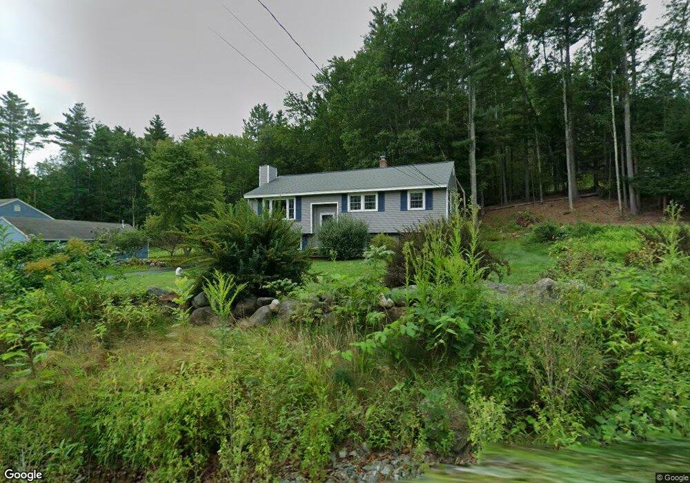
184 Burns Hill Rd Wilton, NH 03086
Estimated Value: $380,000 - $412,000
3
Beds
2
Baths
1,044
Sq Ft
$381/Sq Ft
Est. Value
About This Home
This home is located at 184 Burns Hill Rd, Wilton, NH 03086 and is currently estimated at $398,055, approximately $381 per square foot. 184 Burns Hill Rd is a home located in Hillsborough County with nearby schools including Florence Rideout Elementary School, Wilton-Lyndeborough Cooperative Middle School, and Wilton-Lyndeborough Cooperative High School.
Ownership History
Date
Name
Owned For
Owner Type
Purchase Details
Closed on
Aug 31, 1998
Sold by
Mcgovern Edward F
Bought by
Wells Douglas G
Current Estimated Value
Home Financials for this Owner
Home Financials are based on the most recent Mortgage that was taken out on this home.
Original Mortgage
$87,000
Outstanding Balance
$18,584
Interest Rate
6.9%
Estimated Equity
$379,471
Create a Home Valuation Report for This Property
The Home Valuation Report is an in-depth analysis detailing your home's value as well as a comparison with similar homes in the area
Home Values in the Area
Average Home Value in this Area
Purchase History
| Date | Buyer | Sale Price | Title Company |
|---|---|---|---|
| Wells Douglas G | $120,000 | -- |
Source: Public Records
Mortgage History
| Date | Status | Borrower | Loan Amount |
|---|---|---|---|
| Open | Wells Douglas G | $17,500 | |
| Open | Wells Douglas G | $87,000 |
Source: Public Records
Tax History Compared to Growth
Tax History
| Year | Tax Paid | Tax Assessment Tax Assessment Total Assessment is a certain percentage of the fair market value that is determined by local assessors to be the total taxable value of land and additions on the property. | Land | Improvement |
|---|---|---|---|---|
| 2024 | $6,339 | $254,900 | $107,300 | $147,600 |
| 2023 | $5,659 | $254,900 | $107,300 | $147,600 |
| 2022 | $5,266 | $254,900 | $107,300 | $147,600 |
| 2021 | $4,899 | $254,900 | $107,300 | $147,600 |
| 2020 | $5,411 | $184,100 | $79,200 | $104,900 |
| 2019 | $5,346 | $184,100 | $79,200 | $104,900 |
| 2018 | $5,295 | $184,100 | $79,200 | $104,900 |
| 2017 | $5,002 | $184,100 | $79,200 | $104,900 |
| 2016 | $4,823 | $183,100 | $79,200 | $103,900 |
| 2015 | $4,649 | $176,500 | $83,600 | $92,900 |
| 2014 | $4,554 | $176,500 | $83,600 | $92,900 |
| 2013 | $4,593 | $176,500 | $83,600 | $92,900 |
Source: Public Records
Map
Nearby Homes
- F/88-5 McGettigan Rd
- F/88-4 McGettigan Rd
- 81 Abbot Hill Acres
- 27 Island St
- 10 Mill St
- 8 Maple St
- 18 Richfield Way
- 88 McGettigan Rd Unit 88-6-1
- Lots 4 & 7 Gibbons & Robbins Rd
- 134 Falcon Ridge Rd Unit 23
- F-88-10 Aria Hill Dr
- F-88-11 Aria Hill Dr
- F-88-12 Aria Hill Dr
- F-88-7 Aria Hill Dr
- Lot F-88-9 Aria Hill Dr
- 0 Marden Rd
- 59 Goldsmith Rd
- 60 Goldsmith Rd
- A 66 Burton Hwy
- 24 Glass Factory Rd
- 178 Burns Hill Rd
- 193 Burns Hill Rd
- 181 Burns Hill Rd
- 39 Holt Rd
- 200 Burns Hill Rd
- 9 Holt Rd
- 173 Burns Hill Rd
- 168 Burns Hill Rd
- 167 Burns Hill Rd
- 205 Burns Hill Rd
- 164 Burns Hill Rd
- 139 Burns Hill Rd
- 160 Burns Hill Rd
- 25 Holt Rd
- 24 Holt Rd
- 100 Burns Hill Rd
- 156 Burns Hill Rd
- 31 Holt Rd
- 29 Holt Rd
- 150 Burns Hill Rd