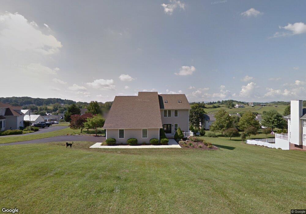
18430 Whites Point Dr Abingdon, TN 24211
Estimated Value: $490,000 - $613,000
4
Beds
4
Baths
4,302
Sq Ft
$127/Sq Ft
Est. Value
About This Home
This home is located at 18430 Whites Point Dr, Abingdon, TN 24211 and is currently estimated at $547,067, approximately $127 per square foot. 18430 Whites Point Dr is a home located in Washington County with nearby schools including Watauga Elementary School, E.B. Stanley Middle School, and Abingdon High School.
Ownership History
Date
Name
Owned For
Owner Type
Purchase Details
Closed on
Jun 17, 2022
Sold by
Maddox Kristoffer S and Maddox Leslie E
Bought by
Stevenson Robert Andrew and Stevenson Brennan Raye
Current Estimated Value
Home Financials for this Owner
Home Financials are based on the most recent Mortgage that was taken out on this home.
Original Mortgage
$465,000
Outstanding Balance
$442,449
Interest Rate
5.27%
Mortgage Type
VA
Estimated Equity
$104,618
Purchase Details
Closed on
Jun 17, 2020
Sold by
Ferris Damian M and Ferris Kathryn E
Bought by
Maddox Kristoffer S and Maddox Leslie E
Home Financials for this Owner
Home Financials are based on the most recent Mortgage that was taken out on this home.
Original Mortgage
$356,155
Interest Rate
3.2%
Mortgage Type
New Conventional
Purchase Details
Closed on
Nov 1, 2018
Sold by
Loomis Dianne W and Ferris Damian M
Bought by
Ferris Damian M and Ferris Kathryn E
Create a Home Valuation Report for This Property
The Home Valuation Report is an in-depth analysis detailing your home's value as well as a comparison with similar homes in the area
Home Values in the Area
Average Home Value in this Area
Purchase History
| Date | Buyer | Sale Price | Title Company |
|---|---|---|---|
| Stevenson Robert Andrew | $465,000 | New Title Company Name | |
| Maddox Kristoffer S | $374,900 | Attorney | |
| Ferris Damian M | -- | None Available |
Source: Public Records
Mortgage History
| Date | Status | Borrower | Loan Amount |
|---|---|---|---|
| Open | Stevenson Robert Andrew | $465,000 | |
| Previous Owner | Maddox Kristoffer S | $356,155 |
Source: Public Records
Tax History Compared to Growth
Tax History
| Year | Tax Paid | Tax Assessment Tax Assessment Total Assessment is a certain percentage of the fair market value that is determined by local assessors to be the total taxable value of land and additions on the property. | Land | Improvement |
|---|---|---|---|---|
| 2025 | $2,128 | $492,000 | $40,000 | $452,000 |
| 2024 | $2,128 | $354,700 | $40,000 | $314,700 |
| 2023 | $1,895 | $315,800 | $40,000 | $275,800 |
| 2022 | $1,895 | $315,800 | $40,000 | $275,800 |
| 2021 | $1,895 | $315,800 | $40,000 | $275,800 |
| 2019 | $1,908 | $302,900 | $40,000 | $262,900 |
| 2018 | $1,908 | $302,900 | $40,000 | $262,900 |
| 2017 | $1,908 | $302,900 | $40,000 | $262,900 |
| 2016 | $1,927 | $305,900 | $40,000 | $265,900 |
| 2015 | $1,927 | $305,900 | $40,000 | $265,900 |
| 2014 | $1,927 | $305,900 | $40,000 | $265,900 |
Source: Public Records
Map
Nearby Homes
- 18430 Whites Point Dr
- 21344 Jessica Ln
- 20385 Yeary Trail
- 21255 Vances Mill Rd
- 20536 Westchester Cir
- 19184 Spoon Gap Rd
- tbd Lot 89 E Cheyenne Trail
- LOT 89 Cheyenne Trail
- 20095 Hortenstine Place
- 20256 Avondale Rd
- 18343 Westwood Dr
- lOT121 Meadowbrook Dr
- 19025 Essex Dr
- 20033 Oakwood Dr
- 20017 Mccray Dr
- 19134 Amelia Dr
- 19494 Oakwood Dr
- 262 Hallock Dr
- 240 Hallock Dr
- 226 Hallock Dr
- 18414 Whites Point Dr
- 18436 Whites Point Dr
- 21092 Vances Mill Rd
- 21080 Vances Mill Rd
- 18439 Whites Point Dr
- 21108 Vances Mill Rd
- 18400 Whites Point Dr
- 18431 Whites Point Dr
- 21066 Vances Mill Rd
- 18415 Whites Point Dr
- 21122 Vances Mill Rd
- 18380 Whites Point Dr
- 21087 Vance's Mill Rd
- 21087 Vances Mill Rd
- 21073 Vance Mill Rd
- 21099 Vances Mill Rd
- 21073 Vances Mill Rd
- 18360 White's Point Dr
- 18387 Whites Point Dr
- 18360 Whites Point Dr