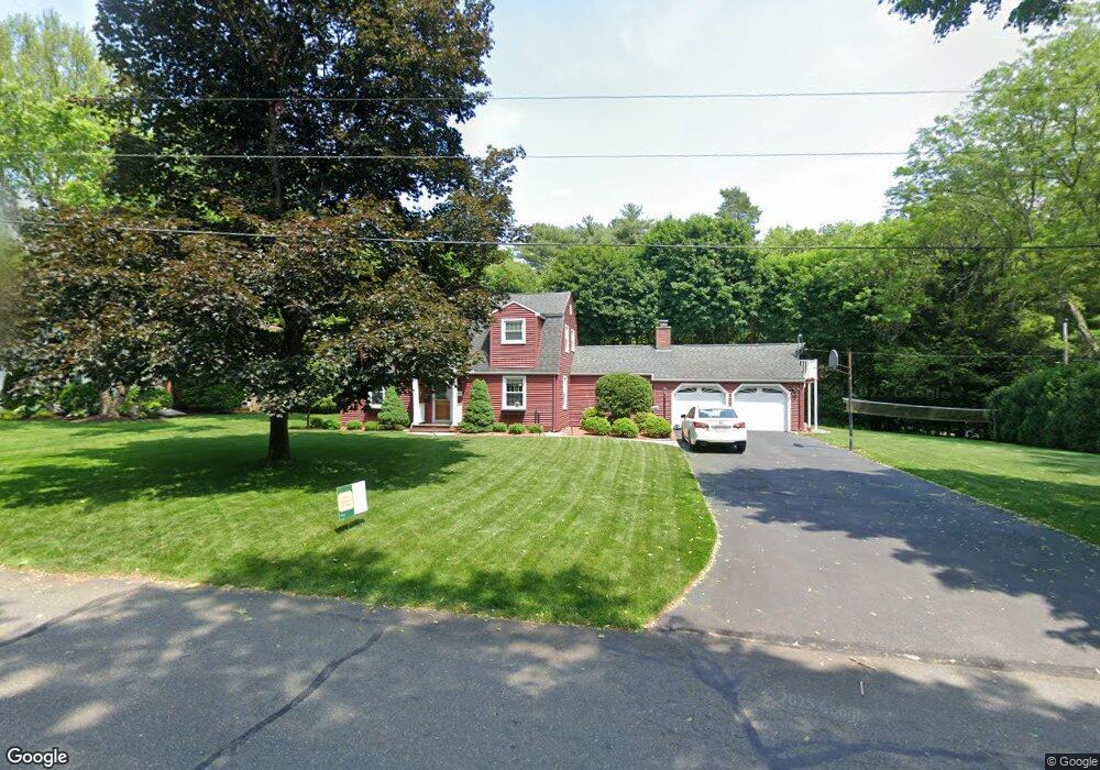
185 Viscount Rd Longmeadow, MA 01106
Estimated Value: $522,000 - $548,000
3
Beds
2
Baths
1,700
Sq Ft
$318/Sq Ft
Est. Value
About This Home
This home is located at 185 Viscount Rd, Longmeadow, MA 01106 and is currently estimated at $539,812, approximately $317 per square foot. 185 Viscount Rd is a home located in Hampden County with nearby schools including Blueberry Hill, Glenbrook Middle School, and Longmeadow High School.
Ownership History
Date
Name
Owned For
Owner Type
Purchase Details
Closed on
Dec 22, 2004
Sold by
Mattson Lynn E and Tomasetti Lynn E
Bought by
Quinlan John A and Quinlan Suzanne J
Current Estimated Value
Purchase Details
Closed on
Jul 29, 1988
Sold by
Cort Royce A
Bought by
Mattson Lynn E
Create a Home Valuation Report for This Property
The Home Valuation Report is an in-depth analysis detailing your home's value as well as a comparison with similar homes in the area
Home Values in the Area
Average Home Value in this Area
Purchase History
| Date | Buyer | Sale Price | Title Company |
|---|---|---|---|
| Quinlan John A | $315,000 | -- | |
| Mattson Lynn E | $226,000 | -- |
Source: Public Records
Mortgage History
| Date | Status | Borrower | Loan Amount |
|---|---|---|---|
| Open | Mattson Lynn E | $175,500 | |
| Closed | Mattson Lynn E | $99,716 |
Source: Public Records
Tax History Compared to Growth
Tax History
| Year | Tax Paid | Tax Assessment Tax Assessment Total Assessment is a certain percentage of the fair market value that is determined by local assessors to be the total taxable value of land and additions on the property. | Land | Improvement |
|---|---|---|---|---|
| 2025 | $10,030 | $474,900 | $173,400 | $301,500 |
| 2024 | $9,821 | $474,900 | $173,400 | $301,500 |
| 2023 | $9,581 | $418,000 | $157,700 | $260,300 |
| 2022 | $9,311 | $377,900 | $157,700 | $220,200 |
| 2021 | $8,963 | $362,300 | $150,200 | $212,100 |
| 2020 | $8,674 | $358,300 | $150,200 | $208,100 |
| 2019 | $8,407 | $349,000 | $150,200 | $198,800 |
| 2018 | $7,786 | $319,900 | $175,600 | $144,300 |
| 2017 | $7,543 | $319,900 | $175,600 | $144,300 |
| 2016 | $7,299 | $300,000 | $164,000 | $136,000 |
| 2015 | $7,095 | $300,400 | $162,400 | $138,000 |
Source: Public Records
Map
Nearby Homes
- 111 Ashford Rd
- 64 Magnolia Cir
- 361 Frank Smith Rd
- 217 Inverness Ln
- 911 Williams St
- 120 Inverness Ln
- 47 Academy Dr
- 196 Cambridge Cir
- 85 Inverness Ln
- 49 Wimbleton Dr
- 124 Tecumseh Dr
- 202 Williamsburg Dr
- 757 Shaker Rd
- 132 Coventry Ln
- 58 Shady Side Dr
- 67 Shady Side Dr
- 0 Dennis Rd
- 136 Fenwood Rd
- 52 Smithfield Ct
- 49 Fields Dr Unit 49
- 179 Viscount Rd
- 112 Captain Rd
- 186 Viscount Rd
- 165 Viscount Rd
- 172 Viscount Rd
- 136 Captain Rd
- 73 Captain Rd
- 99 Captain Rd
- 164 Viscount Rd
- 150 Captain Rd
- 153 Viscount Rd
- 52 Captain Rd
- 160 Captain Rd
- 111 Captain Rd
- 49 Captain Rd
- 37 E Primrose Dr
- 121 Captain Rd
- 135 Captain Rd
- 172 Captain Rd
- 143 Viscount Rd