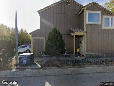
1851 Merchant St Sparks, NV 89431
Downtown Sparks NeighborhoodEstimated Value: $332,712 - $403,000
4
Beds
3
Baths
1,338
Sq Ft
$275/Sq Ft
Est. Value
About This Home
This home is located at 1851 Merchant St, Sparks, NV 89431 and is currently estimated at $367,428, approximately $274 per square foot. 1851 Merchant St is a home located in Washoe County with nearby schools including Robert Mitchell Elementary School, Sparks Middle School, and Sparks High School.
Ownership History
Date
Name
Owned For
Owner Type
Purchase Details
Closed on
Oct 11, 2007
Sold by
Rodriguez Tovar Antonio
Bought by
Rodriguez Tovar Antonio and Rodriguez Veronica
Current Estimated Value
Home Financials for this Owner
Home Financials are based on the most recent Mortgage that was taken out on this home.
Original Mortgage
$205,000
Interest Rate
6.4%
Mortgage Type
Unknown
Purchase Details
Closed on
May 18, 2004
Sold by
Casillas Robert
Bought by
Thompson Carl E
Home Financials for this Owner
Home Financials are based on the most recent Mortgage that was taken out on this home.
Original Mortgage
$122,550
Interest Rate
5.61%
Mortgage Type
Unknown
Create a Home Valuation Report for This Property
The Home Valuation Report is an in-depth analysis detailing your home's value as well as a comparison with similar homes in the area
Home Values in the Area
Average Home Value in this Area
Purchase History
| Date | Buyer | Sale Price | Title Company |
|---|---|---|---|
| Rodriguez Tovar Antonio | -- | Western Title Incorporated | |
| Rodriguez Tovar Antonio | -- | Western Title Incorporated | |
| Rodriguez Tovar Antonio | $205,000 | Western Title Incorporated | |
| Thompson Carl E | $129,000 | Founders Title Company Of Nv |
Source: Public Records
Mortgage History
| Date | Status | Borrower | Loan Amount |
|---|---|---|---|
| Open | Rodriguez Tovar Antonio | $167,000 | |
| Closed | Rodriguez Tovar Antonio | $197,600 | |
| Closed | Rodriguez Tovar Antonio | $205,000 | |
| Previous Owner | Thompson Carl E | $122,550 |
Source: Public Records
Tax History Compared to Growth
Tax History
| Year | Tax Paid | Tax Assessment Tax Assessment Total Assessment is a certain percentage of the fair market value that is determined by local assessors to be the total taxable value of land and additions on the property. | Land | Improvement |
|---|---|---|---|---|
| 2025 | $897 | $54,663 | $28,140 | $26,523 |
| 2024 | $833 | $50,066 | $25,620 | $24,446 |
| 2023 | $833 | $46,165 | $24,080 | $22,085 |
| 2022 | $772 | $39,751 | $20,265 | $19,486 |
| 2021 | $716 | $34,908 | $14,980 | $19,928 |
| 2020 | $678 | $36,046 | $15,610 | $20,436 |
| 2019 | $646 | $33,850 | $13,895 | $19,955 |
| 2018 | $611 | $30,361 | $10,500 | $19,861 |
| 2017 | $589 | $28,723 | $8,873 | $19,850 |
| 2016 | $622 | $27,854 | $7,403 | $20,451 |
| 2015 | $620 | $26,553 | $6,020 | $20,533 |
| 2014 | $602 | $25,482 | $4,830 | $20,652 |
| 2013 | -- | $14,504 | $2,380 | $12,124 |
Source: Public Records
Map
Nearby Homes
- 265 Mellen Ave
- 1023 Adrian Way
- 1001 Adrian Way
- 995 Adrian Way
- 1616 Greenbrae Dr
- 1645 Meadowvale Way
- 2168 Cannonball Rd
- 963 Flatcar Ln
- 2085 G St
- 2107 G St
- 1365 Prospect Ave
- 2165 Capurro Way
- 1700 Byrd Dr
- 2101 Roundhouse Rd
- 1150 El Rancho Dr
- 2369 Roundhouse Rd
- 1213 H St
- 1010 12th St
- 2380 Roundhouse Rd
- 1702 London Cir
- 1851 Merchant St
- 1855 Merchant St
- 1849 Merchant St
- 1865 Merchant St
- 1845 Merchant St
- 1859 Merchant St
- 1863 Merchant St
- 1867 Merchant St
- 1861 Merchant St
- 1830 Brunetti Way
- 1841 Merchant St
- 1838 Brunetti Way
- 1871 Merchant St
- 1828 Brunetti Way
- 1840 Brunetti Way
- 1837 Merchant St
- 1833 Merchant St
- 1875 Merchant St
- 1829 Merchant St
- 1825 Merchant St