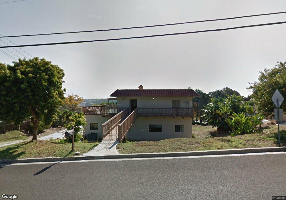
1855 Laurel Rd Oceanside, CA 92054
Fire Mountain NeighborhoodEstimated Value: $1,288,912 - $1,480,000
3
Beds
2
Baths
2,056
Sq Ft
$690/Sq Ft
Est. Value
About This Home
This home is located at 1855 Laurel Rd, Oceanside, CA 92054 and is currently estimated at $1,419,478, approximately $690 per square foot. 1855 Laurel Rd is a home located in San Diego County with nearby schools including Palmquist Elementary School, Lincoln Middle School, and Oceanside High School.
Ownership History
Date
Name
Owned For
Owner Type
Purchase Details
Closed on
Jul 28, 2003
Sold by
Marchal E Frederick and Marchal Shannon
Bought by
Northrup Jason and Northrup Angela
Current Estimated Value
Home Financials for this Owner
Home Financials are based on the most recent Mortgage that was taken out on this home.
Original Mortgage
$396,000
Outstanding Balance
$168,658
Interest Rate
5.17%
Mortgage Type
Unknown
Estimated Equity
$1,250,820
Purchase Details
Closed on
Dec 1, 2002
Sold by
Probst Janet M
Bought by
Marchal E Frederick and Marchal Shannon
Purchase Details
Closed on
Dec 16, 1993
Sold by
Probst Janet M and Probst Deborah J
Bought by
Probst Janet M
Purchase Details
Closed on
Nov 15, 1993
Sold by
Probst Janet M
Bought by
Probst Janet M and Probst Deborah J
Create a Home Valuation Report for This Property
The Home Valuation Report is an in-depth analysis detailing your home's value as well as a comparison with similar homes in the area
Home Values in the Area
Average Home Value in this Area
Purchase History
| Date | Buyer | Sale Price | Title Company |
|---|---|---|---|
| Northrup Jason | $495,000 | New Century Title Company | |
| Marchal E Frederick | $365,000 | New Century Title Company | |
| Probst Janet M | -- | Stewart Title Company | |
| Probst Janet M | -- | -- |
Source: Public Records
Mortgage History
| Date | Status | Borrower | Loan Amount |
|---|---|---|---|
| Open | Northrup Jason | $396,000 |
Source: Public Records
Tax History
| Year | Tax Paid | Tax Assessment Tax Assessment Total Assessment is a certain percentage of the fair market value that is determined by local assessors to be the total taxable value of land and additions on the property. | Land | Improvement |
|---|---|---|---|---|
| 2025 | $7,687 | $703,752 | $454,952 | $248,800 |
| 2024 | $7,687 | $689,954 | $446,032 | $243,922 |
| 2023 | $7,449 | $676,427 | $437,287 | $239,140 |
| 2022 | $7,335 | $663,164 | $428,713 | $234,451 |
| 2021 | $7,363 | $650,161 | $420,307 | $229,854 |
| 2020 | $7,134 | $643,496 | $415,998 | $227,498 |
| 2019 | $6,926 | $630,880 | $407,842 | $223,038 |
| 2018 | $6,851 | $618,511 | $399,846 | $218,665 |
| 2017 | $70 | $606,384 | $392,006 | $214,378 |
| 2016 | $6,290 | $575,000 | $370,000 | $205,000 |
| 2015 | $6,026 | $559,000 | $360,000 | $199,000 |
| 2014 | $5,908 | $559,000 | $360,000 | $199,000 |
Source: Public Records
Map
Nearby Homes
- 1989 Seawind Way
- 2619 Fire Mountain Dr
- 2301 Ivy Rd
- 1824 Portofino Dr
- 2245 Ivy Rd
- 1850 Downs St
- 2835 Valley Vista Way
- 1782 Troy Ln
- 1355 Knoll Dr
- 2241 California St
- 2311 Loker Way
- 1520 Downs St
- 2309 Loker Way
- 2312 Loker Way
- 2308 Loker Way
- 2306 Loker Way
- 1535 Molly Cir
- 1773 Ivy Rd
- 1765 Ivy Rd
- 1305 Cornish Dr
- 1839 Campesino Place
- 1859 Laurel Rd
- 1824 Campesino Place
- 1841 Campesino Place
- 1869 Laurel Rd
- 1872 Laurel Rd
- 1828 Campesino Place
- 1840 Laurel Rd
- 1843 Campesino Place
- 1887 Laurel Rd
- 1885 Laurel Rd
- 1832 Campesino Place
- 1866 Laurel Rd
- 1874 Laurel Rd
- 1860 Laurel Rd
- 1842 Laurel Rd
- 1838 Laurel Rd
- 1836 Campesino Place
- 145 Ryan Way
- 150 Ryan Way
Your Personal Tour Guide
Ask me questions while you tour the home.