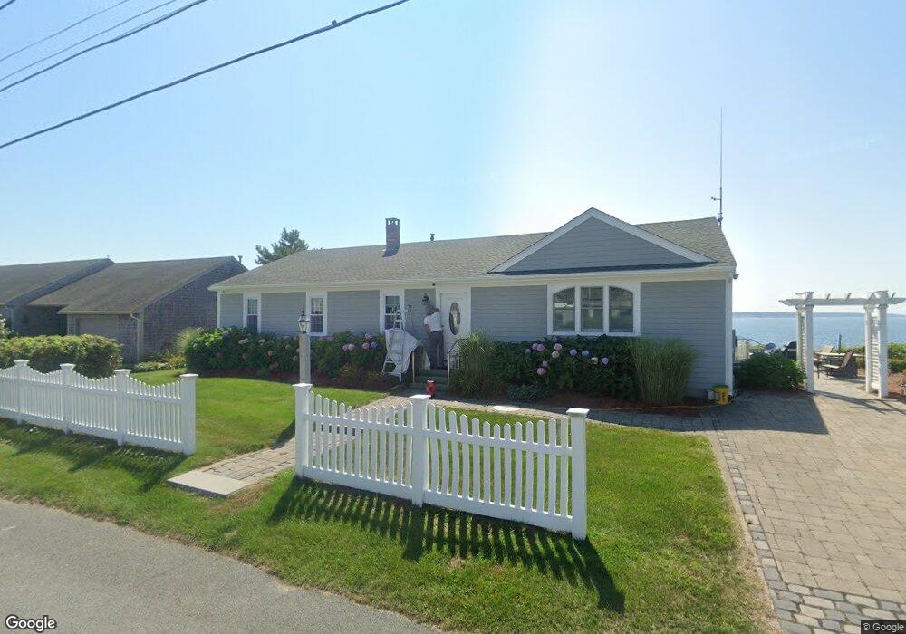
186 Captains Row Bourne, MA 2532
Estimated Value: $1,321,000 - $2,157,000
3
Beds
3
Baths
1,680
Sq Ft
$986/Sq Ft
Est. Value
About This Home
This home is located at 186 Captains Row, Bourne, MA 2532 and is currently estimated at $1,656,042, approximately $985 per square foot. 186 Captains Row is a home with nearby schools including Bourne High School.
Ownership History
Date
Name
Owned For
Owner Type
Purchase Details
Closed on
Apr 13, 2012
Sold by
Bronstein Peter H and Whittaker Sandra J
Bought by
Rudnicki
Current Estimated Value
Purchase Details
Closed on
Apr 23, 2008
Sold by
Bronstein Peter H
Bought by
Bronstein Peter H and Whittaker Sandra J
Purchase Details
Closed on
Mar 17, 2000
Sold by
Oreilly Paul D and Brenda Oreilly M
Bought by
Bronstein Peter H
Create a Home Valuation Report for This Property
The Home Valuation Report is an in-depth analysis detailing your home's value as well as a comparison with similar homes in the area
Purchase History
| Date | Buyer | Sale Price | Title Company |
|---|---|---|---|
| Rudnicki | $800,000 | -- | |
| Rudnicki | $800,000 | -- | |
| Bronstein Peter H | -- | -- | |
| Bronstein Peter H | -- | -- | |
| Bronstein Peter H | $450,000 | -- | |
| Bronstein Peter H | $450,000 | -- |
Source: Public Records
Mortgage History
| Date | Status | Borrower | Loan Amount |
|---|---|---|---|
| Previous Owner | Bronstein Peter H | $500,000 | |
| Previous Owner | Bronstein Peter H | $350,000 |
Source: Public Records
Tax History
| Year | Tax Paid | Tax Assessment Tax Assessment Total Assessment is a certain percentage of the fair market value that is determined by local assessors to be the total taxable value of land and additions on the property. | Land | Improvement |
|---|---|---|---|---|
| 2025 | $10,188 | $1,304,500 | $981,400 | $323,100 |
| 2024 | $9,962 | $1,242,200 | $934,600 | $307,600 |
| 2023 | $9,686 | $1,099,400 | $827,200 | $272,200 |
| 2022 | $9,593 | $950,700 | $732,000 | $218,700 |
| 2021 | $9,320 | $865,400 | $666,200 | $199,200 |
| 2020 | $9,132 | $850,300 | $659,800 | $190,500 |
| 2019 | $8,847 | $841,800 | $659,800 | $182,000 |
| 2018 | $2,166 | $793,100 | $628,500 | $164,600 |
| 2017 | $8,009 | $777,600 | $622,600 | $155,000 |
| 2016 | $7,997 | $787,100 | $657,200 | $129,900 |
| 2015 | $7,926 | $787,100 | $657,200 | $129,900 |
Source: Public Records
Map
Nearby Homes
- 248 Great Neck Rd
- 566 Shore Rd
- 14 Navajo Rd
- 35 Benedict Rd
- 200 Great Neck Rd
- 254 Barlows Landing Rd
- 203 County Rd
- 60 Bourne Neck Dr
- 709 County Rd
- 16 Michael Rd
- 36B Starboard Dr Unit 36E
- 36B Starboard Dr Unit 36G
- 36B Starboard Dr Unit 36C
- 36B Starboard Dr Unit 36A
- 36B Starboard Dr Unit 36D
- 36B Starboard Dr Unit 36B
- 36B Starboard Dr Unit 36F
- 36B Starboard Dr Unit 36H
- 23 Starboard Dr Unit Lot 50
- 3 Carleton St Unit 3
- 186 Captains Row
- 187 Captains Row
- 184 Captains Row
- 0 Leeward Rd Unit 71227280
- 153 Captains Row
- 153 Captains Row
- 185 Captains Row
- 188 Captains Row
- 182 Leeward Rd
- 188 Captains Row
- 149 Leeward Rd
- 149 Leeward Rd
- 183 Clipper Rd
- 84 Captains Row
- 189A Captains Row
- 189-B Captains Row
- 180 Leeward Rd
- 189-A Captains Row
- 180 Leeward Rd
- 181 Clipper Rd
Your Personal Tour Guide
Ask me questions while you tour the home.