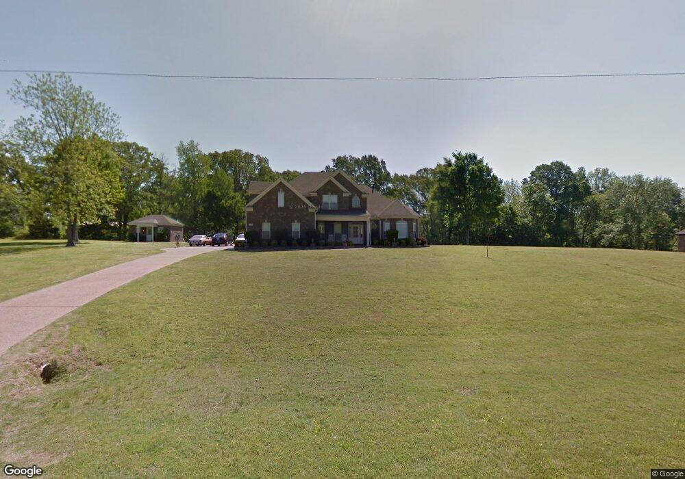
1866 Saulsberry Dr Nesbit, MS 38651
Pleasant Hill NeighborhoodEstimated Value: $384,000 - $429,000
4
Beds
--
Bath
3,057
Sq Ft
$132/Sq Ft
Est. Value
About This Home
This home is located at 1866 Saulsberry Dr, Nesbit, MS 38651 and is currently estimated at $404,626, approximately $132 per square foot. 1866 Saulsberry Dr is a home located in DeSoto County with nearby schools including DeSoto Central Primary School, DeSoto Central Elementary School, and DeSoto Central Middle School.
Ownership History
Date
Name
Owned For
Owner Type
Purchase Details
Closed on
Jun 27, 2017
Sold by
Preston E Hurlburt
Bought by
Harrison Nathaniel and Harrison Vairrelee
Current Estimated Value
Home Financials for this Owner
Home Financials are based on the most recent Mortgage that was taken out on this home.
Original Mortgage
$262,163
Outstanding Balance
$215,749
Interest Rate
3.9%
Estimated Equity
$188,877
Create a Home Valuation Report for This Property
The Home Valuation Report is an in-depth analysis detailing your home's value as well as a comparison with similar homes in the area
Home Values in the Area
Average Home Value in this Area
Purchase History
| Date | Buyer | Sale Price | Title Company |
|---|---|---|---|
| Harrison Nathaniel | -- | -- |
Source: Public Records
Mortgage History
| Date | Status | Borrower | Loan Amount |
|---|---|---|---|
| Open | Harrison Nathaniel | $262,163 | |
| Closed | Harrison Nathaniel | -- |
Source: Public Records
Tax History
| Year | Tax Paid | Tax Assessment Tax Assessment Total Assessment is a certain percentage of the fair market value that is determined by local assessors to be the total taxable value of land and additions on the property. | Land | Improvement |
|---|---|---|---|---|
| 2025 | $1,560 | $20,893 | $3,000 | $17,893 |
| 2024 | $1,858 | $20,893 | $3,000 | $17,893 |
| 2023 | $1,858 | $20,893 | $0 | $0 |
| 2022 | $1,858 | $20,893 | $3,000 | $17,893 |
| 2021 | $2,599 | $20,893 | $3,000 | $17,893 |
| 2020 | $2,398 | $19,445 | $3,000 | $16,445 |
| 2019 | $2,398 | $19,445 | $3,000 | $16,445 |
| 2017 | $2,476 | $36,814 | $19,907 | $16,907 |
| 2016 | $2,360 | $19,907 | $3,000 | $16,907 |
| 2015 | $2,660 | $36,814 | $19,907 | $16,907 |
| 2014 | $2,297 | $19,907 | $0 | $0 |
| 2013 | $2,362 | $19,907 | $0 | $0 |
Source: Public Records
Map
Nearby Homes
- 5252 Watson View Dr
- 5185 Watson View Dr
- 4789 Bakers Trail E
- 3390 Hatton Dr
- 0 Highway 51 Unit 2319030
- 555 Emma Cove
- 0 U S Highway 51
- 566 Benton Dr
- 1734 Winningham Dr
- 1802 Millers Cove
- 636 Tallahatchie St
- 654 Tallahatchie St
- 1547 Breckenridge Dr
- 970 Coahoma Ct
- 940 Coahoma Ct
- 928 Coahoma Ct
- 902 Coahoma Ct
- 2154 Laughter Rd N
- 939 Buttermilk Dr
- 896 Andys Way
- 1 Saulsberry Dr
- 5 Saulsberry Dr
- 7 Saulsberry Dr
- 4 Saulsberry Dr
- 6 Saulsberry Dr
- 2 Saulsberry Dr
- 1849 Saulsberry Creek Dr
- 8 Saulsberry Creek Dr
- 10 Saulsberry Creek Dr
- 1732 Saulsberry Dr
- 1900 Saulsberry Dr
- 1900 Saulsberry Creek Dr
- 1775 Saulsberry Creek Dr
- 810 Saulsberry Creek Dr
- 1875 Saulsberry Dr
- 1841 Saulsberry Dr
- 1929 Saulsberry Creek Dr
- 1793 Saulsberry Dr
- 1793 Saulsberry Dr
- 1780 Saulsberry Dr
Your Personal Tour Guide
Ask me questions while you tour the home.