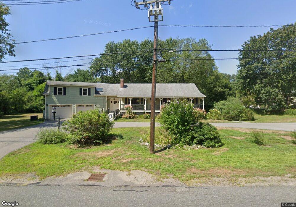
187 7 Star Rd Groveland, MA 01834
Estimated Value: $737,000 - $969,000
5
Beds
3
Baths
3,305
Sq Ft
$256/Sq Ft
Est. Value
About This Home
This home is located at 187 7 Star Rd, Groveland, MA 01834 and is currently estimated at $845,355, approximately $255 per square foot. 187 7 Star Rd is a home located in Essex County with nearby schools including Pentucket Regional High School.
Ownership History
Date
Name
Owned For
Owner Type
Purchase Details
Closed on
Feb 6, 2018
Sold by
Smithers Margaret K
Bought by
Jorgensen John J and Jorgensen Pamela M
Current Estimated Value
Home Financials for this Owner
Home Financials are based on the most recent Mortgage that was taken out on this home.
Original Mortgage
$444,190
Outstanding Balance
$375,715
Interest Rate
3.94%
Mortgage Type
FHA
Estimated Equity
$469,640
Create a Home Valuation Report for This Property
The Home Valuation Report is an in-depth analysis detailing your home's value as well as a comparison with similar homes in the area
Home Values in the Area
Average Home Value in this Area
Purchase History
| Date | Buyer | Sale Price | Title Company |
|---|---|---|---|
| Jorgensen John J | $430,000 | -- |
Source: Public Records
Mortgage History
| Date | Status | Borrower | Loan Amount |
|---|---|---|---|
| Open | Jorgensen John J | $444,190 |
Source: Public Records
Tax History Compared to Growth
Tax History
| Year | Tax Paid | Tax Assessment Tax Assessment Total Assessment is a certain percentage of the fair market value that is determined by local assessors to be the total taxable value of land and additions on the property. | Land | Improvement |
|---|---|---|---|---|
| 2025 | $9,573 | $754,400 | $252,600 | $501,800 |
| 2024 | $9,422 | $695,900 | $239,600 | $456,300 |
| 2023 | $8,570 | $652,700 | $217,800 | $434,900 |
| 2022 | $8,404 | $580,800 | $191,700 | $389,100 |
| 2021 | $7,560 | $513,600 | $174,200 | $339,400 |
| 2020 | $6,290 | $447,700 | $161,200 | $286,500 |
| 2019 | $6,429 | $448,000 | $161,200 | $286,800 |
| 2018 | $6,298 | $428,700 | $152,500 | $276,200 |
| 2017 | $6,083 | $414,400 | $152,500 | $261,900 |
| 2016 | $5,838 | $386,900 | $143,700 | $243,200 |
| 2015 | $5,504 | $376,700 | $135,000 | $241,700 |
| 2014 | $5,328 | $353,800 | $135,000 | $218,800 |
Source: Public Records
Map
Nearby Homes
- 123 Pond St
- Lot 9 Katie Ln
- Lot 8 Katie Ln
- 98 King St
- Lot 11A King St
- 231 W Main St
- 206 W Main St Unit 3
- 206 W Main St Unit 5
- 206 W Main St Unit 6
- 206 W Main St Unit 4
- 89 King St
- 0 Wood St
- 18 Larch Rd
- 5 Charles St
- 51 W Main St Unit 6
- 603 Alyssa Dr Unit 603
- 30 Forest St
- 34 E Main St Unit 2
- 21 Francis Ave
- 6 Winter St