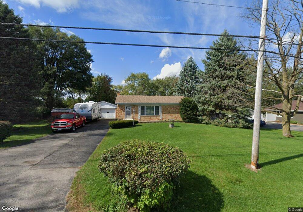
1870 Mitchell Rd Aurora, IL 60505
Indian Creek NeighborhoodEstimated Value: $242,000 - $312,000
3
Beds
1
Bath
912
Sq Ft
$307/Sq Ft
Est. Value
About This Home
This home is located at 1870 Mitchell Rd, Aurora, IL 60505 and is currently estimated at $279,753, approximately $306 per square foot. 1870 Mitchell Rd is a home located in Kane County with nearby schools including Schneider Elementary School, Herget Middle School, and West Aurora High School.
Ownership History
Date
Name
Owned For
Owner Type
Purchase Details
Closed on
Oct 31, 2002
Sold by
Franzen Carol
Bought by
Bramm Eric E and Bramm Nadine E
Current Estimated Value
Home Financials for this Owner
Home Financials are based on the most recent Mortgage that was taken out on this home.
Original Mortgage
$117,000
Outstanding Balance
$49,583
Interest Rate
6.18%
Estimated Equity
$230,170
Create a Home Valuation Report for This Property
The Home Valuation Report is an in-depth analysis detailing your home's value as well as a comparison with similar homes in the area
Home Values in the Area
Average Home Value in this Area
Purchase History
| Date | Buyer | Sale Price | Title Company |
|---|---|---|---|
| Bramm Eric E | $130,000 | Chicago Title Insurance Co |
Source: Public Records
Mortgage History
| Date | Status | Borrower | Loan Amount |
|---|---|---|---|
| Open | Bramm Eric E | $117,000 |
Source: Public Records
Tax History
| Year | Tax Paid | Tax Assessment Tax Assessment Total Assessment is a certain percentage of the fair market value that is determined by local assessors to be the total taxable value of land and additions on the property. | Land | Improvement |
|---|---|---|---|---|
| 2024 | $4,499 | $81,568 | $15,269 | $66,299 |
| 2023 | $4,298 | $72,881 | $13,643 | $59,238 |
| 2022 | $3,867 | $62,513 | $12,448 | $50,065 |
| 2021 | $3,683 | $58,200 | $11,589 | $46,611 |
| 2020 | $3,471 | $54,059 | $10,764 | $43,295 |
| 2019 | $3,349 | $50,087 | $9,973 | $40,114 |
| 2018 | $3,189 | $46,685 | $9,225 | $37,460 |
| 2017 | $3,378 | $47,831 | $7,381 | $40,450 |
| 2016 | $3,208 | $44,277 | $6,327 | $37,950 |
| 2015 | -- | $37,192 | $5,441 | $31,751 |
| 2014 | -- | $35,770 | $5,233 | $30,537 |
| 2013 | -- | $37,267 | $5,158 | $32,109 |
Source: Public Records
Map
Nearby Homes
- 471 Woodlyn Dr Unit 3
- 440 Woodlyn Dr
- 1923 Schomer Ct
- 1615 Margaret Ln
- 1220 Mitchell Rd
- 1750 N Marywood Ave Unit 513
- 1750 N Marywood Ave Unit 305
- 1750 N Marywood Ave Unit 216
- 1750 N Marywood Ave Unit 315
- 1235 Constellation Dr
- 1105 Assell Ave
- 1826 N Farnsworth Ave
- 1160 N Ohio St Unit 62
- 1050 N Farnsworth Ave Unit 111
- 1050 N Farnsworth Ave Unit 403
- 28 Oak Creek Ct
- 1009 Assell Ave
- 1992 Tall Oaks Dr Unit 2B
- 920 Zenner Ave
- 304 Hankes Ave
- 1880 Mitchell Rd
- 1850 Mitchell Rd
- 1861 Carolyn Dr
- 1845 Carolyn Dr
- 1881 Carolyn Dr
- 605 Schomer Rd
- 1840 Mitchell Rd
- 1910 Mitchell Rd
- 1831 Carolyn Dr
- 1911 Carolyn Dr
- 628 Schomer Rd
- 625 Schomer Rd
- 603 Friar Dr
- 1850 Carolyn Dr
- 1870 Carolyn Dr
- 1840 Carolyn Dr
- 617 Friar Dr
- 1820 Mitchell Rd Unit 1
- 642 Schomer Rd
- 1815 High St
Your Personal Tour Guide
Ask me questions while you tour the home.