Estimated Value: $5,654,000 - $9,140,450
4
Beds
5
Baths
3,693
Sq Ft
$2,145/Sq Ft
Est. Value
About This Home
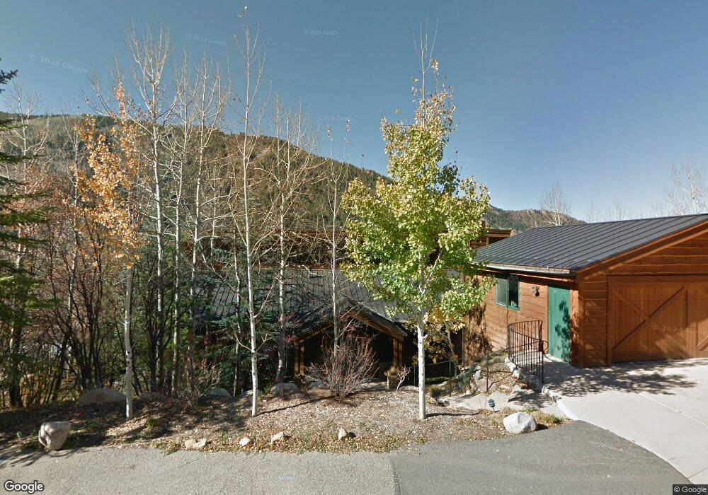
This home is located at 189 Mountain Laurel Dr, Aspen, CO 81611 and is currently estimated at $7,919,817, approximately $2,144 per square foot. 189 Mountain Laurel Dr is a home located in Pitkin County with nearby schools including Aspen Elementary School, Aspen Middle School, and Aspen High School.
Ownership History
Date
Name
Owned For
Owner Type
Purchase Details
Closed on
Dec 18, 2020
Sold by
Rubenstein Gail
Bought by
Rubenstein Ronald L and Rubenstein Gail A
Current Estimated Value
Purchase Details
Closed on
Oct 28, 2002
Sold by
Pitkin Exchange Holdings Of Aspen Llc
Bought by
Rubenstein Gail
Home Financials for this Owner
Home Financials are based on the most recent Mortgage that was taken out on this home.
Original Mortgage
$825,000
Interest Rate
6.33%
Mortgage Type
Seller Take Back
Purchase Details
Closed on
Sep 6, 2002
Sold by
Dow B Hickam Investments Lp
Bought by
Pitkin Exchange Holdings Of Aspen Llc
Home Financials for this Owner
Home Financials are based on the most recent Mortgage that was taken out on this home.
Original Mortgage
$825,000
Interest Rate
6.33%
Mortgage Type
Seller Take Back
Create a Home Valuation Report for This Property
The Home Valuation Report is an in-depth analysis detailing your home's value as well as a comparison with similar homes in the area
Home Values in the Area
Average Home Value in this Area
Purchase History
| Date | Buyer | Sale Price | Title Company |
|---|---|---|---|
| Rubenstein Ronald L | $3,375,000 | Pitkin County Title | |
| Rubenstein Gail | $2,400,000 | -- | |
| Pitkin Exchange Holdings Of Aspen Llc | $2,400,000 | -- |
Source: Public Records
Mortgage History
| Date | Status | Borrower | Loan Amount |
|---|---|---|---|
| Previous Owner | Pitkin Exchange Holdings Of Aspen Llc | $825,000 | |
| Closed | Pitkin Exchange Holdings Of Aspen Llc | $1,600,000 |
Source: Public Records
Tax History
| Year | Tax Paid | Tax Assessment Tax Assessment Total Assessment is a certain percentage of the fair market value that is determined by local assessors to be the total taxable value of land and additions on the property. | Land | Improvement |
|---|---|---|---|---|
| 2025 | $16,263 | $493,520 | $265,630 | $227,890 |
| 2024 | $16,263 | $684,050 | $239,910 | $444,140 |
| 2023 | $19,866 | $693,380 | $243,180 | $450,200 |
| 2022 | $10,437 | $325,930 | $166,800 | $159,130 |
| 2021 | $10,410 | $335,310 | $171,600 | $163,710 |
| 2020 | $9,022 | $289,730 | $157,300 | $132,430 |
| 2019 | $9,022 | $289,730 | $157,300 | $132,430 |
| 2018 | $8,747 | $291,750 | $158,400 | $133,350 |
| 2017 | $7,605 | $280,630 | $136,800 | $143,830 |
| 2016 | $6,361 | $230,160 | $119,400 | $110,760 |
| 2015 | $6,322 | $230,160 | $119,400 | $110,760 |
| 2014 | $6,744 | $239,710 | $139,300 | $100,410 |
Source: Public Records
Map
Nearby Homes
- 257 Mountain Laurel Dr
- 250 Mountain Laurel Dr Unit B
- 184 Mountain Laurel Dr
- 190 W Lupine Dr
- 40 Mountain Laurel Ln
- 602 Mountain Laurel Dr
- 82 Northway Dr
- 552 Mountain Laurel Dr
- 663 Mountain Laurel Dr
- 161 Stillwater Ln
- 31 Northstar Cir
- 43001 Colorado 82
- 1345 Mayflower Ct
- 96 McSkimming Rd
- 100 Park Ave
- 1195 E Cooper Ave Unit A
- 71 & 73 Smuggler Grove Rd
- 63 Smuggler Grove
- 1212 E Hopkins Ave
- 326 Midland Ave Unit 302
- 45 E Lupine Dr
- 201 Mountain Laurel Dr
- 153 Mountain Laurel Dr
- 19 E Lupine Dr
- 91 E Lupine Dr
- 198 Mountain Laurel Dr
- 176 Mountain Laurel Dr
- 103 E Lupine Dr Unit 103
- 123 Mountain Laurel Dr
- 39 W Lupine Dr
- 0234 Mountain Laurel Dr
- 234 Mountain Laurel Dr
- 178 Mountain Laurel Dr
- 42555 Highway 82 Unit B
- 42575 Highway 82
- 105 E Lupine Dr Unit 105
- 42591 Highway 82 Unit B
- 42591 Highway 82 Unit A
- 42591 Highway 82
- 42553 Colorado 82
Your Personal Tour Guide
Ask me questions while you tour the home.