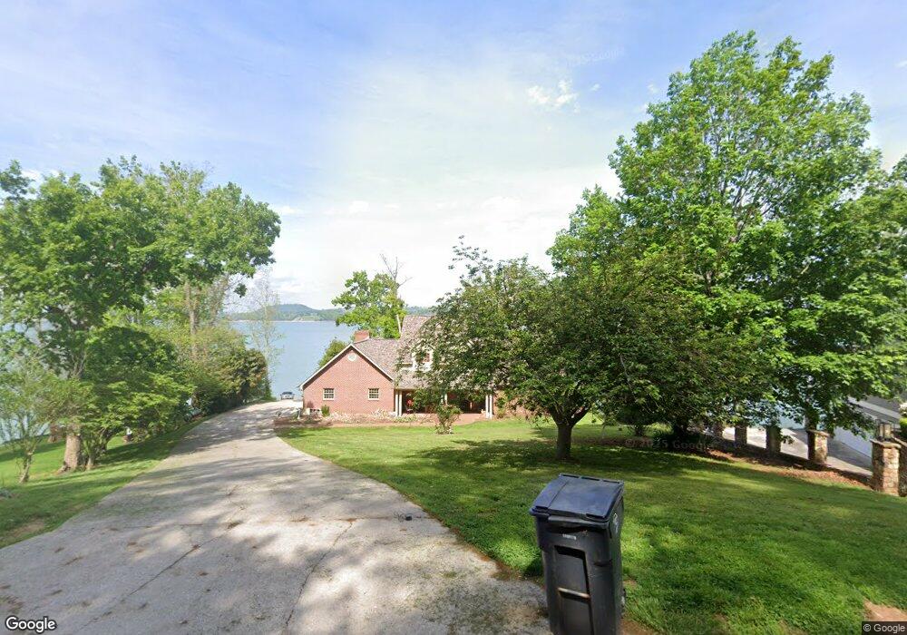
1899 Pointe Dr Talbott, TN 37877
Estimated Value: $903,000 - $1,191,000
Studio
4
Baths
4,035
Sq Ft
$255/Sq Ft
Est. Value
About This Home
This home is located at 1899 Pointe Dr, Talbott, TN 37877 and is currently estimated at $1,030,077, approximately $255 per square foot. 1899 Pointe Dr is a home located in Hamblen County with nearby schools including Alpha Elementary School, West View Middle School, and Morristown West High School.
Ownership History
Date
Name
Owned For
Owner Type
Purchase Details
Closed on
Jun 11, 1990
Bought by
Stinson Warren K
Current Estimated Value
Purchase Details
Closed on
Mar 20, 1990
Bought by
Bunch Don Agricultural Rights Only
Purchase Details
Closed on
Nov 15, 1989
Bought by
Bunch Don
Purchase Details
Closed on
Sep 11, 1976
Bought by
Repass Earl H and Repass Hazel
Create a Home Valuation Report for This Property
The Home Valuation Report is an in-depth analysis detailing your home's value as well as a comparison with similar homes in the area
Purchase History
| Date | Buyer | Sale Price | Title Company |
|---|---|---|---|
| Stinson Warren K | $60,000 | -- | |
| Bunch Don Agricultural Rights Only | $100 | -- | |
| Bunch Don | $275,000 | -- | |
| Repass Earl H | -- | -- |
Source: Public Records
Tax History
| Year | Tax Paid | Tax Assessment Tax Assessment Total Assessment is a certain percentage of the fair market value that is determined by local assessors to be the total taxable value of land and additions on the property. | Land | Improvement |
|---|---|---|---|---|
| 2025 | $3,513 | $238,975 | $36,875 | $202,100 |
| 2024 | $2,836 | $143,950 | $39,950 | $104,000 |
| 2023 | $2,836 | $143,950 | $0 | $0 |
| 2022 | $2,836 | $143,950 | $39,950 | $104,000 |
| 2021 | $2,836 | $143,950 | $39,950 | $104,000 |
| 2020 | $2,836 | $143,950 | $39,950 | $104,000 |
| 2019 | $2,382 | $111,825 | $39,650 | $72,175 |
| 2018 | $2,382 | $111,825 | $39,650 | $72,175 |
| 2017 | $2,382 | $111,825 | $39,650 | $72,175 |
| 2016 | $2,225 | $111,825 | $39,650 | $72,175 |
| 2015 | $2,069 | $111,825 | $39,650 | $72,175 |
| 2014 | -- | $111,825 | $39,650 | $72,175 |
| 2013 | -- | $117,875 | $0 | $0 |
Source: Public Records
Map
Nearby Homes
- 7713 Melanie Cir
- tbd Lebanon Church Rd
- 2107 Windy Cove Ln
- 7346 Circle Point Dr
- 1437 Beacon Rd
- 8070 W Pointe Dr
- Lot 135 W Point Dr
- 634 Heather Brook Cir
- 254 Alberts Cove
- 211 Sequoyah Trail
- 487 Heather Brook Dr
- 1256 Pratt Rd
- 7474 Evolene Cir
- 1167 Cherry Blossom Ln
- 1533 Allen Rd
- Lot 3 Lowe Dr
- Lot 1R1 Lowe Dr
- 595 Ricky Dr
- 2559 Dogwood Ln
- 1050 Briar Ct
- 1889 Pointe Dr
- 1917 Pointe Dr
- 1881 Pointe Dr
- 1929 Pointe Dr
- 1865 Pointe Dr
- 1937 Pointe Dr
- 1851 Pointe Dr
- 1880 Pointe Dr
- 1945 Pointe Dr
- 1831 Pointe Dr
- 1953 Wilderness Dr
- 1949 Wilderness Dr
- 1624 Fledgling Ln
- 1798 Pointe Dr
- 1937 Wilderness Dr
- 1850 Honeysuckle Ln
- 1911 Wilderness Dr
- 1960 Wilderness Dr
- 1887 Wilderness Dr
- 1815 Pointe Dr
Your Personal Tour Guide
Ask me questions while you tour the home.