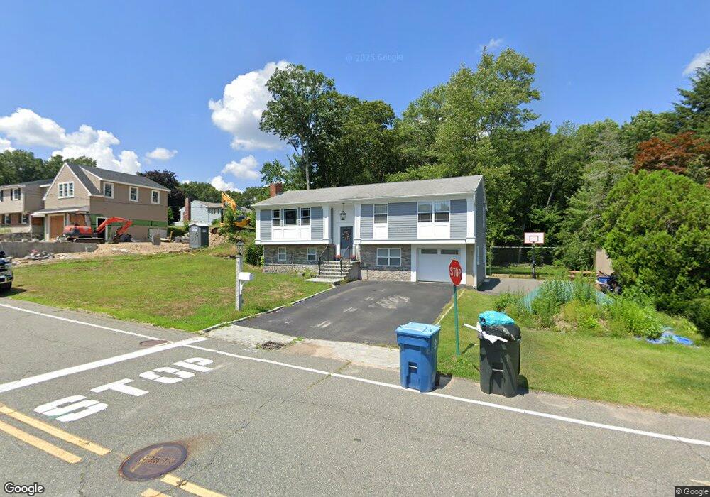
19 Fencourt Rd Canton, MA 02021
Estimated Value: $713,000 - $913,000
3
Beds
2
Baths
1,850
Sq Ft
$433/Sq Ft
Est. Value
About This Home
This home is located at 19 Fencourt Rd, Canton, MA 02021 and is currently estimated at $801,530, approximately $433 per square foot. 19 Fencourt Rd is a home located in Norfolk County with nearby schools including Canton High School and St. John the Evangelist School.
Ownership History
Date
Name
Owned For
Owner Type
Purchase Details
Closed on
Nov 20, 2018
Sold by
19 Fencourt Road Rt
Bought by
Noone Lydia and Brennan Edward
Current Estimated Value
Home Financials for this Owner
Home Financials are based on the most recent Mortgage that was taken out on this home.
Original Mortgage
$422,211
Outstanding Balance
$370,871
Interest Rate
4.75%
Mortgage Type
FHA
Estimated Equity
$430,659
Purchase Details
Closed on
Nov 29, 2013
Sold by
Togher Patrick and Togher Mary T
Bought by
19 Fencourt Raod Rt and Togher Patrick
Purchase Details
Closed on
Jul 31, 1997
Sold by
Glassman Elliot
Bought by
Togher Patrick and Togher Mary T
Home Financials for this Owner
Home Financials are based on the most recent Mortgage that was taken out on this home.
Original Mortgage
$50,000
Interest Rate
7.55%
Mortgage Type
Purchase Money Mortgage
Create a Home Valuation Report for This Property
The Home Valuation Report is an in-depth analysis detailing your home's value as well as a comparison with similar homes in the area
Home Values in the Area
Average Home Value in this Area
Purchase History
| Date | Buyer | Sale Price | Title Company |
|---|---|---|---|
| Noone Lydia | $430,000 | -- | |
| 19 Fencourt Raod Rt | -- | -- | |
| Togher Patrick | $205,000 | -- |
Source: Public Records
Mortgage History
| Date | Status | Borrower | Loan Amount |
|---|---|---|---|
| Open | Noone Lydia | $422,211 | |
| Previous Owner | Togher Patrick | $50,000 | |
| Previous Owner | Togher Patrick | $30,000 |
Source: Public Records
Tax History Compared to Growth
Tax History
| Year | Tax Paid | Tax Assessment Tax Assessment Total Assessment is a certain percentage of the fair market value that is determined by local assessors to be the total taxable value of land and additions on the property. | Land | Improvement |
|---|---|---|---|---|
| 2025 | $7,376 | $745,800 | $328,900 | $416,900 |
| 2024 | $7,493 | $751,600 | $345,000 | $406,600 |
| 2023 | $7,350 | $695,400 | $345,000 | $350,400 |
| 2022 | $6,959 | $613,100 | $328,600 | $284,500 |
| 2021 | $6,516 | $534,100 | $273,800 | $260,300 |
| 2020 | $5,829 | $476,600 | $260,800 | $215,800 |
| 2019 | $5,487 | $442,500 | $237,000 | $205,500 |
| 2018 | $5,286 | $425,600 | $227,900 | $197,700 |
| 2017 | $5,340 | $417,500 | $223,500 | $194,000 |
| 2016 | $5,246 | $410,200 | $218,000 | $192,200 |
| 2015 | $5,119 | $399,300 | $211,700 | $187,600 |
Source: Public Records
Map
Nearby Homes
- 859 Pleasant St
- 60 Coppersmith Way Unit 208
- 21 Pine St Unit E
- 23 Pine St Unit K
- 25 Pine St Unit B
- 4 Forge Pond Unit E
- 651 Washington St
- 717 Washington St Unit G
- 16 Danforth St
- 15 Audubon Way Unit 15
- 189 Bailey St
- 16 Meadowood Dr
- 185 Bailey St
- 19 Walnut Knolls
- 56 Laurelwood Dr
- 20 Audubon Way Unit 109
- 20 Audubon Way Unit 105
- 20 Audubon Way Unit 201
- 20 Audubon Way Unit 103
- 20 Audubon Way Unit 410