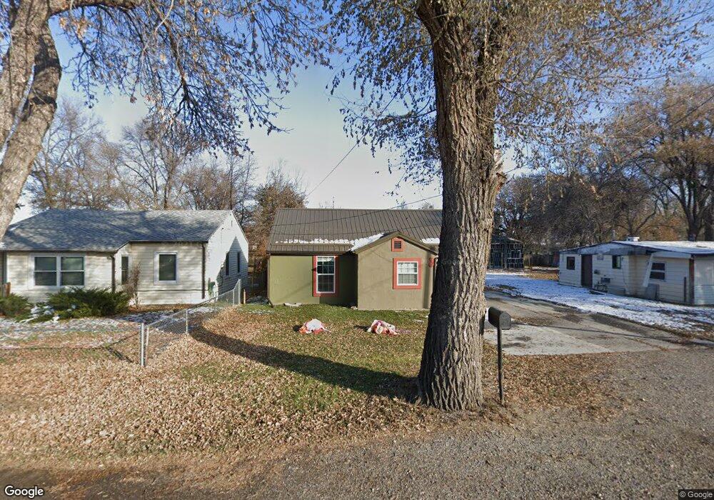
19 Rhea Ln Billings, MT 59102
East Central Billings NeighborhoodEstimated Value: $255,430 - $274,000
3
Beds
1
Bath
1,125
Sq Ft
$236/Sq Ft
Est. Value
About This Home
This home is located at 19 Rhea Ln, Billings, MT 59102 and is currently estimated at $265,108, approximately $235 per square foot. 19 Rhea Ln is a home located in Yellowstone County with nearby schools including Washington School, Lewis & Clark Junior High School, and Billings West High School.
Ownership History
Date
Name
Owned For
Owner Type
Purchase Details
Closed on
Feb 21, 2014
Sold by
Secretary Housing Urban Development
Bought by
Dvorak Richard
Current Estimated Value
Purchase Details
Closed on
Oct 21, 2013
Sold by
Victor Robert P
Bought by
Montana Board Of Housing
Purchase Details
Closed on
Dec 4, 2006
Sold by
Bowers Charles E and Bowers Kimberly R
Bought by
Victor Robert P
Home Financials for this Owner
Home Financials are based on the most recent Mortgage that was taken out on this home.
Original Mortgage
$72,110
Interest Rate
6.37%
Mortgage Type
FHA
Purchase Details
Closed on
Jul 26, 2005
Sold by
County Of Yellowstone
Bought by
Bowers Charles and Bowers Kimberly R
Purchase Details
Closed on
Feb 26, 2005
Sold by
County Of Yellowstone
Bought by
Bowers Charles and Bowers Kimberly R
Create a Home Valuation Report for This Property
The Home Valuation Report is an in-depth analysis detailing your home's value as well as a comparison with similar homes in the area
Home Values in the Area
Average Home Value in this Area
Purchase History
| Date | Buyer | Sale Price | Title Company |
|---|---|---|---|
| Dvorak Richard | -- | None Available | |
| Montana Board Of Housing | $71,966 | None Available | |
| Victor Robert P | -- | Stewart Title Of Billings | |
| Bowers Charles | -- | None Available | |
| Bowers Charles | -- | None Available |
Source: Public Records
Mortgage History
| Date | Status | Borrower | Loan Amount |
|---|---|---|---|
| Previous Owner | Victor Robert P | $72,110 |
Source: Public Records
Tax History Compared to Growth
Tax History
| Year | Tax Paid | Tax Assessment Tax Assessment Total Assessment is a certain percentage of the fair market value that is determined by local assessors to be the total taxable value of land and additions on the property. | Land | Improvement |
|---|---|---|---|---|
| 2025 | $1,851 | $220,100 | $40,016 | $180,084 |
| 2024 | $1,851 | $186,300 | $39,514 | $146,786 |
| 2023 | $1,899 | $186,300 | $39,514 | $146,786 |
| 2022 | $1,853 | $160,800 | $0 | $0 |
| 2021 | $1,805 | $160,800 | $0 | $0 |
| 2020 | $1,595 | $135,200 | $0 | $0 |
| 2019 | $1,525 | $135,200 | $0 | $0 |
| 2018 | $1,360 | $116,400 | $0 | $0 |
| 2017 | $758 | $116,400 | $0 | $0 |
| 2016 | $1,004 | $85,335 | $0 | $0 |
| 2015 | $981 | $85,335 | $0 | $0 |
| 2014 | $865 | $39,046 | $0 | $0 |
Source: Public Records
Map
Nearby Homes
- 626 Cook Ave
- 812 Miles Ave
- 1113 Lynn Ave
- 226 Moore Ln
- 112 11th St W
- 925 Miles Ave
- 927 Miles Ave
- 618 & 620 Howard Ave
- 141 S 12th St W
- 1122 Howard Ave
- 1019 Miles Ave
- 1212 Concord Dr
- 704 Terry Ave
- 231 S 12th St W
- 1231 Saint Johns Ave
- 1304 Eldorado Dr
- 418 Cook Ave
- 611 Custer Ave
- 4429 Lux Ave
- 626 Wyoming Ave