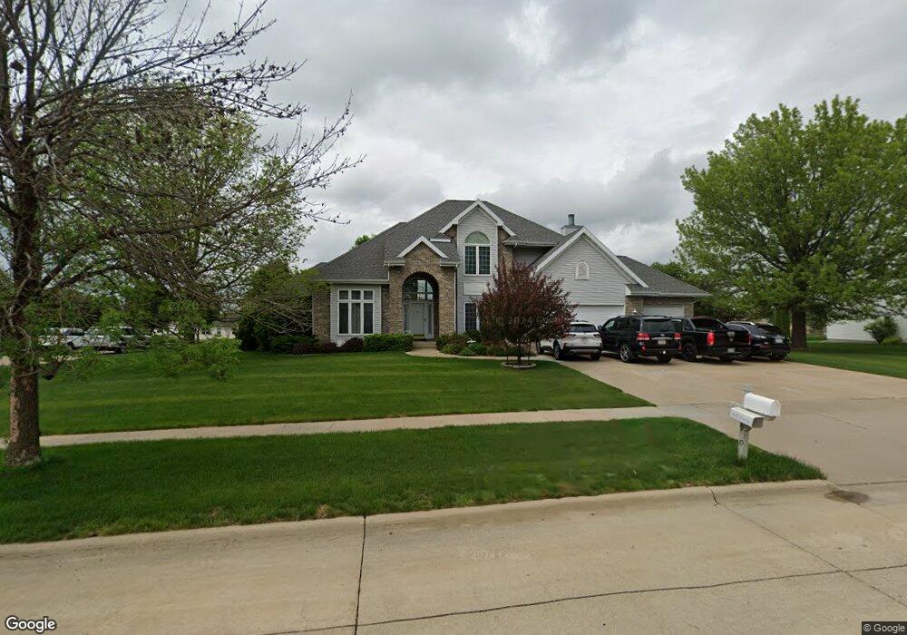
1900 Partridge Ln Waterloo, IA 50701
Audubon NeighborhoodEstimated Value: $457,327 - $578,000
4
Beds
3
Baths
3,136
Sq Ft
$165/Sq Ft
Est. Value
About This Home
This home is located at 1900 Partridge Ln, Waterloo, IA 50701 and is currently estimated at $518,832, approximately $165 per square foot. 1900 Partridge Ln is a home located in Black Hawk County with nearby schools including Orange Elementary School, Hoover Middle School, and West High School.
Ownership History
Date
Name
Owned For
Owner Type
Purchase Details
Closed on
Jul 25, 2013
Sold by
Zack Robert N and Zack Peggy P
Bought by
Wait Gerald M
Current Estimated Value
Home Financials for this Owner
Home Financials are based on the most recent Mortgage that was taken out on this home.
Original Mortgage
$32,500
Outstanding Balance
$8,035
Interest Rate
4.25%
Mortgage Type
Credit Line Revolving
Estimated Equity
$510,797
Create a Home Valuation Report for This Property
The Home Valuation Report is an in-depth analysis detailing your home's value as well as a comparison with similar homes in the area
Home Values in the Area
Average Home Value in this Area
Purchase History
We collect this data history from publicly available records. To have your information removed, we recommend requesting removal directly through your county’s website.
| Date | Buyer | Sale Price | Title Company |
|---|---|---|---|
| Wait Gerald M | $325,000 | Title Service Corp |
Source: Public Records
Mortgage History
We collect this data history from publicly available records. To have your information removed, we recommend requesting removal directly through your county’s website.
| Date | Status | Borrower | Loan Amount |
|---|---|---|---|
| Open | Wait Gerald M | $32,500 | |
| Open | Wait Gerald M | $292,500 |
Source: Public Records
Tax History
| Year | Tax Paid | Tax Assessment Tax Assessment Total Assessment is a certain percentage of the fair market value that is determined by local assessors to be the total taxable value of land and additions on the property. | Land | Improvement |
|---|---|---|---|---|
| 2025 | $7,964 | $438,270 | $60,550 | $377,720 |
| 2024 | $7,964 | $367,110 | $60,550 | $306,560 |
| 2023 | $6,430 | $367,110 | $60,550 | $306,560 |
| 2022 | $6,260 | $292,760 | $60,550 | $232,210 |
| 2021 | $7,392 | $292,760 | $60,550 | $232,210 |
| 2020 | $7,272 | $326,330 | $60,550 | $265,780 |
| 2019 | $7,272 | $326,330 | $60,550 | $265,780 |
| 2018 | $8,420 | $377,630 | $60,550 | $317,080 |
| 2017 | $8,672 | $377,630 | $60,550 | $317,080 |
| 2016 | $8,568 | $377,630 | $60,550 | $317,080 |
| 2015 | $8,568 | $377,630 | $60,550 | $317,080 |
| 2014 | $8,300 | $358,970 | $60,550 | $298,420 |
Source: Public Records
Map
Nearby Homes
- Lot 16 Red Tail Dr
- Lot 15 Red Tail Dr
- Lot 2 Red Tail Dr
- Lot 1 Red Tail Dr
- 122 Kestrel Cir
- 1703 Red Tail Dr
- 134 Sunbird Ct
- 1944 Kitty Hawk Dr
- 4222 Kris Line Dr
- 128 Goldcrest Ct
- 121 Goldcrest Ct
- 1925 Westchester Rd Unit 214
- 1900 Westchester Rd Unit C
- 4755 Winghaven Dr
- 0 Kimberly Ln Unit Lot 3
- 1828 Pinehurst Ln
- 4854 Yellowstone Dr
- Lot 2 - 3455 Marnie Ave - Lot for Sale
- Lot 1 - 3423 Marnie Ave - Lot for Sale
- 3454 Georgetown Dr
- 1850 Partridge Ln
- 1901 Partridge Ln
- 1857 Partridge Ln
- 1867 Red Tail Dr
- 4115 Harbin Dr Unit 1
- 4115 Harbin Dr Unit 4117
- 1877 Red Tail Dr
- 1840 Partridge Ln
- 1911 Partridge Ln
- 1889 Red Tail Dr
- 1857 Red Tail Dr
- Red Tail Lot 20 Dr
- 1845 Partridge Ln
- 1934 Partridge Ln
- 1845 Red Tail Dr
- 1836 Red Tail Dr
- 1834 Red Tail Dr
- 1900 Audubon Dr
- 1921 Partridge Ln
- Red Tail Lot 19 Dr
Your Personal Tour Guide
Ask me questions while you tour the home.