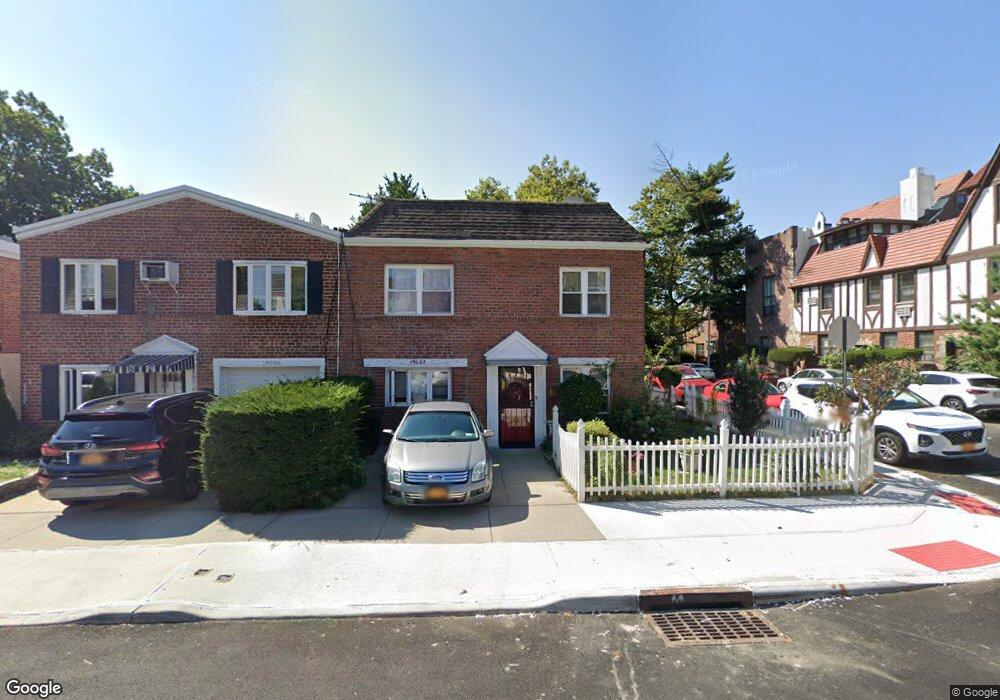
19002 37th Ave Flushing, NY 11358
Auburndale NeighborhoodEstimated Value: $930,000 - $1,173,000
Studio
--
Bath
1,800
Sq Ft
$562/Sq Ft
Est. Value
About This Home
This home is located at 19002 37th Ave, Flushing, NY 11358 and is currently estimated at $1,011,296, approximately $561 per square foot. 19002 37th Ave is a home located in Queens County with nearby schools including P.S. 32 - State Street, I.S. 25 Adrien Block, and Francis Lewis High School.
Ownership History
Date
Name
Owned For
Owner Type
Purchase Details
Closed on
Jan 23, 1998
Sold by
Renne James M and Renne Melinda B
Bought by
Zikas Christine
Current Estimated Value
Home Financials for this Owner
Home Financials are based on the most recent Mortgage that was taken out on this home.
Original Mortgage
$160,000
Outstanding Balance
$27,181
Interest Rate
6.9%
Estimated Equity
$984,115
Create a Home Valuation Report for This Property
The Home Valuation Report is an in-depth analysis detailing your home's value as well as a comparison with similar homes in the area
Home Values in the Area
Average Home Value in this Area
Purchase History
| Date | Buyer | Sale Price | Title Company |
|---|---|---|---|
| Zikas Christine | $210,000 | First American Title Ins Co |
Source: Public Records
Mortgage History
| Date | Status | Borrower | Loan Amount |
|---|---|---|---|
| Open | Zikas Christine | $160,000 |
Source: Public Records
Tax History
| Year | Tax Paid | Tax Assessment Tax Assessment Total Assessment is a certain percentage of the fair market value that is determined by local assessors to be the total taxable value of land and additions on the property. | Land | Improvement |
|---|---|---|---|---|
| 2025 | $9,515 | $48,522 | $15,390 | $33,132 |
| 2024 | $9,515 | $47,376 | $16,205 | $31,171 |
| 2023 | $9,125 | $45,430 | $13,136 | $32,294 |
| 2022 | $8,556 | $62,760 | $17,280 | $45,480 |
| 2021 | $8,510 | $53,220 | $17,280 | $35,940 |
| 2020 | $8,559 | $55,440 | $17,280 | $38,160 |
| 2019 | $8,259 | $57,360 | $17,280 | $40,080 |
| 2018 | $7,717 | $37,858 | $13,216 | $24,642 |
| 2017 | $7,281 | $35,716 | $13,187 | $22,529 |
| 2016 | $6,736 | $35,716 | $13,187 | $22,529 |
| 2015 | $3,844 | $33,696 | $14,690 | $19,006 |
| 2014 | $3,844 | $32,900 | $17,203 | $15,697 |
Source: Public Records
Map
Nearby Homes
- 189-23 39th Ave Unit 122
- 190-05 39th Ave Unit 140
- 190-05 39th Ave Unit 142
- 36-20 190th St
- 191-02 39th Ave
- 191-9 39th Ave Unit 164
- 191-08 Station Rd
- 19112 Station Rd
- 192-14 Station Rd
- 36-35 171st St Unit 30
- 3639 171st St Unit 26
- 190-17 42nd Ave
- 36-07 171st St Unit 35
- 36-20 194th St Unit 3r
- 42-25 189th St
- 3617 194th St
- 4038 194th St Unit 3B
- 40-38 194th St Unit A-1
- 194-23 Station Rd
- 4048 194th St Unit A3
- 19006 37th Ave
- 19006 37th Ave
- 190-06 37th Ave
- 19008 37th Ave
- 190-08 37th Ave
- 3708 190th St Unit 1F
- 3708 190th St
- 3708 190th St
- 37-08 190th St Unit 1F
- 3715 190th St Unit Lower
- 3715 190th St Unit 135
- 3715 190th St
- 3715 190th St
- 3715 190th St Unit 2nd Fl
- 3715 190th St Unit 2nd Fl
- 190-12 37th Ave Unit 2FL
- 190-12 37th Ave Unit 1FL
- 19012 37th Ave
- 37-06 190th St Unit 13
- 18938 37th Ave
Your Personal Tour Guide
Ask me questions while you tour the home.