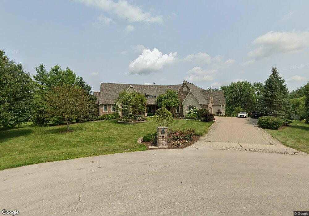
1901 Devonshire Ct Oswego, IL 60543
South Oswego NeighborhoodEstimated Value: $1,245,692 - $2,334,000
5
Beds
5
Baths
8,000
Sq Ft
$215/Sq Ft
Est. Value
About This Home
This home is located at 1901 Devonshire Ct, Oswego, IL 60543 and is currently estimated at $1,722,897, approximately $215 per square foot. 1901 Devonshire Ct is a home located in Kendall County with nearby schools including Hunt Club Elementary School, Murphy Junior High School, and Oswego East High School.
Ownership History
Date
Name
Owned For
Owner Type
Purchase Details
Closed on
Dec 18, 2009
Sold by
North Star Trust Company
Bought by
Martin Bradley S and Martin Cara L
Current Estimated Value
Home Financials for this Owner
Home Financials are based on the most recent Mortgage that was taken out on this home.
Original Mortgage
$937,500
Interest Rate
4.75%
Mortgage Type
New Conventional
Purchase Details
Closed on
Mar 12, 2004
Sold by
Old Second National Bank
Bought by
Harris Trust & Savings Bank and Trust #Nap-1110
Purchase Details
Closed on
Jan 19, 1999
Sold by
American National Bk&Tr Co Of Chicago
Bought by
The Old Second National Bank Of Aurora
Create a Home Valuation Report for This Property
The Home Valuation Report is an in-depth analysis detailing your home's value as well as a comparison with similar homes in the area
Home Values in the Area
Average Home Value in this Area
Purchase History
| Date | Buyer | Sale Price | Title Company |
|---|---|---|---|
| Martin Bradley S | $1,565,000 | None Available | |
| Harris Trust & Savings Bank | $200,000 | Chicago Title Insurance Co | |
| The Old Second National Bank Of Aurora | $140,000 | Ticor Title Insurance |
Source: Public Records
Mortgage History
| Date | Status | Borrower | Loan Amount |
|---|---|---|---|
| Previous Owner | Martin Bradley S | $937,500 |
Source: Public Records
Tax History
| Year | Tax Paid | Tax Assessment Tax Assessment Total Assessment is a certain percentage of the fair market value that is determined by local assessors to be the total taxable value of land and additions on the property. | Land | Improvement |
|---|---|---|---|---|
| 2024 | $24,175 | $329,165 | $37,672 | $291,493 |
| 2023 | $23,034 | $298,644 | $35,879 | $262,765 |
| 2022 | $23,034 | $277,103 | $32,315 | $244,788 |
| 2021 | $24,171 | $281,323 | $32,807 | $248,516 |
| 2020 | $23,653 | $271,427 | $32,344 | $239,083 |
| 2019 | $23,399 | $264,446 | $31,512 | $232,934 |
| 2018 | $23,125 | $250,969 | $29,906 | $221,063 |
| 2017 | $21,997 | $233,651 | $29,906 | $203,745 |
| 2016 | $10,293 | $216,103 | $29,537 | $186,566 |
| 2015 | $10,712 | $214,598 | $28,032 | $186,566 |
| 2014 | -- | $195,868 | $28,032 | $167,836 |
| 2013 | -- | $195,868 | $28,032 | $167,836 |
Source: Public Records
Map
Nearby Homes
- 1813 Winchester Ct
- 1651 Johnson Rd
- 100 acres Cherry Rd
- 27009 Ashgate Crossing
- 26918 Summergrove Dr
- 13006 Timber Wood Cir
- 27016 Thornwood Blvd
- 13005 Timber Wood Cir
- 13521 Arborview Cir
- 13550 S Coronado Cir
- 27100 Timber Wood Ct
- 13526 Coronado Cir
- 13542 S Coronado Cir
- 13522 S Coronado Cir
- 13530 S Coronado Cir
- 13550 Coronado Cir
- 13546 Coronado Cir
- 13530 Coronado Cir
- 13534 Coronado Cir
- 13522 Coronado Cir
- 1904 Devonshire Ct
- 1960 Devonshire Ct
- Lot 17 Devonshire Ct
- 6304 Southfield Ln
- 1824 Winchester Ct
- 2017 Devonshire Ct
- 1860 Winchester Ct
- 1898 Winchester Ct
- 1912 Cherry Rd
- 2018 Devonshire Ct
- 1812 Cherry Rd
- 1962 Cherry Rd
- 1934 Winchester Ct
- 6239 Southfield Ln
- 1751 Cherry Rd
- 1760 Cherry Rd
- 6285 Southfield Ln
- 6427 Southfield Ln
- 6381 Southfield Ln
- 1875 Winchester Ct
Your Personal Tour Guide
Ask me questions while you tour the home.