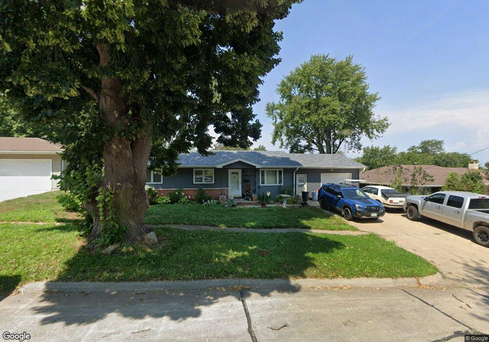
1905 Hillcrest Dr Atlantic, IA 50022
Estimated Value: $190,000 - $207,920
3
Beds
3
Baths
1,071
Sq Ft
$185/Sq Ft
Est. Value
About This Home
This home is located at 1905 Hillcrest Dr, Atlantic, IA 50022 and is currently estimated at $198,480, approximately $185 per square foot. 1905 Hillcrest Dr is a home located in Cass County with nearby schools including Washington Elementary School, Schuler Elementary School, and Atlantic Middle School.
Ownership History
Date
Name
Owned For
Owner Type
Purchase Details
Closed on
Aug 3, 2020
Sold by
Price Laurine
Bought by
Price Joseph M
Current Estimated Value
Home Financials for this Owner
Home Financials are based on the most recent Mortgage that was taken out on this home.
Original Mortgage
$117,700
Outstanding Balance
$104,173
Interest Rate
3%
Mortgage Type
New Conventional
Estimated Equity
$94,307
Create a Home Valuation Report for This Property
The Home Valuation Report is an in-depth analysis detailing your home's value as well as a comparison with similar homes in the area
Home Values in the Area
Average Home Value in this Area
Purchase History
| Date | Buyer | Sale Price | Title Company |
|---|---|---|---|
| Price Joseph M | $124,000 | None Available |
Source: Public Records
Mortgage History
| Date | Status | Borrower | Loan Amount |
|---|---|---|---|
| Open | Price Joseph M | $117,700 |
Source: Public Records
Tax History Compared to Growth
Tax History
| Year | Tax Paid | Tax Assessment Tax Assessment Total Assessment is a certain percentage of the fair market value that is determined by local assessors to be the total taxable value of land and additions on the property. | Land | Improvement |
|---|---|---|---|---|
| 2024 | $2,810 | $166,470 | $15,880 | $150,590 |
| 2023 | $2,342 | $166,470 | $15,880 | $150,590 |
| 2022 | $2,300 | $118,130 | $14,800 | $103,330 |
| 2021 | $2,300 | $118,130 | $14,800 | $103,330 |
| 2020 | $1,918 | $95,340 | $14,800 | $80,540 |
| 2019 | $2,078 | $97,330 | $0 | $0 |
| 2018 | $2,048 | $97,330 | $0 | $0 |
| 2017 | $2,122 | $97,330 | $0 | $0 |
| 2016 | $2,088 | $97,330 | $0 | $0 |
| 2015 | $2,146 | $100,680 | $0 | $0 |
| 2014 | $2,164 | $100,680 | $0 | $0 |
Source: Public Records
Map
Nearby Homes
- 605 E 19th St
- 1406 E 20th St
- 1404 E 20th St
- 1409 E 20th St
- 1407 E 20th St
- 611 E 18th St
- 1801 Bryn Mawr Blvd
- 1603 Olive St
- 1603 Bryn Mawr Blvd
- 1806 Sycamore Ave
- 104 E 22nd St
- 1508 Roosevelt Dr
- 9 Ridge Rd
- 1410 Mulberry St
- 1314 Chestnut St
- 1304 Chestnut St
- 2004 Southern View Dr
- 1303 Chestnut St
- 1200 Chestnut St
- 1301 Plum St
- 1903 Hillcrest Dr
- 2001 Hillcrest Dr
- 1906 Oak St
- 1904 Oak St
- 1901 Hillcrest Dr
- 600 E 20th St
- 2005 Hillcrest Dr
- 1908 Oak St
- 2000 Hillcrest Dr
- 1902 Hillcrest Dr
- 1805 Hillcrest Dr
- 1900 Hillcrest Dr
- 1902 Oak St
- 2002 Oak St
- 2006 Hillcrest Dr
- 1900 Oak St
- 2009 Hillcrest Dr
- 404 E 21st St
- 1803 Hillcrest Dr
- 603 E 20 St