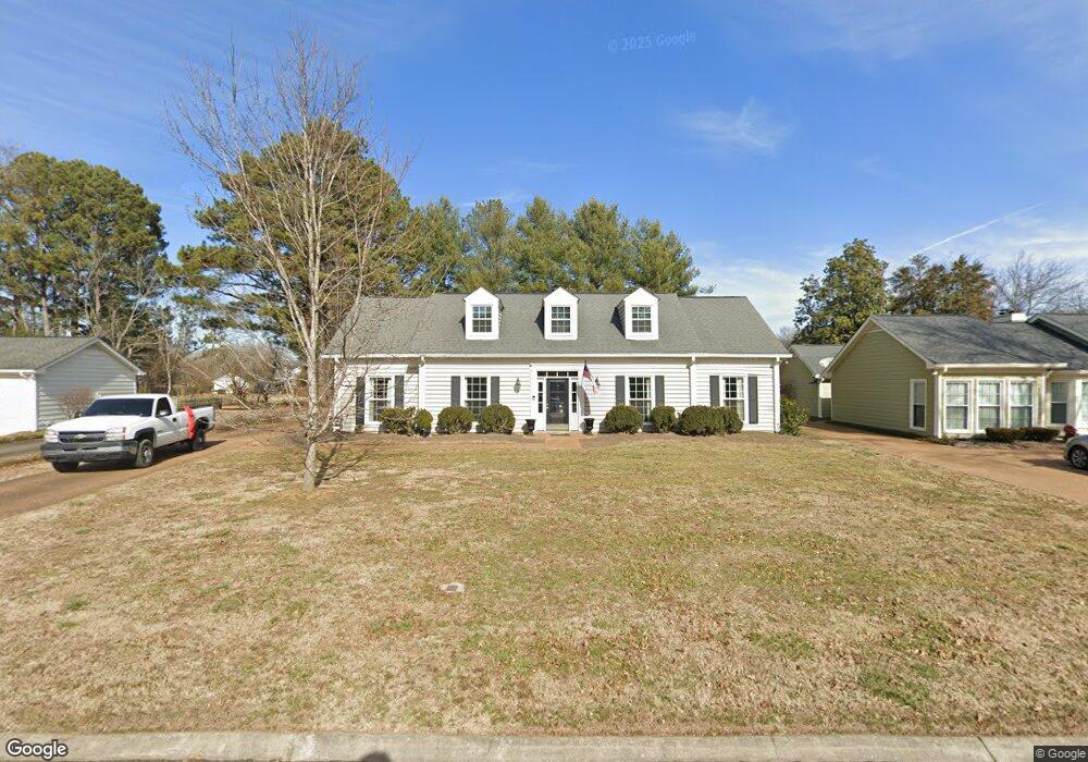
1907 Sam Houston Ct Franklin, TN 37069
Estimated Value: $679,000 - $832,000
Studio
3
Baths
2,354
Sq Ft
$308/Sq Ft
Est. Value
About This Home
This home is located at 1907 Sam Houston Ct, Franklin, TN 37069 and is currently estimated at $725,311, approximately $308 per square foot. 1907 Sam Houston Ct is a home located in Williamson County with nearby schools including Grassland Elementary School, Grassland Middle School, and Franklin High School.
Ownership History
Date
Name
Owned For
Owner Type
Purchase Details
Closed on
Oct 28, 2011
Sold by
Richter Sara Linn
Bought by
Richter Sara Linn and Sara Linn Richter Living Trust
Current Estimated Value
Purchase Details
Closed on
Jun 21, 2010
Sold by
Richter Robert L
Bought by
Richter Sara Nell Linn
Purchase Details
Closed on
Dec 23, 2009
Sold by
Teal Jerry L
Bought by
Richter Robert L and Richter Sara Nell Linn
Purchase Details
Closed on
Aug 1, 2005
Sold by
Chrismer Rosalind L
Bought by
Teal Jerry L
Purchase Details
Closed on
Sep 25, 2003
Sold by
Teal Jerry L
Bought by
Chrismer Rosalind L
Purchase Details
Closed on
Sep 3, 2003
Sold by
Chrismer Rosalind L
Bought by
Teal Jerry L
Create a Home Valuation Report for This Property
The Home Valuation Report is an in-depth analysis detailing your home's value as well as a comparison with similar homes in the area
Purchase History
| Date | Buyer | Sale Price | Title Company |
|---|---|---|---|
| Richter Sara Linn | -- | None Available | |
| Richter Sara Nell Linn | -- | None Available | |
| Richter Robert L | $240,000 | Tennessee Title Services Llc | |
| Teal Jerry L | -- | -- | |
| Chrismer Rosalind L | -- | Title Enterprise Svc Co Llc | |
| Teal Jerry L | -- | Title Enterprises Service Co |
Source: Public Records
Tax History
| Year | Tax Paid | Tax Assessment Tax Assessment Total Assessment is a certain percentage of the fair market value that is determined by local assessors to be the total taxable value of land and additions on the property. | Land | Improvement |
|---|---|---|---|---|
| 2025 | $1,980 | $171,350 | $87,500 | $83,850 |
| 2024 | $1,980 | $105,325 | $35,000 | $70,325 |
| 2023 | $1,980 | $105,325 | $35,000 | $70,325 |
| 2022 | $1,980 | $105,325 | $35,000 | $70,325 |
| 2021 | $1,980 | $105,325 | $35,000 | $70,325 |
| 2020 | $1,833 | $82,575 | $22,500 | $60,075 |
| 2019 | $1,833 | $82,575 | $22,500 | $60,075 |
| 2018 | $1,775 | $82,575 | $22,500 | $60,075 |
| 2017 | $1,775 | $82,575 | $22,500 | $60,075 |
| 2016 | $1,775 | $82,575 | $22,500 | $60,075 |
Source: Public Records
Map
Nearby Homes
- 2006 Boxwood Dr
- 1015 Boxwood Dr
- 1008 Boxwood Dr
- 1009 Boxwood Dr
- 2418 Mcintyre Ct
- 149 Boxwood Dr Unit 149
- 2109 Key Dr
- 116 Gardengate Dr
- 1462 Sneed Rd W
- 206 Gardenridge Dr
- 2002 Sunny Side Dr
- 1986 Sunny Side Dr
- 2410 Hidden River Ln
- 1224 Waterstone Blvd
- 200 Overlook Dr
- 1961 Sunny Side Dr
- 0 Gen J B Hood Dr
- 410 Bobby Dr
- 1065 Stockett Dr
- 1019 Stockett Dr
- 1905 Sam Houston Ct
- 1909 Sam Houston Ct
- 1903 Sam Houston Ct
- 1911 Sam Houston Ct
- 1904 Sam Houston Ct
- 1906 Sam Houston Ct
- 1902 Sam Houston Ct
- 1908 Sam Houston Ct
- 2000 Boxwood Dr
- 2002 Boxwood Dr
- 1071 Moran Rd
- 1075 Moran Rd
- 2004 Boxwood Dr
- 1910 Sam Houston Ct
- 1067 Moran Rd
- 1079 Moran Rd
- 1915 Sam Houston Ct
- 1063 Moran Rd
- 1912 Sam Houston Ct
- 1083 Moran Rd
Your Personal Tour Guide
Ask me questions while you tour the home.