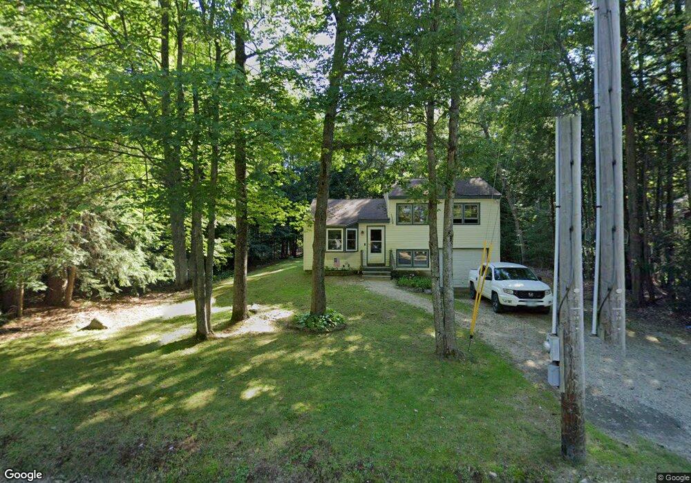
191 Varney Rd Center Barnstead, NH 03225
Estimated Value: $313,667 - $352,000
2
Beds
1
Bath
1,006
Sq Ft
$327/Sq Ft
Est. Value
About This Home
This home is located at 191 Varney Rd, Center Barnstead, NH 03225 and is currently estimated at $329,417, approximately $327 per square foot. 191 Varney Rd is a home with nearby schools including Barnstead Elementary School and Prospect Mountain High School.
Ownership History
Date
Name
Owned For
Owner Type
Purchase Details
Closed on
Aug 21, 1998
Sold by
Tiede Rental Inc
Bought by
Hoyt Randolph W and Hoyt Michelle I
Current Estimated Value
Home Financials for this Owner
Home Financials are based on the most recent Mortgage that was taken out on this home.
Original Mortgage
$52,000
Outstanding Balance
$9,664
Interest Rate
6.86%
Estimated Equity
$319,753
Create a Home Valuation Report for This Property
The Home Valuation Report is an in-depth analysis detailing your home's value as well as a comparison with similar homes in the area
Home Values in the Area
Average Home Value in this Area
Purchase History
| Date | Buyer | Sale Price | Title Company |
|---|---|---|---|
| Hoyt Randolph W | $65,000 | -- |
Source: Public Records
Mortgage History
| Date | Status | Borrower | Loan Amount |
|---|---|---|---|
| Open | Hoyt Randolph W | $52,000 |
Source: Public Records
Tax History
| Year | Tax Paid | Tax Assessment Tax Assessment Total Assessment is a certain percentage of the fair market value that is determined by local assessors to be the total taxable value of land and additions on the property. | Land | Improvement |
|---|---|---|---|---|
| 2025 | $4,380 | $255,400 | $108,000 | $147,400 |
| 2024 | $4,166 | $255,400 | $108,000 | $147,400 |
| 2023 | $3,665 | $255,400 | $108,000 | $147,400 |
| 2022 | $3,361 | $155,600 | $55,300 | $100,300 |
| 2021 | $3,417 | $155,600 | $55,300 | $100,300 |
| 2020 | $3,733 | $161,600 | $55,300 | $106,300 |
| 2019 | $3,689 | $161,600 | $55,300 | $106,300 |
| 2018 | $3,596 | $161,600 | $55,300 | $106,300 |
| 2017 | $3,248 | $112,400 | $33,400 | $79,000 |
| 2016 | $3,063 | $112,400 | $33,400 | $79,000 |
| 2015 | $3,052 | $112,400 | $33,400 | $79,000 |
| 2014 | $3,026 | $126,300 | $42,400 | $83,900 |
| 2013 | $2,968 | $126,300 | $42,400 | $83,900 |
Source: Public Records
Map
Nearby Homes
- 184 Varney Rd
- 180 Varney Rd
- 222 Varney Rd
- 101 Rogers Rd
- 37446 N Shore Washington Dr
- 1 Wentworth Ln
- 157 Georgetown Dr
- 91 Bradford Ln
- 28 Dalton Dr
- 15 Davis Dr
- 7 Sampson Dr
- 61 Crescent Dr
- 96 Damsite Rd
- 55 Walker Rd
- 10 Circle Dr
- 71 Windsor Way
- 0 Andover Dr Unit 106 5059711
- 24 Danbury Rd
- 58 Windsor Way
- 11b Bow Mills Rd
- 189 Varney Rd
- 0 Varney Rd Unit 2750684
- 188 Varney Rd
- 198 Varney Rd
- 58 Winchester Dr
- 202 Varney Rd
- 3 Bristol Rd
- 181 Varney Rd
- Map 42 Lot 328 Bristol Rd
- Lot 242 Varney Rd
- Lot 328 Bristol Rd Unit m41/l328
- Lot 328 Bristol Rd
- 47 Winchester Dr
- 206 Varney Rd
- 206 Varney Rd
- 41 Winchester Dr
- 175 Varney Rd
- 176 Varney Rd
- 10 Westchester Park
- 209 Varney Rd
Your Personal Tour Guide
Ask me questions while you tour the home.