Estimated Value: $242,000 - $317,000
2
Beds
1
Bath
1,008
Sq Ft
$281/Sq Ft
Est. Value
About This Home
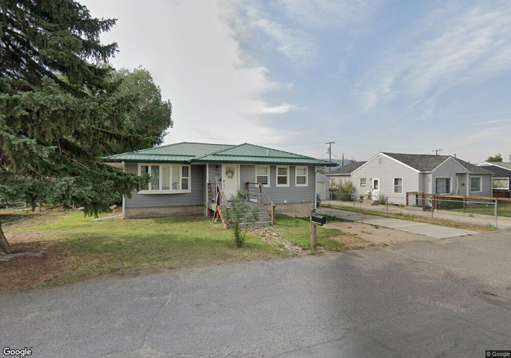
This home is located at 1916 C St, Butte, MT 59701 and is currently estimated at $282,966, approximately $280 per square foot. 1916 C St is a home located in Silver Bow County with nearby schools including Emerson School, East Middle School, and Butte High School.
Ownership History
Date
Name
Owned For
Owner Type
Purchase Details
Closed on
Oct 11, 2019
Sold by
Leyes Michele R and Vidrick Michele R
Bought by
Salminen Lexi R
Current Estimated Value
Home Financials for this Owner
Home Financials are based on the most recent Mortgage that was taken out on this home.
Original Mortgage
$169,750
Outstanding Balance
$148,710
Interest Rate
3.5%
Mortgage Type
New Conventional
Estimated Equity
$134,256
Purchase Details
Closed on
Mar 11, 2008
Sold by
Vidrich David M
Bought by
Vidrich Michelle R
Create a Home Valuation Report for This Property
The Home Valuation Report is an in-depth analysis detailing your home's value as well as a comparison with similar homes in the area
Purchase History
| Date | Buyer | Sale Price | Title Company |
|---|---|---|---|
| Salminen Lexi R | -- | None Available | |
| Vidrich Michelle R | -- | -- |
Source: Public Records
Mortgage History
| Date | Status | Borrower | Loan Amount |
|---|---|---|---|
| Open | Salminen Lexi R | $169,750 |
Source: Public Records
Tax History
| Year | Tax Paid | Tax Assessment Tax Assessment Total Assessment is a certain percentage of the fair market value that is determined by local assessors to be the total taxable value of land and additions on the property. | Land | Improvement |
|---|---|---|---|---|
| 2025 | $2,813 | $296,400 | $0 | $0 |
| 2024 | $3,059 | $231,000 | $0 | $0 |
| 2023 | $3,042 | $231,000 | $0 | $0 |
| 2022 | $2,706 | $151,400 | $0 | $0 |
| 2021 | $2,754 | $151,400 | $0 | $0 |
| 2020 | $2,718 | $142,300 | $0 | $0 |
| 2019 | $2,616 | $134,900 | $0 | $0 |
| 2018 | $2,527 | $131,600 | $0 | $0 |
| 2017 | $1,336 | $131,600 | $0 | $0 |
| 2016 | $2,145 | $107,600 | $0 | $0 |
| 2015 | $1,134 | $107,600 | $0 | $0 |
| 2014 | $2,003 | $55,756 | $0 | $0 |
Source: Public Records
Map
Nearby Homes
- 1806 C St
- 1801 Yale Ave
- 1727 A St
- 2210 Massachusetts Ave
- 2223 Princeton St
- 2007 Florida Ave
- 2250 Cross Dr
- 2319 Princeton St
- 2000 Massachusetts Ave
- 1863 Dewey Blvd
- 1408 C St
- 1636 Schley Ave
- 1875 Harrison Ave
- 2410 Yale Ave
- 2420 Harvard Ave
- TBD Princeton St
- 2040 Adams Ave
- 3001 Busch St
- 1401 Sampson St
- 1610 Gilman Ave
- 1914 C St
- 1959 Princeton St
- 1937 Princeton St
- 1925 Princeton St
- 1912 C St
- 1963 Princeton St
- 1921 Princeton St
- 1910 C St
- 1967 Princeton St
- 1911 Princeton St
- 1907 C St
- 2407 Harrison Ave
- 1900 C St
- 1958 Princeton St
- 1952 Princeton St
- 1901 Princeton St
- 1901 C St
- 1950 Princeton St
- 1968 Princeton St
- 1836 C St
Your Personal Tour Guide
Ask me questions while you tour the home.