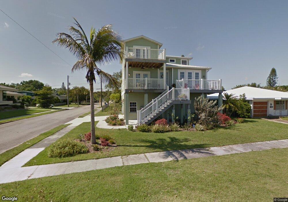
1916 Riverside Dr E Bradenton, FL 34208
Samoset NeighborhoodEstimated Value: $660,000 - $1,049,000
4
Beds
3
Baths
2,552
Sq Ft
$330/Sq Ft
Est. Value
About This Home
This home is located at 1916 Riverside Dr E, Bradenton, FL 34208 and is currently estimated at $843,113, approximately $330 per square foot. 1916 Riverside Dr E is a home located in Manatee County with nearby schools including Manatee Elementary School, Manatee High School, and Martha B. King Middle School.
Ownership History
Date
Name
Owned For
Owner Type
Purchase Details
Closed on
Jul 28, 2009
Sold by
Morrison Jonl C
Bought by
Morrison Jonl C and Morrison Valerie
Current Estimated Value
Home Financials for this Owner
Home Financials are based on the most recent Mortgage that was taken out on this home.
Original Mortgage
$300,000
Interest Rate
5.36%
Mortgage Type
Purchase Money Mortgage
Create a Home Valuation Report for This Property
The Home Valuation Report is an in-depth analysis detailing your home's value as well as a comparison with similar homes in the area
Home Values in the Area
Average Home Value in this Area
Purchase History
| Date | Buyer | Sale Price | Title Company |
|---|---|---|---|
| Morrison Jonl C | $148,500 | Hometown Title Agency Inc |
Source: Public Records
Mortgage History
| Date | Status | Borrower | Loan Amount |
|---|---|---|---|
| Closed | Morrison Jonl C | $300,000 |
Source: Public Records
Tax History
| Year | Tax Paid | Tax Assessment Tax Assessment Total Assessment is a certain percentage of the fair market value that is determined by local assessors to be the total taxable value of land and additions on the property. | Land | Improvement |
|---|---|---|---|---|
| 2025 | $7,918 | $483,823 | -- | -- |
| 2023 | $7,831 | $456,493 | $0 | $0 |
| 2022 | $7,655 | $443,197 | $0 | $0 |
| 2021 | $7,304 | $428,444 | $0 | $0 |
| 2020 | $7,539 | $422,529 | $0 | $0 |
| 2019 | $7,419 | $413,029 | $97,500 | $315,529 |
| 2018 | $7,654 | $420,655 | $0 | $0 |
| 2017 | $7,195 | $412,003 | $0 | $0 |
| 2016 | $7,157 | $403,529 | $0 | $0 |
| 2015 | $7,403 | $400,724 | $0 | $0 |
| 2014 | $7,403 | $406,787 | $0 | $0 |
| 2013 | $7,363 | $400,775 | $0 | $0 |
Source: Public Records
Map
Nearby Homes
- 1910 Riverside Dr E
- 2014 Riverside Dr E
- 102 20th St NE
- 211 21st St NE
- 1906 2nd Ave E
- 218 22nd St NE
- 1915 3rd Ave E
- 1929 3rd Ave E
- 118 18th St E
- 1840 3rd Ave E
- 204 22nd Street Ct NE
- 107 22nd St E
- 208 22nd Street Ct NE
- 102 17th St NE
- 103 17th St E
- 210 22nd Street Ct NE
- 2326 2nd Ave E
- 1706 4th Ave E
- 1631 4th Ave E
- 520 20th St E
- 1914 Riverside Dr E
- 1912 Riverside Dr E
- 2002 Riverside Dr E
- 1923 Saint George Dr
- 1919 Saint George Dr
- 2001 Saint George Dr
- 2008 Riverside Dr E
- 1908 Riverside Dr E
- 1917 Saint George Dr
- 0 20th St E Unit M5839458
- 2005 Saint George Dr
- 1906 Riverside Dr E
- 1915 Saint George Dr
- 1922 Saint George Dr
- 1902 Riverside Dr E
- 1918 St George Dr
- 1918 Saint George Dr
- 107 20th St NE
- 2015 Saint George Dr
- 2004 Saint George Dr
Your Personal Tour Guide
Ask me questions while you tour the home.