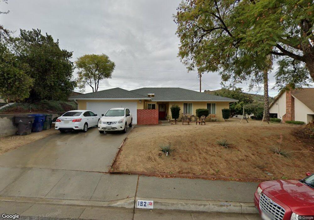
192 E Manfield St Riverside, CA 92507
University NeighborhoodEstimated Value: $588,428 - $679,000
4
Beds
2
Baths
1,596
Sq Ft
$399/Sq Ft
Est. Value
About This Home
This home is located at 192 E Manfield St, Riverside, CA 92507 and is currently estimated at $637,107, approximately $399 per square foot. 192 E Manfield St is a home located in Riverside County with nearby schools including Highland Elementary, University Heights Middle School, and John W. North High School.
Ownership History
Date
Name
Owned For
Owner Type
Purchase Details
Closed on
Dec 29, 2009
Sold by
Burrell Teresa M
Bought by
The Teresa M Burrell Intervivos Trust
Current Estimated Value
Purchase Details
Closed on
Jan 2, 1996
Sold by
Jeppson Lee R and Jeppson Starr M
Bought by
Burrell Teresa M
Home Financials for this Owner
Home Financials are based on the most recent Mortgage that was taken out on this home.
Original Mortgage
$80,000
Interest Rate
7.14%
Mortgage Type
Purchase Money Mortgage
Create a Home Valuation Report for This Property
The Home Valuation Report is an in-depth analysis detailing your home's value as well as a comparison with similar homes in the area
Home Values in the Area
Average Home Value in this Area
Purchase History
| Date | Buyer | Sale Price | Title Company |
|---|---|---|---|
| The Teresa M Burrell Intervivos Trust | -- | None Available | |
| Burrell Teresa M | $200,000 | Northern Counties Title |
Source: Public Records
Mortgage History
| Date | Status | Borrower | Loan Amount |
|---|---|---|---|
| Previous Owner | Burrell Teresa M | $80,000 |
Source: Public Records
Tax History
| Year | Tax Paid | Tax Assessment Tax Assessment Total Assessment is a certain percentage of the fair market value that is determined by local assessors to be the total taxable value of land and additions on the property. | Land | Improvement |
|---|---|---|---|---|
| 2025 | $1,848 | $166,086 | $58,125 | $107,961 |
| 2023 | $1,848 | $159,639 | $55,869 | $103,770 |
| 2022 | $1,807 | $156,510 | $54,774 | $101,736 |
| 2021 | $1,796 | $153,442 | $53,700 | $99,742 |
| 2020 | $1,783 | $151,870 | $53,150 | $98,720 |
| 2019 | $1,750 | $148,893 | $52,108 | $96,785 |
| 2018 | $1,717 | $145,975 | $51,087 | $94,888 |
| 2017 | $1,687 | $143,114 | $50,086 | $93,028 |
| 2016 | $1,582 | $140,308 | $49,104 | $91,204 |
| 2015 | $1,559 | $138,202 | $48,367 | $89,835 |
| 2014 | $1,544 | $135,496 | $47,420 | $88,076 |
Source: Public Records
Map
Nearby Homes
- 4495 Mt Vernon Ave
- 4360 Watkins Dr
- 134 W Broadbent Dr
- 20682 Hill Top Dr
- 7 Gage
- 0 Pettegrew Rd Unit IV25281686
- 511 Athens St
- 20079 Westpoint Dr
- 375 Central Ave Unit 124
- 375 Central Ave Unit 78
- 375 Central Ave Unit 14
- 375 Central Ave Unit 24
- 375 Central Ave Unit 83
- 20995 Mountain Gate Dr
- 20996 Mountain Gate Dr
- 5110 Caldera Ct
- 5423 Canmore Ct
- 3314 Celeste Dr
- 0 Harvard Way
- 20517 Claremont Ave
- 182 E Manfield St
- 202 E Manfield St
- 172 E Manfield St
- 212 E Manfield St
- 191 E Manfield St
- 211 E Manfield St
- 300 E Manfield St
- 162 E Manfield St
- 171 E Manfield St
- 195 Masters Ave
- 188 Masters Ave
- 161 E Manfield St
- 152 E Manfield St
- 191 Masters Ave
- 151 E Manfield St
- 142 E Manfield St
- 150 Masters Ave
- 160 Masters Ave
- 146 Masters Ave
- 183 Masters Ave
Your Personal Tour Guide
Ask me questions while you tour the home.